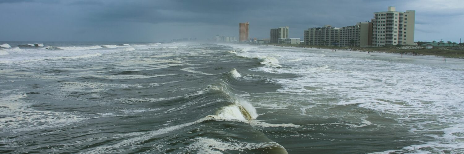
A hurricane is often remembered by its wind speed, but the water can do the most damage. When a strong storm moves toward land, its winds push ocean water toward the coast, piling it higher than the normal tide and forcing it into places that are usually dry. That rising water is called storm surge, and it can turn streets, marshes, bays, and neighborhoods into fast-moving extensions of the sea.
Storm surge is especially dangerous because it does not behave like a simple wave that crashes and disappears. It can spread inland, fill low areas, trap people behind flooded roads, and put pressure on buildings from several directions at once. The National Hurricane Center warns about surge using expected water height above normally dry ground, because a few feet can separate a difficult flood from a life-threatening one.
What Storm Surge Actually Is
Storm surge is an abnormal rise in seawater during a storm, above the level expected from the ordinary astronomical tide. The main force behind it is wind. As hurricane winds rotate around the storm, they drag the ocean surface with them and push water toward the coast. Near land, that water has fewer places to go, so it piles up and moves inland.
Storm surge is not the same as storm tide, though the two are closely related. Storm surge means the extra water produced by the storm. Storm tide means the total water level once the surge is combined with the normal tide. If a hurricane arrives near high tide, the same storm surge can produce a much higher storm tide than it would at low tide.
The shape of the coast matters too. A broad, shallow continental shelf can let water build up more easily than a steep coast where the seafloor drops away quickly. Bays, sounds, river mouths, and inlets can funnel water into narrower spaces, raising levels in places that may be miles from the open beach. This is why two towns the same distance from a hurricane’s center can face very different water hazards.
Why Category Numbers Do Not Tell the Whole Story
The familiar hurricane categories are based on sustained wind speed. They are useful for understanding wind damage, but they do not directly measure storm surge. A Category 2 hurricane can produce a severe surge if it is large, slow-moving, and aimed at a vulnerable stretch of coast. A stronger but smaller storm may create less surge in a different coastal setting.
Storm size is one of the biggest reasons. A large hurricane can push water over a wider area for a longer time, giving the ocean more time to pile up along the shore. Forward speed also matters. A slow storm can keep shoving water toward land while rain adds freshwater flooding on top of the coastal flood. A fast storm may still be dangerous, but the timing and shape of the surge can be different.
Storm track matters because the strongest onshore winds are usually on one side of the storm. In the Northern Hemisphere, the right-front part of a landfalling hurricane often produces especially dangerous coastal water levels because wind, forward motion, and storm circulation can work together. That does not mean the rest of the storm is safe. It means surge risk depends on the storm’s full geometry, not just the number assigned to its winds.
This is why meteorologists often separate wind warnings from storm surge warnings. A community can face life-threatening water even if the wind category does not sound extreme. The better question is not only, “What category is it?” but also, “How high could the water rise where people live, travel, and shelter?”
How Water Moves Inland
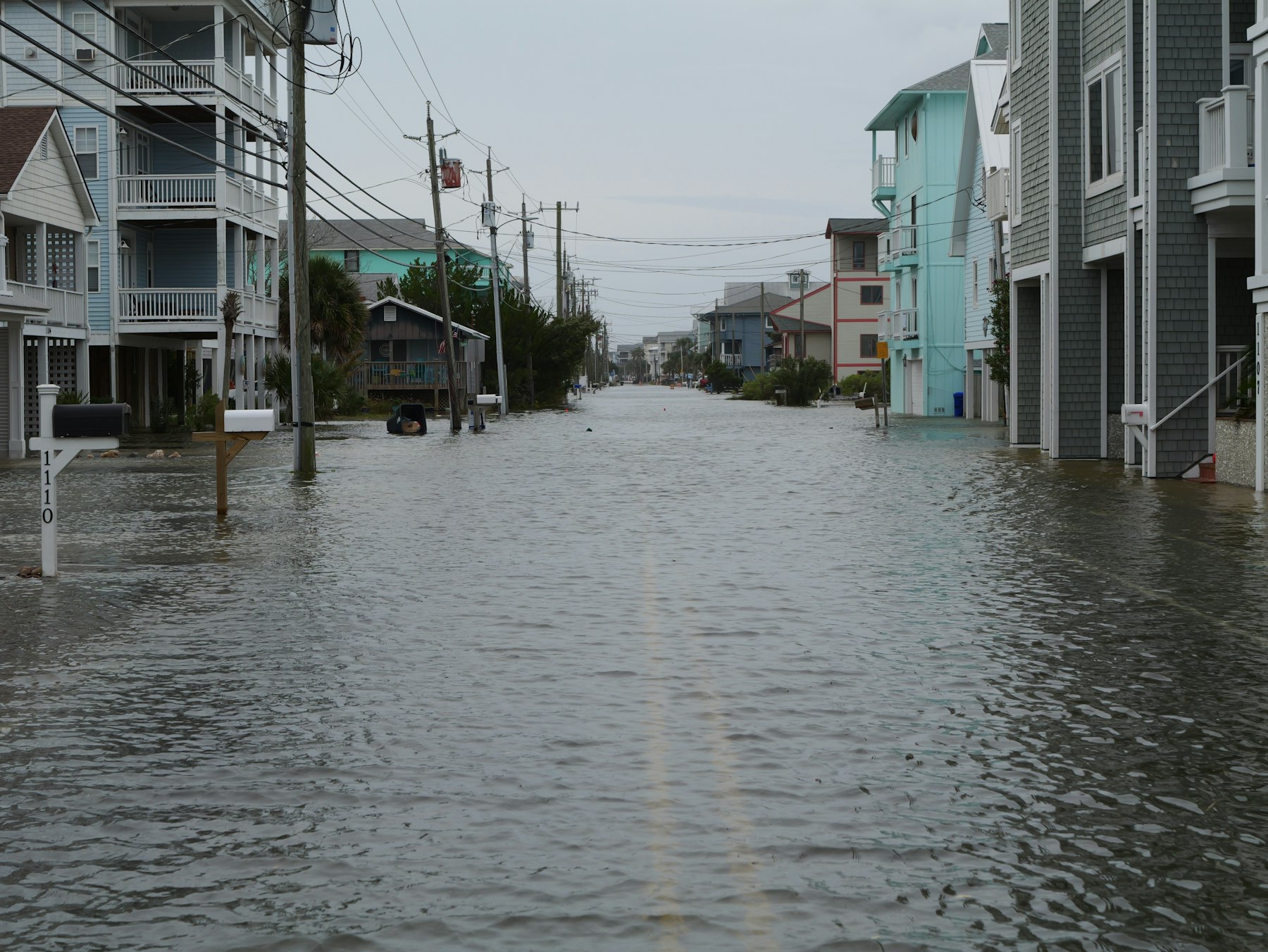
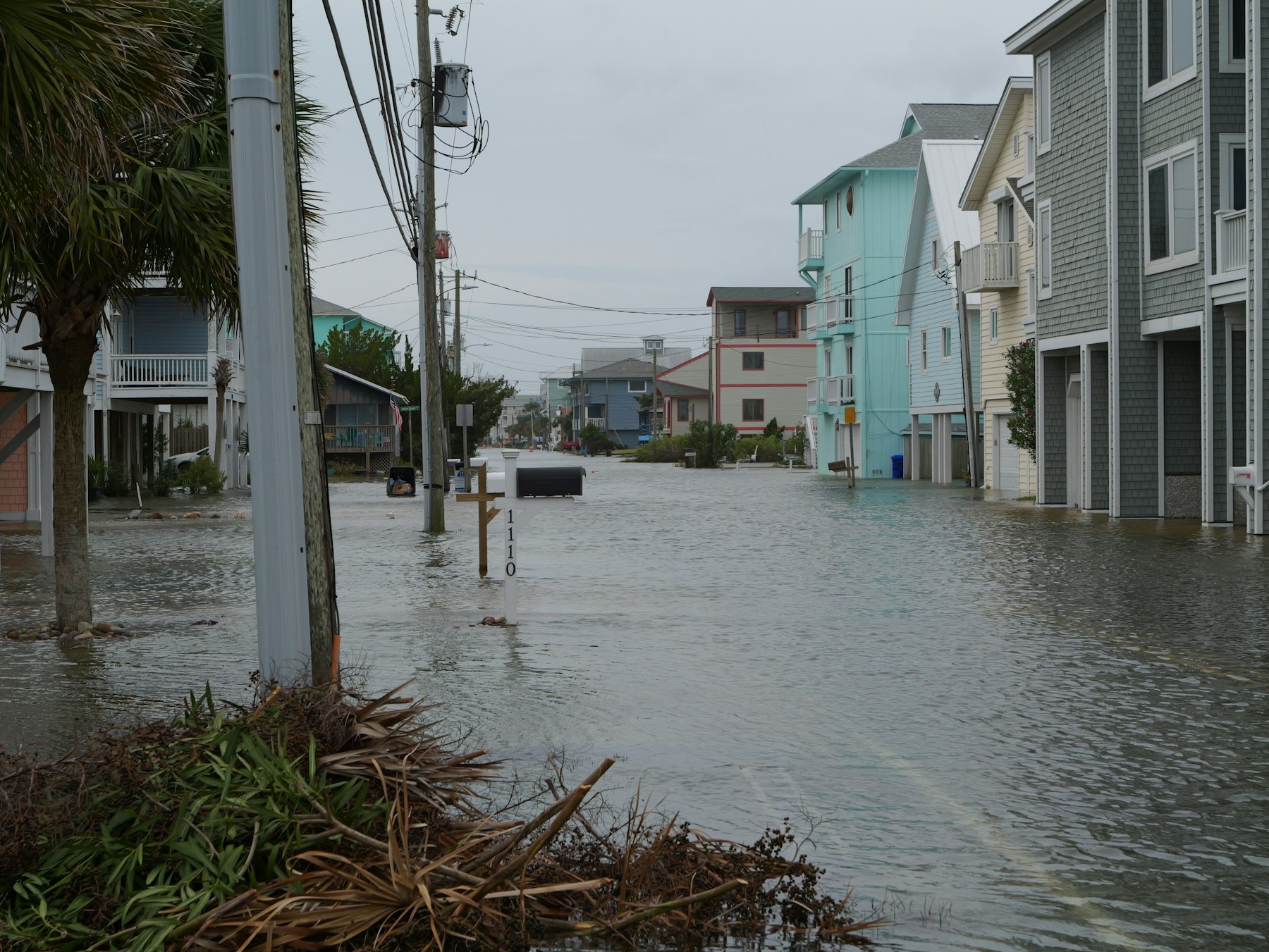
Storm surge begins at the coast, but it does not always stop there. Low-lying roads, canals, tidal rivers, marsh channels, and bays can carry water inland. Once water enters these pathways, it may surround buildings, cut off bridges, and block evacuation routes. In flat coastal areas, a few feet of extra water can spread across a surprisingly large distance.
The water itself is powerful because it has depth, movement, and debris. Floating objects, broken docks, sand, branches, and pieces of buildings can be carried through flooded streets. Even water that looks calm can hide washed-out pavement, open drains, sharp debris, or electrical hazards. Moving water can push vehicles off course and make familiar roads impossible to judge.
Surge can also arrive before the center of the hurricane makes landfall. As winds increase and water rises, roads that looked passable earlier may close quickly. Waiting until the worst wind begins can leave people with fewer choices, especially in barrier islands, low coastal neighborhoods, and communities connected by a small number of routes.
Rainfall flooding can happen at the same time, but it is a different process. Surge comes from the ocean being pushed inland. Rainfall flooding comes from water falling from the sky and running across land into streams, streets, and drainage systems. During a hurricane, both can overlap, which makes the final flood pattern more complicated than either hazard alone.
How Forecasters Estimate Storm Surge
Forecasters use observations, storm models, tide data, elevation maps, and coastal geography to estimate how high water could rise. The National Hurricane Center uses storm surge products to show areas that may face dangerous inundation, measured as height above ground level. That wording matters. A forecast of several feet above ground means water may cover normally dry land by that amount, not simply rise a few feet offshore.
One important tool is the Sea, Lake, and Overland Surges from Hurricanes model, often shortened to SLOSH. It helps estimate how storm winds, pressure, track, size, speed, tides, and coastal shape may combine to produce flooding. Like all models, it is not a crystal-clear picture of one exact future. It is a way to test dangerous possibilities before the water arrives.
Forecast uncertainty is part of the challenge. A small shift in track can move the worst surge into a different bay or coastline. A change in storm size can widen the area at risk. Tide timing can raise or lower the final storm tide. Because of these uncertainties, storm surge warnings are designed around danger, not precision down to a single street corner.
NOAA’s 2026 Atlantic hurricane outlook called for a below-normal season, with the season running from June 1 to November 30. That kind of outlook is useful, but it does not remove local risk. A quiet season can still produce a damaging landfall, and a single storm aimed at the wrong coastline can be enough to create a serious surge emergency.
Why Preparation Depends on Place
Storm surge risk is local. Elevation, distance from water, nearby bays, barrier islands, wetlands, levees, dunes, seawalls, road layout, and drainage all change what a hurricane can do. A home that seems far from the beach may still be vulnerable if it sits near a tidal creek or low road connected to the coast. A neighborhood on slightly higher ground may face less surge but still lose access if surrounding roads flood.
This is why evacuation zones are usually based on water risk, not just distance from shore. Local emergency managers study maps, past storms, transportation routes, and elevation to decide which areas may need to leave first. The safest plan is built before a storm forms: know the zone, know the route, and know where official local warnings come from.
Strong coastal protection can reduce some impacts, but it cannot erase the hazard. Dunes, wetlands, seawalls, flood gates, and raised buildings can all help in different ways, yet each has limits. Wetlands can slow and store some water. Dunes can absorb wave energy. Elevated homes can reduce direct flood damage to living spaces. None of these features makes a dangerous surge harmless.
The most useful mental shift is to treat surge as moving water with weight and reach, not as a line on a beach. The danger is not only at the moment waves hit the shore. It is in the water that spreads through streets, rises under buildings, fills evacuation routes, and lingers after the wind has moved on.
Reading the Warning Before the Water Arrives
A storm surge watch means dangerous rising water is possible in the watch area, generally within the next couple of days. A storm surge warning means there is danger of life-threatening inundation from rising water moving inland from the shoreline, usually within about 36 hours. These warnings are not issued to describe ordinary nuisance flooding. They are meant to focus attention on places where water could threaten lives.
Forecast graphics can be easy to misunderstand if they are treated like exact property-level predictions. Storm surge risk maps are designed for community awareness and emergency planning, not for deciding that one specific building will be dry while the next one floods. The useful lesson is broader: if a map or local order places an area in a surge zone, the safest decision has to be made before roads become unreliable.
Storm surge explains why hurricane readiness cannot stop at boarding windows or watching wind categories. Wind can tear, break, and throw. Water can lift, carry, surround, and isolate. The strongest preparation begins with understanding which hazard is likely to reach a place first and which one could make it impossible to leave.
When a hurricane threatens the coast, the ocean does not simply stay in its normal boundary. Wind, tide, geography, and timing can combine to move water into everyday spaces. That is what makes storm surge so dangerous: it turns a familiar landscape into a changing flood zone, often before people can see the full size of the problem from their own front door.


Add comment