A summer thunderstorm can seem like a single event: dark clouds arrive, rain falls hard, wind rushes through, and then the sky begins to brighten. But the storm may leave behind something that keeps working long after the heaviest rain has moved on. A spreading pool of cool air can slide outward along the ground, shove warm air upward, and become the starting line for another storm nearby.
Meteorologists call that moving edge an outflow boundary. It is also often called a gust front, especially when people at the ground feel the sudden wind shift that comes with it. NOAA’s National Weather Service describes an outflow boundary as the line separating thunderstorm-cooled air from the surrounding air, much like a small cold front created by the storm itself. That line can last for hours, travel many miles from the storm that made it, and sometimes help new thunderstorms form where the air is already warm, humid, and unstable.
A Storm Makes Its Own Mini Cold Front
Inside a thunderstorm, air is constantly moving. Warm, moist air rises in the updraft, cools, condenses, and builds the cloud upward. Rain and hail begin to fall through the storm, dragging air downward with them. Some of that descending air is cooled even more as raindrops evaporate, because evaporation takes heat from the surrounding air.
By the time that downdraft reaches the ground, it is often cooler and denser than the air around it. Dense air does not rise easily. It spreads outward instead, the way spilled water spreads across a floor. The leading edge of that spreading air is the outflow boundary.
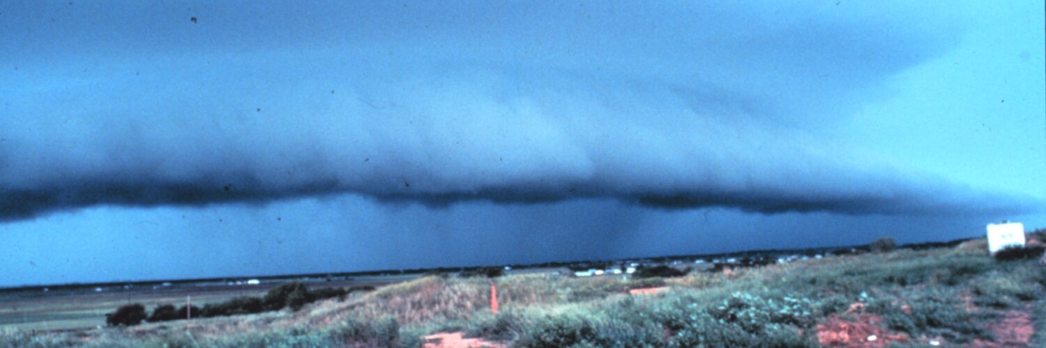
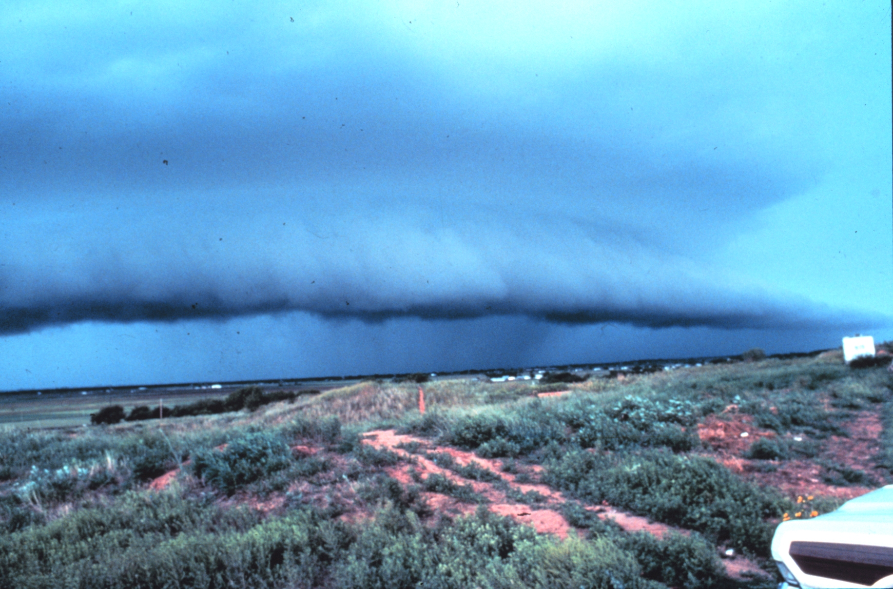
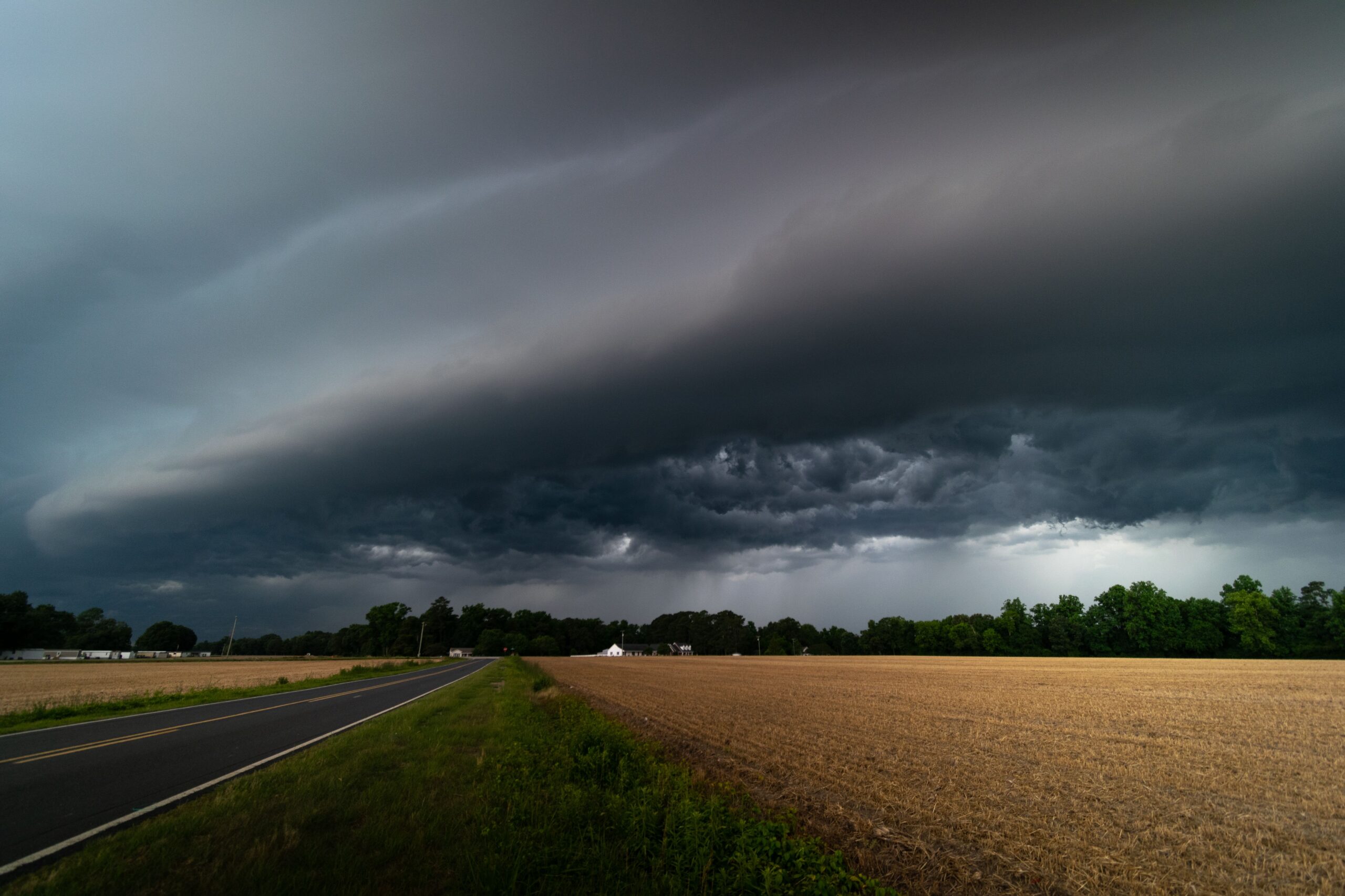
That is why a thunderstorm can send wind ahead of the rain. The gusty air may arrive as a sudden breeze, a blast of dust, a temperature drop, or a dark shelf cloud rolling under the storm. The rain-cooled air is plowing underneath warmer air near the ground, forcing it upward along the boundary.
Why Rising Air Can Start Another Storm
Thunderstorms need a few ingredients: moisture, unstable air, and a trigger that gives warm air its first upward push. Sometimes the trigger is a cold front, a dryline, a sea breeze, a mountain slope, or daytime heating. An outflow boundary can do the same job on a smaller, more local scale.
The lifting happens because the cool outflow air is denser than the warm air in front of it. As the boundary advances, it acts like a wedge. Warm, humid air is pushed up and over the cool pool. If that rising air reaches a level where it can keep rising on its own, a new towering cloud can grow. With enough moisture and instability, that cloud can turn into a fresh thunderstorm.
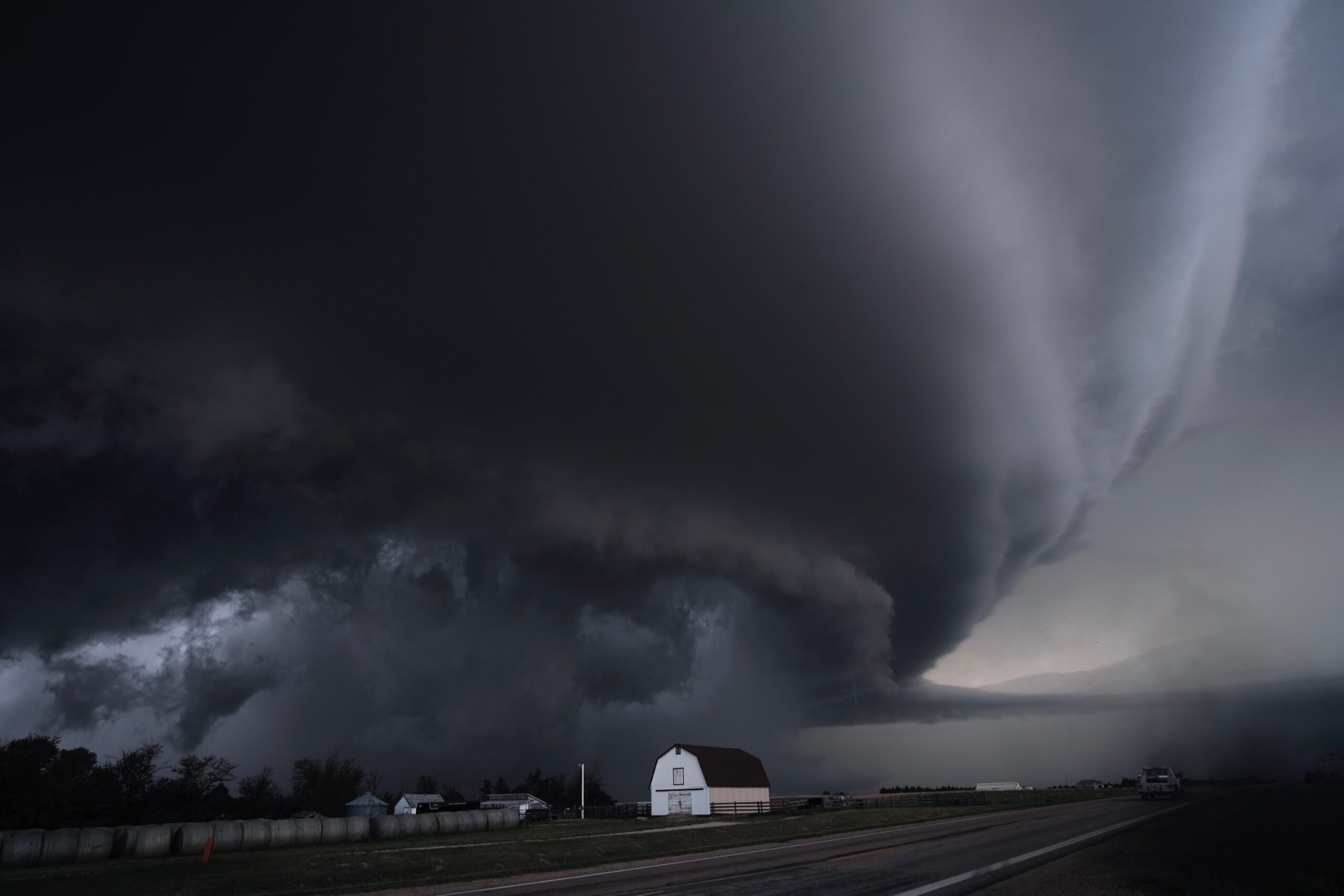
This is one reason storms can appear to multiply on radar during a summer afternoon. One cell drops rain and sends out a boundary. That boundary meets warm air and starts another cell. Two boundaries from separate storms may collide and produce stronger lift than either boundary could create alone. A boundary may also run into a larger weather feature, such as a cold front, and sharpen the lift along that line.
The National Weather Service storm-training material lists outflow boundaries among common trigger mechanisms for thunderstorm development. It also notes that moving storm outflow can lift air around the storm’s edge, helping new storms grow on the periphery. That is the key: the old storm is not simply leaving; it is reshaping the air around it.
What Outflow Boundaries Look Like on Radar and in the Sky
Outflow boundaries are often easiest to notice when they reach people at the ground. A calm, muggy afternoon may suddenly turn breezy. Leaves flip, dust lifts from a field, flags swing around, and the temperature may drop in just a few minutes. If the boundary is strong, the wind can arrive before the rain or even without much rain at all.
In the sky, a shelf cloud can mark the leading edge. Shelf clouds are low, horizontal, wedge-shaped clouds that form as warm air rises over the cool outflow. They can look dramatic because they sit at the boundary between two very different air masses: chilled storm air spreading outward below and warmer air being lifted above.
On radar, an outflow boundary may appear as a thin arc or fine line moving away from a thunderstorm. It does not always look like heavy rain. Sometimes radar detects insects, dust, or tiny droplets gathered along the converging winds. To a forecaster, that faint line can be important because it shows where the atmosphere is being nudged upward.
Why the Same Boundary Can Build or Break Storms
An outflow boundary is not automatically a storm maker. It can help a new storm form only if the air ahead of it is ready to rise. If the air is warm, humid, and unstable, the boundary may provide just enough lift to start deep cloud growth. If the air is dry or stable, the same boundary may pass through with only a wind shift and a few ragged clouds.
Outflow can also weaken the storm that produced it. A thunderstorm needs a steady supply of warm, moist inflow near the ground. If its own cool outflow spreads too quickly and cuts off that supply, the storm may collapse. This is common with short-lived air-mass thunderstorms: the downdraft outruns the updraft, the storm’s fuel line is disrupted, and the cell rains itself out.
Stronger wind shear can change the outcome. When winds change speed or direction with height, the storm’s updraft and downdraft may stay more separated. That allows a thunderstorm to keep drawing in warm air while still sending out cool outflow. In organized storm lines, outflow can repeatedly lift air along the leading edge, helping the line maintain itself for a longer distance.
That balance explains why storm forecasts are so tricky. A boundary that looks harmless at noon may become important by late afternoon if sunshine heats the air ahead of it. Another boundary may race into cooler air and fade. The boundary is only one part of the atmosphere, but it can decide where the next storm begins.
The Wind Hazard Hidden in the Boundary
Outflow boundaries are not only interesting because they can start storms. They can also carry strong straight-line winds. In 2021, Keith Sherburn, Matthew Bunkers, and Angela Mose published a study in Weather and Forecasting comparing radar-detected outflow-boundary speeds with measured peak wind gusts from automated stations. Their dataset included 943 cases across the contiguous United States, showing why these boundaries matter to forecasters trying to warn about damaging thunderstorm winds.
The danger comes from fast-moving air spreading outward near the ground. A gust front can push loose objects, snap small branches, make driving harder, and create sudden low-level wind shear near airports. In dry places, strong outflow can lift dust into a wall-like cloud. In some storm environments, small spinups called gustnadoes can form along the gust front, though they are different from tornadoes produced by a rotating thunderstorm updraft.
For someone watching the weather, the practical signal is simple: a sudden cool wind from a storm is not just refreshing air. It may be the leading edge of a stronger wind surge, and it may arrive before heavy rain or lightning reaches the same spot. If thunder is close enough to hear, the safest place is already indoors.
How to Read the Pattern Without Overreading It
Outflow boundaries help explain why weather can change sharply across short distances. One neighborhood may get a gusty wind shift and clear skies. A few miles away, the same boundary may lift warm air enough to build a new storm. That unevenness is not random; it reflects small boundaries, pockets of moisture, sunshine, terrain, and the timing of earlier storms.
Still, an outflow boundary is not a promise that another storm will form. It is better understood as a moving opportunity for lift. The atmosphere still needs fuel. Warm, humid air near the ground, colder air aloft, and weak enough capping must line up with the boundary’s push. When those pieces do line up, the result can look sudden because the trigger was invisible until clouds began to rise.
That is why meteorologists watch old storms as carefully as new ones. The remains of one thunderstorm can shape the next hour of weather across a wide area. A faint radar line, a shelf cloud, a wind shift, or a sharp temperature drop may all point to the same hidden process: cool storm air spreading outward, lifting the air ahead of it, and writing the next chapter of the afternoon sky.


Add comment