A hurricane category can sound like a complete verdict. Category 1 seems manageable, Category 3 sounds serious, and Category 5 feels almost unimaginable. The number is useful, but it is narrower than many people think. It describes one part of the storm: wind speed.
That distinction matters every hurricane season. The National Hurricane Center uses the Saffir-Simpson Hurricane Wind Scale to estimate possible wind damage, but the same agency is clear that the scale does not measure storm surge, rainfall flooding, tornadoes, storm size, or how long dangerous conditions will last. A lower-category storm can still flood homes, wash out roads, knock out power, and create life-threatening conditions far from the exact landfall point.
What the Category Number Actually Measures
The Saffir-Simpson scale ranks hurricanes from Category 1 to Category 5 using maximum sustained wind speed. In the Atlantic and eastern Pacific, a tropical cyclone becomes a hurricane when its sustained winds reach 74 miles per hour. Category 1 covers 74 to 95 mph. Category 2 covers 96 to 110 mph. Category 3 begins at 111 mph, which is why Categories 3, 4, and 5 are called major hurricanes. Category 4 runs from 130 to 156 mph, and Category 5 begins at 157 mph.
The phrase maximum sustained wind is doing important work. It does not mean the strongest gust anyone might feel. A gust is a short burst. Sustained wind is a steadier measurement over a longer moment, and it gives forecasters a common way to compare storms. The number also describes the strongest winds in the storm, usually near the eyewall, not the wind that every town in a warning area will experience.
That makes the category useful, especially for estimating damage to buildings, trees, power lines, signs, and roofs. A Category 1 hurricane can damage shingles, gutters, branches, and older mobile homes. A Category 3 hurricane can cause devastating wind damage, especially to weaker structures. Category 4 and 5 winds can tear roofs and walls from buildings and leave some areas unlivable for weeks or months.
Why a Wind Scale Cannot Describe Every Hazard
Wind is only one way a hurricane harms people and places. Storm surge can push ocean water onto land, especially along low-lying coasts, bays, and river mouths. Heavy rain can create flash flooding or river flooding even when the center of the storm moves inland and weakens. Tornadoes can form in outer rain bands. Rough surf and rip currents can affect beaches long before or after the worst winds arrive.
This is why a Category 1 or Category 2 hurricane can still be deadly. If the storm moves slowly, it can drop enormous amounts of rain over the same region. If it approaches a vulnerable coastline at the wrong angle, water can pile up against land. If the storm is physically large, tropical-storm-force winds and coastal flooding can affect a wide area even when the highest category number is not extreme.
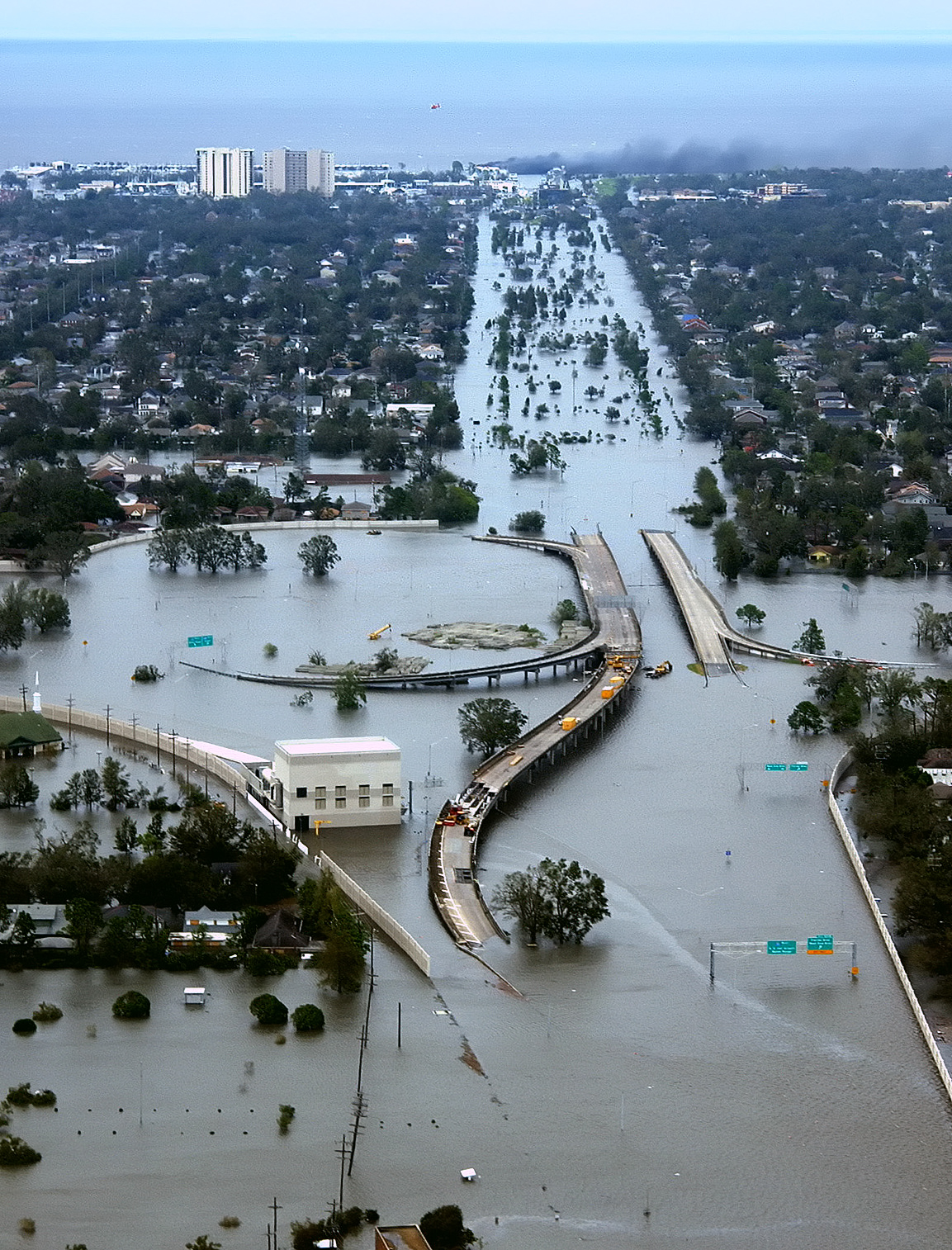
Hurricane Katrina is a familiar example of why the category number alone can mislead. It was a Category 5 storm over the Gulf of Mexico, then made landfall as a Category 3 hurricane in Louisiana in 2005. The final category at landfall did not capture the full disaster. Storm surge, levee failures, flooding, and infrastructure vulnerability shaped much of the damage and loss of life.
Storm Size and Track Can Change the Real Risk
Two hurricanes with the same category can feel very different on the ground. A compact storm may have a tight core of extreme wind near the eye. A larger storm may spread damaging winds, surge, rain, and high waves over a much broader region. The category number does not tell you which one you are facing.
Track matters just as much. A small shift in the path can move the strongest winds or highest surge from one stretch of coast to another. In many storms, the worst surge occurs where wind pushes water toward land for hours. A community outside the center of the forecast track can still face serious danger if it sits in the part of the storm where water, wind, and rainfall line up badly.
The National Hurricane Center’s 2026 cone graphic changes are partly about this communication problem. The main cone has long shown where the center of a storm is likely to travel, based on past forecast errors. Beginning with the 2026 season, the operational cone graphic also includes inland tropical storm and hurricane watches and warnings for U.S. areas when they are in effect. That helps show that wind risk can extend inland, not just along the coastline or inside the center-line track.
Why Categories Can Rise or Fall Before Landfall
Hurricane categories can change quickly because storms are living weather systems. A hurricane may strengthen over very warm water with low wind shear and a well-organized core. It may weaken if dry air enters the circulation, wind shear disrupts the storm, cooler water cuts off fuel, or land begins to break apart the circulation.
That is why a storm’s earlier category does not guarantee its landfall category. A storm that once reached Category 5 can weaken before landfall. A weaker hurricane can also intensify quickly if conditions become favorable. Forecasters pay close attention to the trend, not just the latest label, because communities need time to prepare before the category changes again.
Air pressure, satellite appearance, hurricane hunter observations, radar structure, and ocean heat all help forecasters judge strength. Still, the public-facing category stays intentionally simple. It is a wind-damage shorthand. Simplicity makes it memorable, but it also means readers have to pair it with warnings, rainfall forecasts, surge maps, and local emergency instructions.
How to Read the Category Without Getting Misled
The safest habit is to treat the category as a starting point, not a summary. A Category 4 hurricane deserves urgent attention because the wind damage potential is severe. A Category 1 hurricane also deserves attention if it is forecast to stall, bring heavy rain, push water into bays, or hit a place with fragile roads, trees, power lines, or drainage systems.
When tracking a storm, look for several pieces of information together:
- Category: the wind-damage rating based on maximum sustained winds.
- Watches and warnings: the official alerts that show where dangerous conditions may occur.
- Storm surge forecast: the possible height and location of coastal flooding.
- Rainfall forecast: the flood risk from slow movement or repeated bands of rain.
- Local guidance: evacuation zones, shelter information, road closures, and emergency instructions.
Those details work together. A hurricane’s category may make the headline, but local risk depends on geography. A barrier island, a river valley, an inland mountain community, and a city with poor drainage can all face different hazards from the same storm.
The Number Is Useful, But It Needs Context
Hurricane categories remain valuable because wind can be destructive and because a simple scale helps people compare storm intensity quickly. A jump from Category 1 to Category 3 is not just a small wording change. It signals a much greater potential for structural damage, power outages, and dangerous debris.
The problem begins when the category becomes the only number people watch. A weakening storm can still carry a dangerous surge. A slow storm can turn rain into the main threat. A broad storm can affect communities far from the center. A below-normal seasonal outlook can still include one storm that reaches land at the wrong place and time.
A better question than “What category is it?” is “What hazards are expected where I am?” The category tells part of the story. The warnings, surge forecast, rainfall forecast, track, storm size, and local geography fill in the rest. When those pieces are read together, the hurricane number becomes what it was meant to be: a useful signal, not the whole storm.


Add comment