El Niño can sound like a distant ocean term until it starts showing up in seasonal forecasts, hurricane outlooks, winter weather maps, and news about drought or flooding. The pattern begins in the tropical Pacific Ocean, but its influence can travel through the atmosphere like a long chain reaction. A patch of warmer-than-usual water near the equator changes where thunderstorms form. Those thunderstorms shift wind patterns above them. The altered winds then help steer storm tracks, rainfall, and temperature patterns across parts of the world.
On June 11, 2026, NOAA’s Climate Prediction Center issued an El Niño Advisory, reporting that El Niño conditions had developed and were expected to strengthen into the Northern Hemisphere winter of 2026-27. That does not mean every forecast suddenly becomes certain. It means one of the planet’s strongest seasonal climate signals is active, giving forecasters a better sense of which outcomes are more likely. Understanding the pattern helps explain why a change in Pacific Ocean water can matter to someone watching a winter forecast in the United States, a hurricane outlook in the Atlantic, or rainfall changes across the tropics.
The Pacific Ocean Pattern Behind El Niño
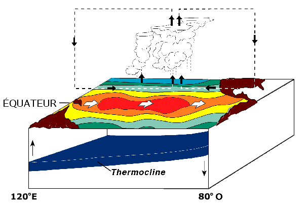
Under ordinary tropical Pacific conditions, trade winds blow from east to west along the equator. These winds push warm surface water toward Indonesia and Australia. Near the west coast of South America, colder water rises from below to replace the surface water that has been pushed away. That process, called upwelling, brings cooler, nutrient-rich water toward the surface and helps keep the eastern equatorial Pacific cooler than the western side.
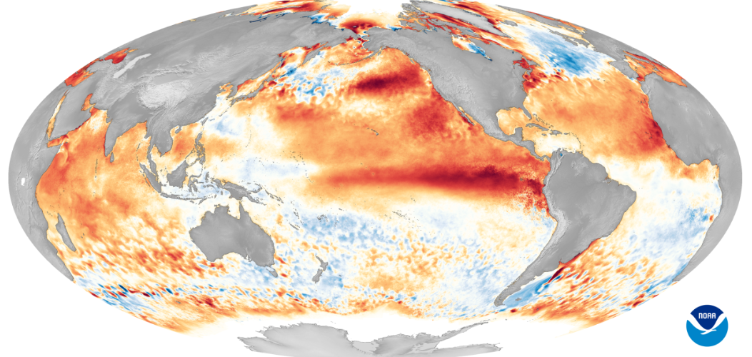
El Niño begins when this usual pattern weakens. The trade winds slow down, and warm water spreads eastward across the central and eastern equatorial Pacific. NOAA tracks this change partly through sea surface temperature measurements in regions such as Niño-3.4, a monitoring zone in the central Pacific. In the June 2026 advisory, the latest weekly Niño-3.4 value was reported at +0.7 degrees Celsius, high enough to show a meaningful warm shift when combined with atmospheric evidence.
The ocean change alone is not the whole story. El Niño is part of the El Niño-Southern Oscillation, or ENSO, which couples ocean temperatures with atmospheric pressure, winds, and rainfall. When the ocean warms in the right region and the atmosphere responds, the pattern becomes more powerful than a simple patch of warm water. It becomes a climate engine that can tilt seasonal odds across large regions.
Why Warm Water Changes the Air Above It
Warm ocean water adds heat and moisture to the air above it. In the tropics, that extra warmth can help air rise, form clouds, and produce thunderstorms. During neutral conditions, the most active tropical rainfall often sits farther west over the warm pool near Indonesia and the western Pacific. During El Niño, the strongest thunderstorm activity can shift eastward toward the central and eastern Pacific.
That eastward shift matters because tropical thunderstorms are not just local rainmakers. They act like large atmospheric pumps, moving heat upward and disturbing wind patterns around them. When the main area of tropical rising air moves, the surrounding circulation has to adjust. High-altitude winds, pressure belts, and jet-stream patterns can all respond.
The result is not a neat one-to-one forecast. El Niño does not guarantee that a particular city will be wet, dry, warm, or cold on a particular day. Instead, it changes the background odds. A region that might normally have many possible winter outcomes may lean more strongly toward one pattern. Forecasters still need shorter-range weather models, local data, ocean temperatures, snow cover, soil moisture, and many other clues. El Niño is a major clue, not the whole forecast.
The Difference Between El Niño, La Niña, and Neutral Conditions
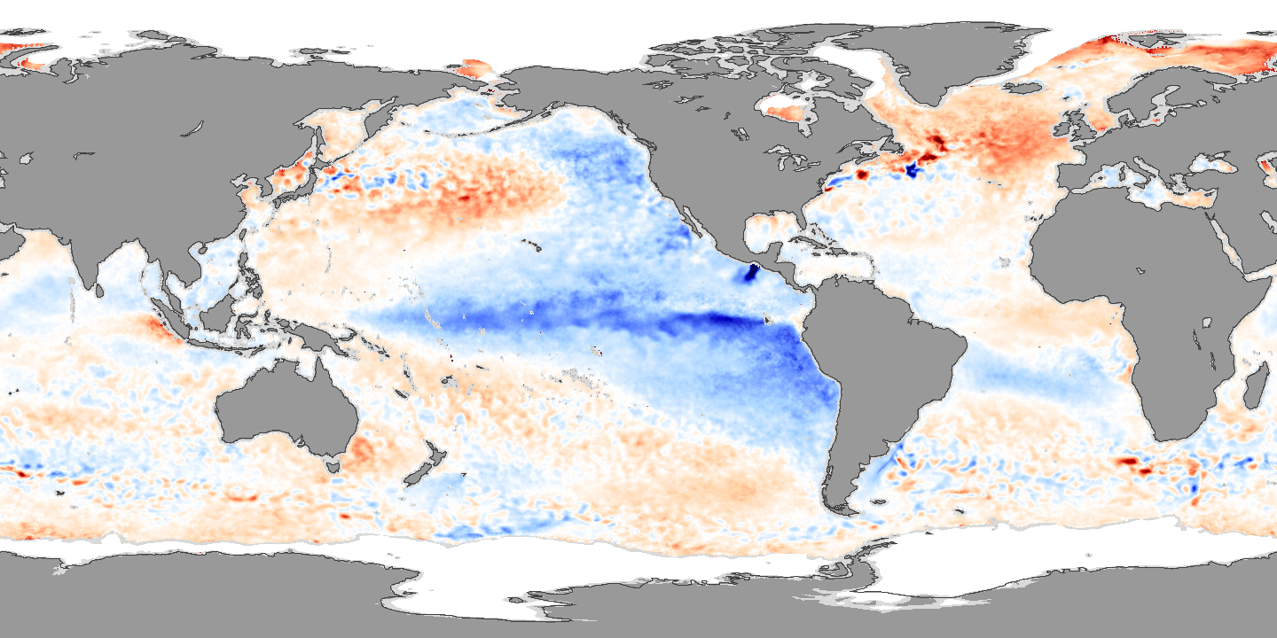
ENSO has three broad phases: El Niño, La Niña, and neutral. El Niño is the warm phase, when the central and eastern tropical Pacific become warmer than average and the usual trade-wind pattern weakens. La Niña is the cool phase, when trade winds tend to strengthen, warm water piles up farther west, and cooler-than-average water becomes more prominent in the central and eastern equatorial Pacific. Neutral conditions sit between those two phases, when neither pattern dominates strongly enough to be declared active.
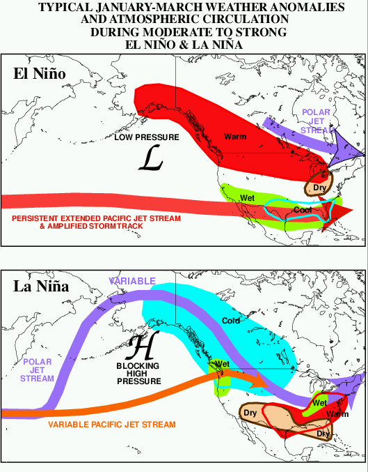
La Niña is not simply El Niño with the colors reversed on a map, though that is a useful first picture. Stronger trade winds during La Niña increase upwelling in the eastern Pacific and often shift tropical rainfall farther west. That different placement of heat and storms changes atmospheric circulation in a different way. In North America, La Niña winters often lean wetter in the Pacific Northwest and drier across parts of the southern United States, while El Niño winters often shift the Pacific jet stream farther south and east.
Neutral years can still bring extremes. A neutral ENSO pattern does not mean normal weather everywhere. It simply means forecasters do not have a strong El Niño or La Niña signal to lean on. Other climate patterns, ocean temperatures, blocking highs, Arctic air outbreaks, and local storm tracks can become more important in shaping the season.
How El Niño Reaches Distant Weather Patterns
The long-distance influence of El Niño is called a teleconnection. The idea is simpler than the word sounds: one part of the climate system can affect another part far away because the atmosphere is connected. A major shift in tropical Pacific rainfall can send waves through the upper atmosphere. Those waves can help reposition the jet stream, the fast-moving river of air that guides many mid-latitude storms.
In the United States, a mature El Niño often has its clearest seasonal influence during winter. NOAA’s National Ocean Service explains that the Pacific jet stream tends to move south and spread farther east during El Niño. That pattern often favors wetter conditions across parts of the southern United States and milder, drier conditions in parts of the northern United States and Canada. The word often is doing important work. Local outcomes vary because El Niño interacts with other climate patterns, land conditions, and the chaotic details of weather.
El Niño also affects marine ecosystems. When upwelling weakens along parts of the Pacific coast, fewer nutrients reach the sunlit surface layer where phytoplankton grow. That can ripple through food webs, affecting fish, seabirds, and marine mammals. The same ocean-atmosphere pattern that appears on a climate map can therefore show up in fisheries, coastal economies, and wildlife stress.
Why Hurricane Outlooks Pay Attention to ENSO
ENSO is especially important during Atlantic hurricane season because it can change vertical wind shear over the tropical Atlantic. Vertical wind shear means winds are moving at different speeds or directions at different heights in the atmosphere. Tropical storms need a fairly organized column of rising warm, moist air. Strong wind shear can tilt that column, disrupt thunderstorms, and make it harder for a storm to strengthen.
NOAA’s Atlantic Oceanographic and Meteorological Laboratory explains that El Niño generally reduces Atlantic hurricane activity by increasing vertical wind shear across the region. The same pattern can make conditions more favorable for tropical cyclones in parts of the eastern and central Pacific, where warmer water and atmospheric changes can support storm formation. La Niña often does the opposite in the Atlantic by reducing wind shear and allowing more storms to organize, though ocean warmth, dry air, Saharan dust, and steering patterns still matter.
This is why a seasonal hurricane outlook can mention a Pacific Ocean pattern even when the storms of concern form thousands of miles away. The Atlantic does not operate in isolation. The tropical atmosphere connects ocean basins, and ENSO is one of the clearest examples of that connection.
How to Read an El Niño Forecast Carefully
An El Niño forecast is a probability statement, not a promise. When NOAA says El Niño conditions are present or likely to strengthen, it is describing a measured climate pattern and the odds of its future development. When seasonal outlooks connect El Niño to rainfall, temperature, or hurricane activity, they are describing increased or decreased chances, not a daily weather script.
Several habits make ENSO forecasts easier to read. First, notice the season. El Niño’s strongest U.S. impacts often appear in winter, while hurricane-season effects become more important during late summer and fall. Second, notice the region. A global pattern can produce opposite effects in different places. Third, separate average seasonal risk from local weather. A wetter-than-usual seasonal tilt can still include dry weeks, and a quieter Atlantic hurricane season can still include a dangerous landfalling storm.
It also helps to watch the evidence forecasters use. Sea surface temperature anomalies show whether the central and eastern tropical Pacific are warmer or cooler than average. Trade-wind anomalies show whether the atmosphere is reinforcing the ocean pattern. Subsurface ocean heat matters because warm water below the surface can help an El Niño grow. Pressure patterns, including the Southern Oscillation, reveal whether the atmosphere is coupled to the ocean.
El Niño is powerful because it links water, wind, clouds, and probability. It begins with changes along the equator, but its importance comes from the way those changes organize the atmosphere. A forecast that mentions El Niño is really pointing to a larger lesson: weather is local when it arrives, but the forces shaping it can begin across an ocean.


Add comment