A flash flood warning is one of the clearest signs that weather has moved from something to watch into something that may require action right away. It does not mean a road might be damp later in the day. It means flash flooding is imminent or already happening in the warned area, often with only minutes to spare. The National Weather Service uses these warnings when rapidly rising water could threaten people, vehicles, homes, streams, low-water crossings, or city streets.
The hard part is that flash flooding can look ordinary until it is not. Rain may be falling a few miles away. A creek may still seem low. A familiar road may look passable because the water has not reached the curb yet. Flash floods are dangerous because the useful warning time can be short, and because water follows land shape, pavement, drains, ditches, canyons, and streambeds faster than most people expect.
Why a Warning Is Different From a Watch
A flood watch or flash flood watch means conditions are favorable for flooding. Heavy rain, saturated soil, snowmelt, tropical moisture, or repeated storms may create trouble, but the exact timing and location are still uncertain. A watch is a planning signal. It is the time to charge a phone, check alerts, think through roads that commonly flood, and avoid being caught far from a safe place.
A flash flood warning is more urgent. According to the National Weather Service, it is issued when a flash flood is imminent or occurring. The warning may be based on radar estimates of intense rainfall, stream gauge data, reports from emergency managers, trained spotters, or direct evidence that water is already covering roads and low areas. When the alert arrives, the safest assumption is that the dangerous part may already be close.
Flash flood warnings can also come with impact language. The National Weather Service moved flash flood warnings into an impact-based format so alerts can describe the hazard, the source of information, and the expected impact more clearly. Some warnings carry damage threat tags such as considerable or catastrophic. A flash flood emergency is reserved for the most serious situations, when life-threatening flooding is happening or about to happen and urgent action is needed.
How Water Can Rise So Fast
Flash floods are not just regular floods on a smaller scale. A river flood may build over many hours or days as water collects across a large watershed. A flash flood can develop in minutes to a few hours after intense rain, especially when more water falls than the land can absorb or drainage systems can carry away. Steep slopes, narrow valleys, dry washes, burn scars, concrete streets, and already-wet soil can all speed up the process.
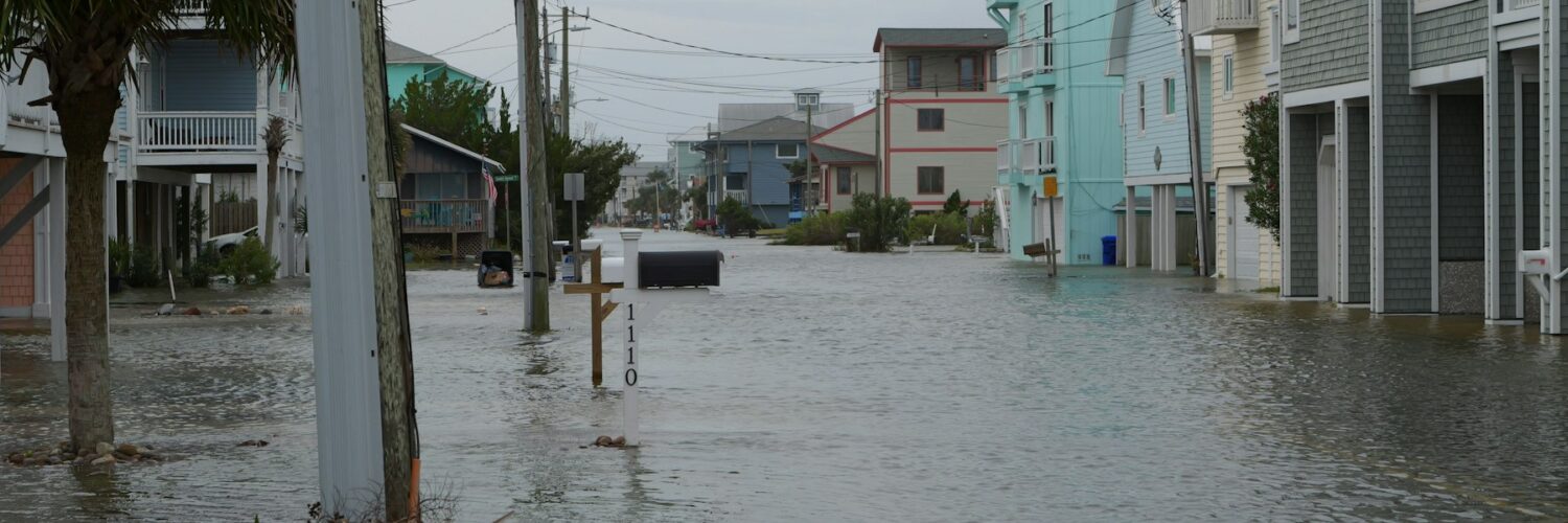
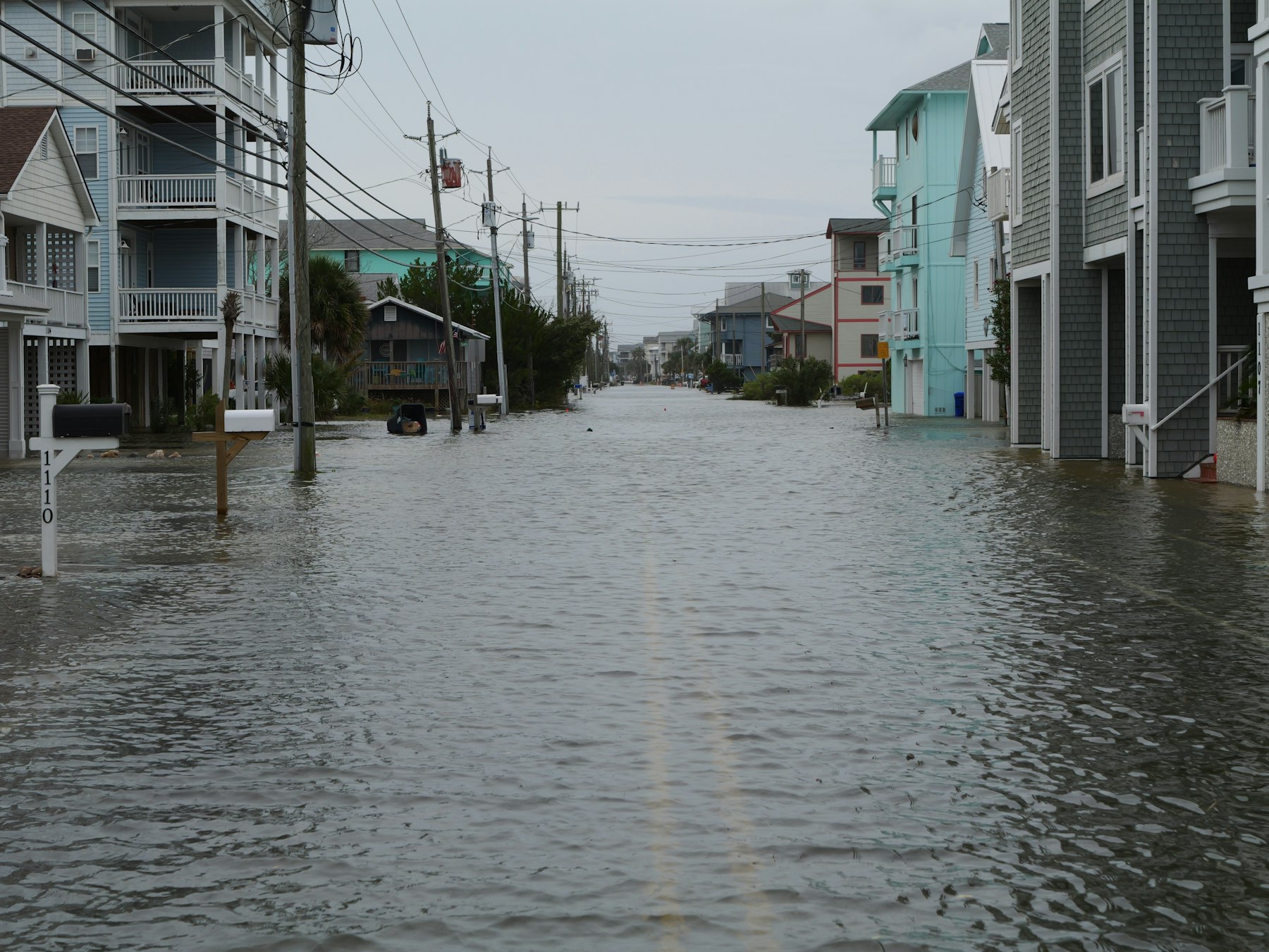
In a city, pavement changes the story. Rain that would have soaked into open ground instead runs across roofs, parking lots, sidewalks, and roads. Storm drains help, but they have limits. If rain falls too hard, leaves and debris clog drains, or water arrives from several streets at once, the system can back up quickly. A dip under a railroad bridge or highway overpass can fill before drivers realize the depth has changed.
In rural and mountain areas, distance can be misleading. A storm upstream may send water into a normally quiet creek even where the sky overhead looks lighter. Slot canyons, desert washes, and small streams can become dangerous because the water is forced through narrow channels. After a wildfire, burned soil may repel water and shed rain faster, raising flash flood risk even in storms that would not have caused the same problem before the fire.
The Road Is Often the Most Dangerous Place
Many flash flood injuries and deaths happen when people try to cross water in vehicles or on foot. The water does not need to look dramatic to be dangerous. The National Weather Service warns that six inches of fast-moving floodwater can knock over an adult, twelve inches can carry away many cars, and two feet can carry away sport utility vehicles and trucks. Those numbers are sobering because many flooded roads do not show their true depth from a driver’s seat.
There is another hidden risk: the road may not be there anymore. Fast water can wash out pavement, undermine shoulders, move debris, or hide a collapsed culvert. A car entering water can lose traction, float, stall, or be pushed sideways. Once a vehicle is trapped, rescue becomes much harder, especially at night or when emergency crews are already responding to multiple flooded locations.
That is why the familiar safety message, Turn Around, Don’t Drown, is more than a slogan. It is a simple rule for a moment when judgment can be tricked by habit. If a road is covered, blocked, or marked by barricades, the safest choice is to find another route or wait. Driving around a barricade is especially risky because it means someone has already identified the crossing as unsafe.
What to Do When the Alert Arrives
The right response depends on where you are, but the first step is to take the warning seriously. Check the warning area, listen for local instructions, and move away from places that collect water. Low roads, creek crossings, underpasses, drainage channels, basements, and campsites near streams deserve immediate attention. If local officials tell people to evacuate or move to higher ground, follow that instruction without waiting for visible flooding.
If you are indoors, avoid basements and lower levels when water is rising. Move important items only if it is safe and quick; possessions are not worth being trapped downstairs. Keep a phone charged, but do not depend on a single alert source. Weather radio, local emergency alerts, trusted weather apps, local officials, and nearby observations can all help build the picture.
If you are outside, move to higher ground and away from channels, culverts, and storm drains. Do not walk through moving water to test its depth. Mud, broken pavement, sharp debris, open manholes, and electrical hazards can be hidden below the surface. In parks, canyons, or campgrounds, the safest route may be upward and away from the drainage, not along the streambed.
- Watch: conditions are favorable, so prepare and stay alert.
- Warning: flooding is imminent or occurring, so act now.
- Emergency: a rare, life-threatening flood situation is unfolding, so follow urgent local instructions immediately.
Why Forecasts Cannot Name Every Flooded Street
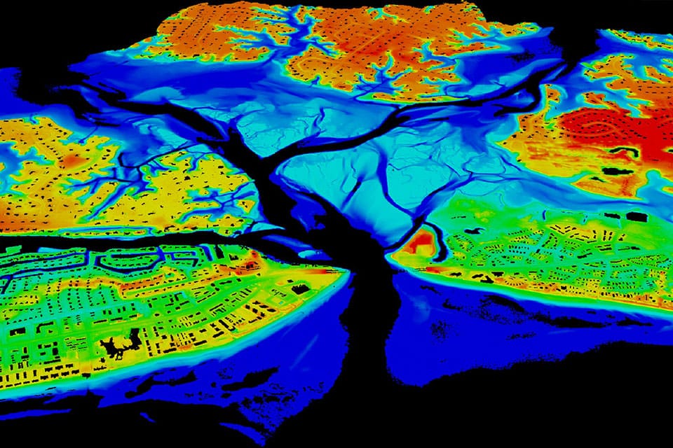
Flash flood forecasting has improved, but it remains difficult because small differences matter. A thunderstorm that stalls over one neighborhood can produce a very different result from a storm that moves a few miles farther east. Rainfall rate, storm duration, soil moisture, terrain, drainage design, vegetation, recent fires, and local stream shape all affect where the water goes. Radar can estimate rainfall, but water on the ground still responds to details that may not fit neatly on a regional map.
That is why warnings often cover a county, part of a county, a watershed, or a polygon-shaped area rather than one street. The warning is not meant to predict that every location inside the boundary will flood equally. It means the ingredients and observations are serious enough that people in the warned area should protect themselves before the situation becomes obvious.
Good local judgment fills in the last mile. If you know a nearby underpass floods during heavy rain, do not wait for a separate alert naming that exact road. If a creek is rising quickly, treat it as evidence. If water is flowing across pavement, assume the depth and current are worse than they appear. Flash flood warnings work best when people combine the alert with what they know about the places they actually travel.

Learning the Landscape Before the Storm
The best time to understand flash flood risk is before a warning arrives. Every community has places where water naturally gathers: low intersections, dry washes, creek crossings, steep streets, construction zones, storm drains, and parking lots at the bottom of slopes. Students can learn a surprising amount by noticing how water moves after an ordinary rain. Where does it pool? Which streets drain slowly? Which sidewalks become little streams?
Maps can help, too. Elevation maps show low ground and drainage paths. Local flood maps show areas with known flood risk, though flash flooding can also happen outside mapped flood zones. Weather forecasts add timing, but land shape explains why two places with the same rainfall can have different outcomes. A warning becomes easier to understand when it is connected to real streets, streams, and routes.
A flash flood warning is not a prediction to debate from a window. It is a signal that the margin for waiting has narrowed. Water can rise faster than a person can reconsider, especially in darkness, traffic, or unfamiliar terrain. The safest response is simple and early: get out of low places, avoid flooded roads, listen for updates, and give moving water more respect than it seems to ask for at first glance.


Add comment