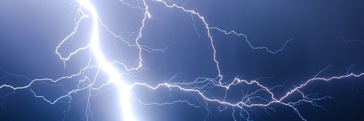
A lightning map can make a thunderstorm feel strangely precise. A storm that looked like a gray blob on the horizon suddenly becomes a cluster of dots, pulses, and bright streaks across a screen. Those marks are not guesses drawn from thunder or rain. They come from instruments that notice the physical signs lightning leaves behind: radio waves, bursts of light, timing differences, and patterns that move through a storm as it grows.
That matters because lightning is both common and dangerous. It can strike before heavy rain arrives, far from the loudest part of a storm, and in places where people still feel safe because the sky overhead has not fully darkened. Detection maps cannot tell anyone exactly where the next strike will happen, but they can show where electrical activity is already occurring and whether a storm is becoming more active. Used wisely, that makes them a powerful tool for weather awareness.
A Lightning Flash Leaves More Than Light
Lightning is an electrical discharge, but it is not a single simple spark. A flash can involve branching channels inside a cloud, a channel reaching toward the ground, or several return strokes that follow the same path so quickly that the bolt appears to flicker. Some flashes remain entirely inside the storm. Others connect cloud and ground. Both kinds can reveal useful information, but different instruments notice different parts of the event.
The visible flash is only one clue. Fast electric currents in lightning channels also produce radio signals, often called sferics. These signals travel outward from the storm and can be detected by sensors at different locations. If several sensors hear the same lightning signal, their timing differences can be used to estimate where the discharge occurred. The method is similar in spirit to figuring out where a sound came from by comparing when it reached different microphones, except the signals are electromagnetic and the timing has to be extremely precise.
NOAA’s National Severe Storms Laboratory describes two major kinds of U.S. lightning detection systems: ground networks that detect radio waves from lightning and satellite instruments that watch for brief optical flashes from above. Neither view is perfect on its own. Together, they help forecasters, researchers, pilots, emergency managers, and ordinary weather watchers understand storms in a way radar alone cannot.
Ground Networks Listen for Radio Bursts
Ground-based lightning detection networks work because lightning is noisy in the radio part of the electromagnetic spectrum. When a stroke moves through a lightning channel, sensors spread across a region can detect the burst. A single sensor may know that something happened, but it cannot locate the strike with enough confidence by itself. A network compares signals from multiple stations, often at least three, to narrow the position.
The National Lightning Detection Network is one well-known ground-based system in the United States. It is especially strong at detecting cloud-to-ground return strokes because those strokes often involve larger currents and stronger radio signals. The Earth Networks Total Lightning Network is another system that detects lightning activity. The word total matters because intracloud lightning can be important too. In many storms, lightning inside the cloud increases before the most dangerous weather reaches the ground.
The timing math is the quiet hero of the process. If a lightning signal reaches one sensor slightly before another, the network can use that difference to estimate where the event occurred. With enough sensors and accurate clocks, the estimated location becomes far more useful. Location accuracy tends to be best when the lightning occurs inside the area covered by the network. Flashes near the edge of a network, or beyond it, can have larger errors or may be missed.
This is why lightning maps sometimes look crisp and sometimes look incomplete. A dot on a public map is not the lightning bolt itself. It is a processed observation, built from a physical signal and a set of assumptions about where that signal most likely came from. That does not make the map unreliable. It simply means the map should be read as weather information, not as a promise that every flash has been captured with perfect detail.
Satellites Watch the Flash From Above
Ground networks are only part of the picture. NOAA’s GOES-R Series satellites carry the Geostationary Lightning Mapper, usually shortened to GLM. Instead of listening for radio waves from the ground, GLM watches for quick changes in light from high above Earth. From geostationary orbit, it continuously observes lightning over the Americas and nearby ocean regions.
That overhead view solves a problem that ground networks cannot fully solve: storms do not stop at coastlines or radar coverage boundaries. Over oceans, mountains, and remote areas, a satellite lightning mapper can still detect activity across a broad region. GLM measures total lightning, including in-cloud, cloud-to-cloud, and cloud-to-ground activity. It can show where flashes are frequent, how activity spreads, and when a storm’s electrical behavior changes.
But GLM also has limits. It detects optical flashes from above, so it does not directly tell whether a lightning channel reached the ground. A ground network may be better for locating cloud-to-ground strokes, while GLM may be better for watching the overall electrical behavior of a storm across a wide area. The most useful interpretation often comes from comparing lightning data with radar, satellite cloud imagery, surface observations, and official forecasts.
Why Lightning Data Matters to Forecasts
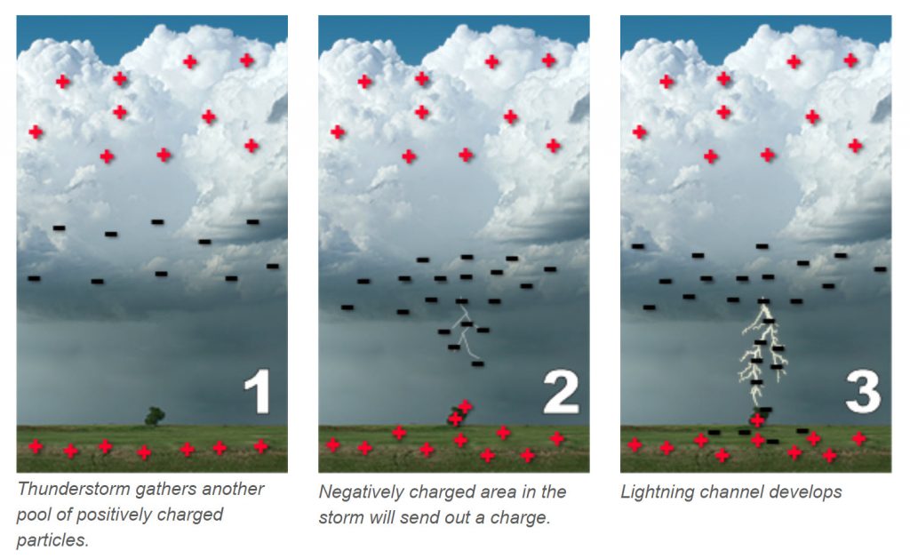
Lightning is more than a hazard marker. It can also be a clue about what is happening inside a storm. Strong updrafts lift water droplets and ice particles into regions where collisions help separate electrical charge. When a storm’s updraft strengthens, lightning activity can increase. A sudden jump in total lightning does not automatically mean a tornado or damaging wind is about to happen, but it can alert forecasters that the storm is changing quickly.
This is especially useful when paired with radar. Radar shows precipitation, motion, and structure. Lightning data shows electrical activity. A storm can look modest on radar while its lightning activity begins to rise, or it can produce dangerous lightning even before rain reaches a specific location. That is one reason weather safety advice treats thunder as a warning sign: if thunder is audible, lightning is close enough to be a concern.
Lightning observations also help beyond severe thunderstorm warnings. Aviation forecasters care about lightning because it marks active convection and turbulence risk. Wildfire managers watch lightning because strikes can ignite fires, especially when storms produce little rain. Outdoor event planners and athletic directors use detection data to decide when fields, pools, parks, and open venues should be cleared.
What Lightning Maps Can and Cannot Tell You
The most common mistake is reading a lightning map as if it predicts the next strike. Detection systems show lightning that has already happened or has just been observed. Some public displays update very quickly, but they are still based on detected events. A clear area on a map does not mean a nearby storm is safe. A storm can produce a new strike outside the cluster of recent dots, and lightning can reach several miles from the rain core.
Another mistake is treating every mark as the same kind of lightning. Some displays distinguish cloud-to-ground strokes from total lightning, but others simplify the data for public viewing. A dense cluster may mean repeated cloud-to-ground strokes, frequent intracloud flashing, or a combination of both, depending on the source. Scale matters too. A satellite product with storm-scale resolution will not behave like a ground network that estimates individual stroke locations.
Good map reading starts with a few practical questions. Is the lightning moving toward your location? Is the cluster growing or weakening? Is thunder already audible? Are official alerts in effect? The map is most useful when it changes behavior, not when a reader stares at a single dot. Storms are moving systems, and lightning data is one layer in a larger weather picture.
The Smart Way to Use a Lightning Map
A useful lightning map turns invisible timing and sensor work into something ordinary people can act on. It does not remove uncertainty, and it should not replace local warnings or common sense. Its strength is that it makes storm electricity visible enough to respect. If lightning is showing up nearby, the safe choice is to move indoors or into a hard-topped vehicle rather than waiting for rain to prove the danger is close.
For learning, lightning detection is also a neat example of science in everyday life. A flash lasts a fraction of a second, yet instruments can turn that burst into a mapped location, a storm trend, and a warning clue. The dots on the screen are not magic. They are physics, sensors, clocks, satellites, and careful interpretation working together fast enough to follow a storm while it is still unfolding.


Add comment