 Akshay Dinesh
A hurricane does not choose its path the way a car chooses a road. Once a tropical cyclone forms, its center is carried by the larger pattern of winds around it. That pattern can be messy, with troughs, ridges, fronts, and nearby storms all tugging in different ways. In the Atlantic, one of the most important steering features is a broad summer high-pressure system often called the Bermuda High.
The Bermuda High matters because it can change where a storm has room to turn. When it sits farther east or leaves a weakness to the north, an Atlantic hurricane may curve away from land over open water. When it expands farther west, it can help push storms toward the Caribbean, the Bahamas, the Gulf of Mexico, or the southeastern United States. The same storm, with the same warm ocean beneath it, can become a very different hazard if the steering pattern around it shifts by a few hundred miles.
What the Bermuda High Is
The Bermuda High is part of the subtropical ridge, a belt of high pressure that often stretches across the Atlantic during the warm season. It is not a solid wall, and it does not stay fixed over one exact point. It grows, shrinks, strengthens, weakens, and shifts as the atmosphere rearranges itself. The name comes from its frequent position near Bermuda and the western Atlantic, but forecasters often think about the whole ridge rather than one neat circle on a map.
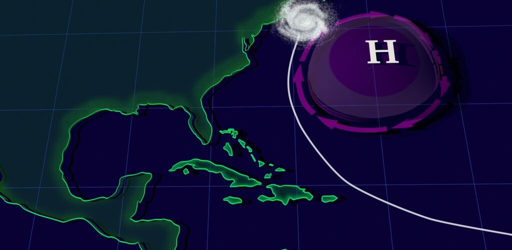
High pressure usually means air is sinking. Sinking air tends to suppress widespread cloud growth, which is one reason high-pressure systems are often linked with fair weather. Around a Northern Hemisphere high-pressure system, winds circulate clockwise. That clockwise flow is the part that matters most for hurricane tracks: along the southern side of the ridge, easterly winds can help carry tropical storms westward; along the western and northern edges, the flow can bend storms northward and then northeastward.
NOAA’s Atlantic Oceanographic and Meteorological Laboratory describes tropical cyclone motion as being controlled, in a broad first approximation, by the surrounding flow through much of the troposphere, the lower and middle part of the atmosphere where weather happens. That is why meteorologists often talk about a storm being “steered.” The storm is powerful, but it is still embedded in a much larger moving atmosphere.
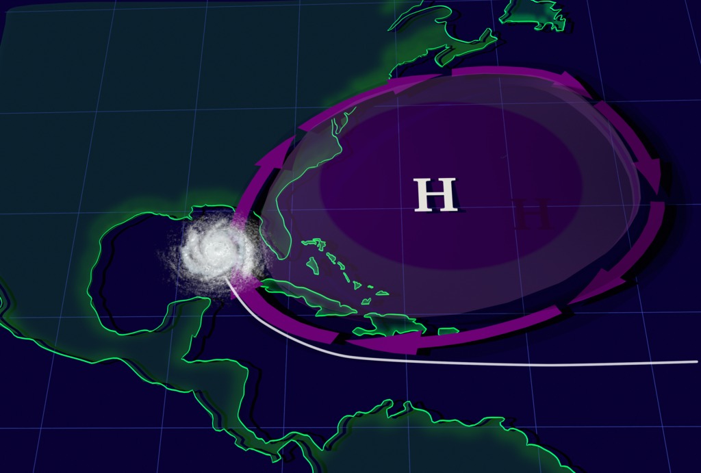
Why Hurricanes Move Around High Pressure
A simple way to picture the Bermuda High is to imagine a large slow-moving roundabout in the atmosphere. Air flows clockwise around the high, and tropical cyclones tend to travel along the outer flow rather than straight through the middle. This does not mean the high has a hard edge. It means the winds around it create preferred pathways, especially for storms moving across the tropical Atlantic.
Many Cape Verde-type hurricanes begin as disturbances that leave Africa and move west across the Atlantic. If a strong ridge lies to their north, the steering flow can keep them moving west or west-northwest for several days. That path can bring storms closer to the Lesser Antilles, Puerto Rico, Hispaniola, Cuba, the Bahamas, Florida, or the Gulf of Mexico, depending on the rest of the pattern.
If the ridge is weaker, smaller, or interrupted by a trough dipping south from the jet stream, the storm may find a weakness and turn poleward earlier. Once it reaches the northern side of the ridge, westerly winds can help pull it back toward the east. This is why some Atlantic hurricanes make dramatic curves out over the ocean while others keep pressing west. The curve is not random; it reflects the position and strength of the steering currents around the storm.
NASA’s Scientific Visualization Studio uses the summers of 2004 and 2005 as a clear example. In a more typical setup, the Bermuda High could help storms move up the East Coast and then out to sea. When the high expanded south and west during those seasons, it helped steer storms toward the Gulf of Mexico instead. That difference is one reason forecasters watch the ridge so closely during hurricane season.
Why Small Shifts Can Change the Risk
The difference between a storm that misses land and a storm that reaches a coastline can come down to steering details that are hard to pin down many days ahead. A hurricane forecast depends not only on where the storm is now, but on where the ridge, troughs, and surrounding winds will be later. If a trough arrives earlier than expected, it may open a path northward. If the ridge holds stronger or stretches farther west, the storm may stay on a lower-latitude track longer.
This is also why the forecast cone widens with time. The cone is not showing the size of the storm, and it is not showing every place that will feel wind, rain, surf, or storm surge. It shows historical uncertainty in the track of the storm’s center. A small track difference far out in the Atlantic can become a much larger difference near land several days later, especially when the forecast depends on whether a storm will catch a weakness in the ridge.
The Bermuda High can also influence the kind of humidity and heat felt along parts of the eastern United States. Clockwise flow around the western side of the high can pull warm, moist air northward. That background pattern does not create every heat wave or every storm, but it helps explain why summer weather along the Atlantic side of North America can feel so humid when the high is positioned in a certain way.
For hurricane forecasting, the key point is that the Bermuda High is a steering influence, not a landfall guarantee. A strong ridge does not automatically send every storm into the Gulf, and a weaker ridge does not automatically spare the coast. Storm formation location, forward speed, intensity, nearby troughs, wind shear, land interaction, and ocean temperatures all still matter.
How Forecasters Use the Pattern
Forecasters do not look at the Bermuda High in isolation. They study pressure maps, upper-air data, satellite loops, aircraft observations, and computer models that simulate how the atmosphere may evolve. A model that handles the ridge too strongly may keep a storm too far west. A model that erodes the ridge too quickly may turn the storm north too soon. Comparing model runs helps forecasters see which steering solution is becoming more likely.
The National Hurricane Center’s official forecast blends model guidance with human expertise. That matters because the steering pattern can be subtle. A forecaster may see that several models agree on a westward track at first, but disagree sharply on when the storm will turn. The disagreement often points to uncertainty in the ridge or in an approaching trough. When official forecasts mention a ridge, a weakness, or a turn toward the north, they are describing this larger steering puzzle.
Readers can use that knowledge without trying to become forecasters. If a storm is several days away, the exact line on a map is less important than the range of plausible paths and hazards. A storm near the edge of the Bermuda High may have several possible futures. It might recurve offshore, brush the coast, cross islands, enter the Gulf, or slow down near a weakness in the steering flow. The official updates matter because those possibilities narrow as the atmosphere reveals what it is actually doing.
What to Watch During Hurricane Season
When the Bermuda High appears in a forecast discussion, it is worth asking three questions. Where is the ridge centered? How far west does it extend? Is there a weakness, trough, or other feature that could let the storm turn north? Those questions help explain why one forecast track bends away while another keeps a storm aimed farther west.
It is also helpful to separate track from impact. A storm that curves away from land can still send dangerous surf and rip currents toward beaches. A storm that passes inland or along a coast can bring flooding rain far from the center. A Gulf track can raise storm surge concerns even if the category number does not look extreme. Steering tells where the storm may go; it does not by itself describe every hazard people may face.
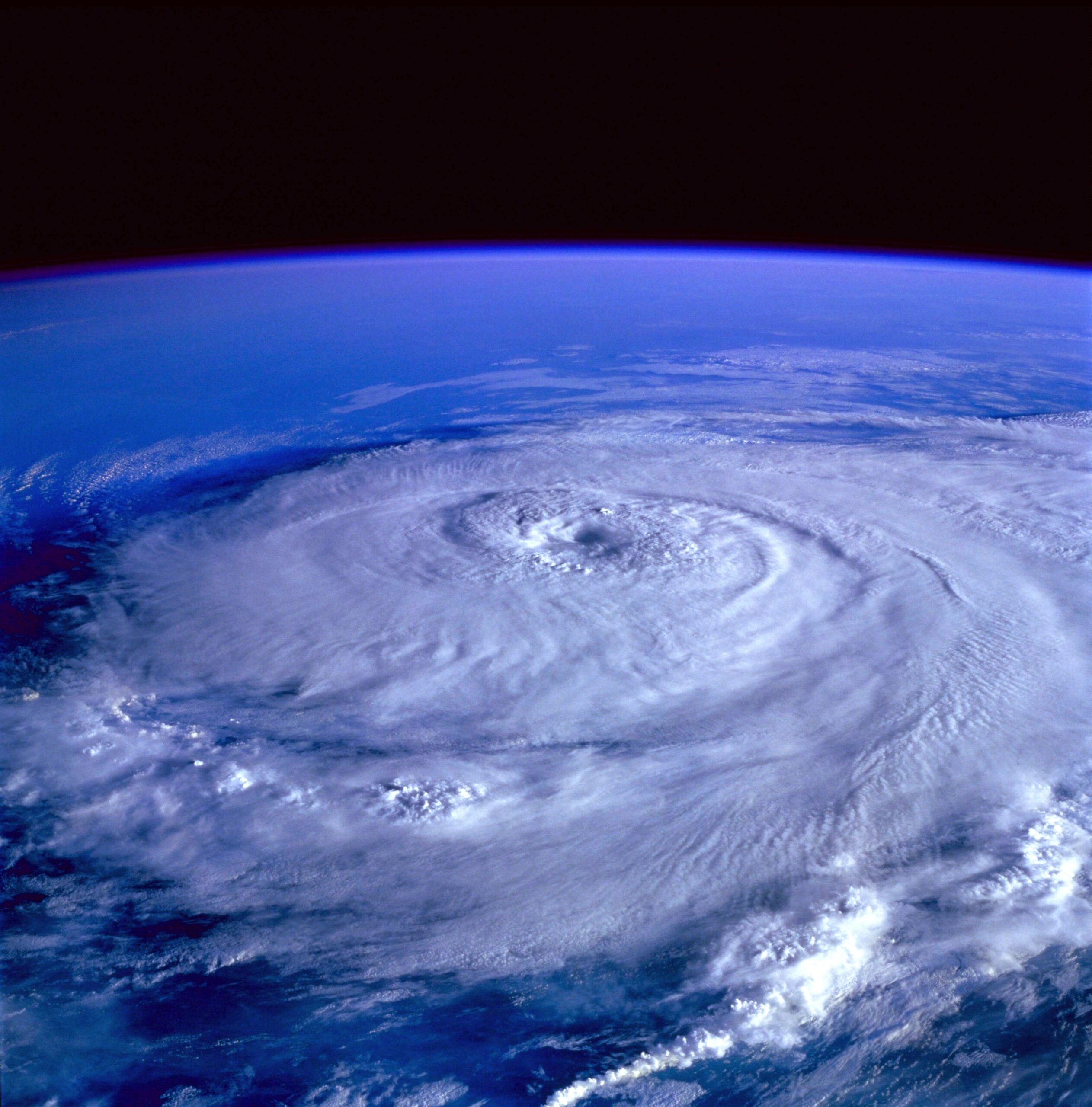
The Bermuda High is a reminder that hurricanes are part of a larger atmospheric pattern. The eye may draw attention on satellite images, but the invisible steering currents around the storm often decide the broad path. Watching those currents makes hurricane forecasts less mysterious. The track is not a guess drawn on an empty ocean. It is the visible result of pressure, wind, timing, and uncertainty working together across thousands of miles.