A river delta looks, at first, like the final chapter of a river’s journey: fresh water spreads out, meets the sea or a lake, and leaves behind a fan of muddy land. But a delta is not a finished shape. It is a moving balance between river water, sediment, tides, waves, storms, sinking land, and human decisions upstream and along the coast. That is why maps of deltas can change over time, sometimes slowly enough to miss from year to year and sometimes quickly enough to reshape farms, wetlands, roads, and neighborhoods within a lifetime.
The basic idea is simple. A river carries sand, silt, clay, and organic material downhill. When the river slows near its mouth, some of that material drops out of the water and builds new ground. The harder part is that the new ground is low, soft, wet, and exposed. A delta keeps changing because it is built by forces that never stop pushing in different directions.
A Delta Begins When a River Slows Down
Rivers are good at carrying material when they have speed. In steep mountains or narrow valleys, water can move gravel and sand with surprising force. Near a coast, the slope usually flattens. The river slows, spreads out, and loses some of its carrying power. Sediment that once stayed suspended in the flow begins to settle.
This settling does not happen evenly. Heavier sand may drop first, while fine silt and clay can travel farther into quiet water. Over many floods, those deposits build bars, mudflats, levees, marshes, and shallow channels. The shape depends on how much sediment the river brings, how strong the waves and tides are, and how deep the receiving water is.
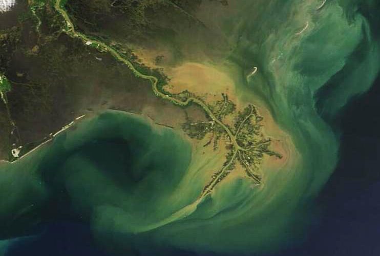
Some deltas stretch outward in long fingers, as the Mississippi River Delta famously has. Others form broader triangular plains, like the Nile Delta. Still others break into a maze of channels, lakes, marshes, and islands. The word delta comes from the triangular Greek letter, but real deltas are often messier than a textbook symbol. Their outlines record a tug-of-war between land-building river deposits and coastal forces that move that material away.
Channels Shift Because Water Looks for Easier Paths
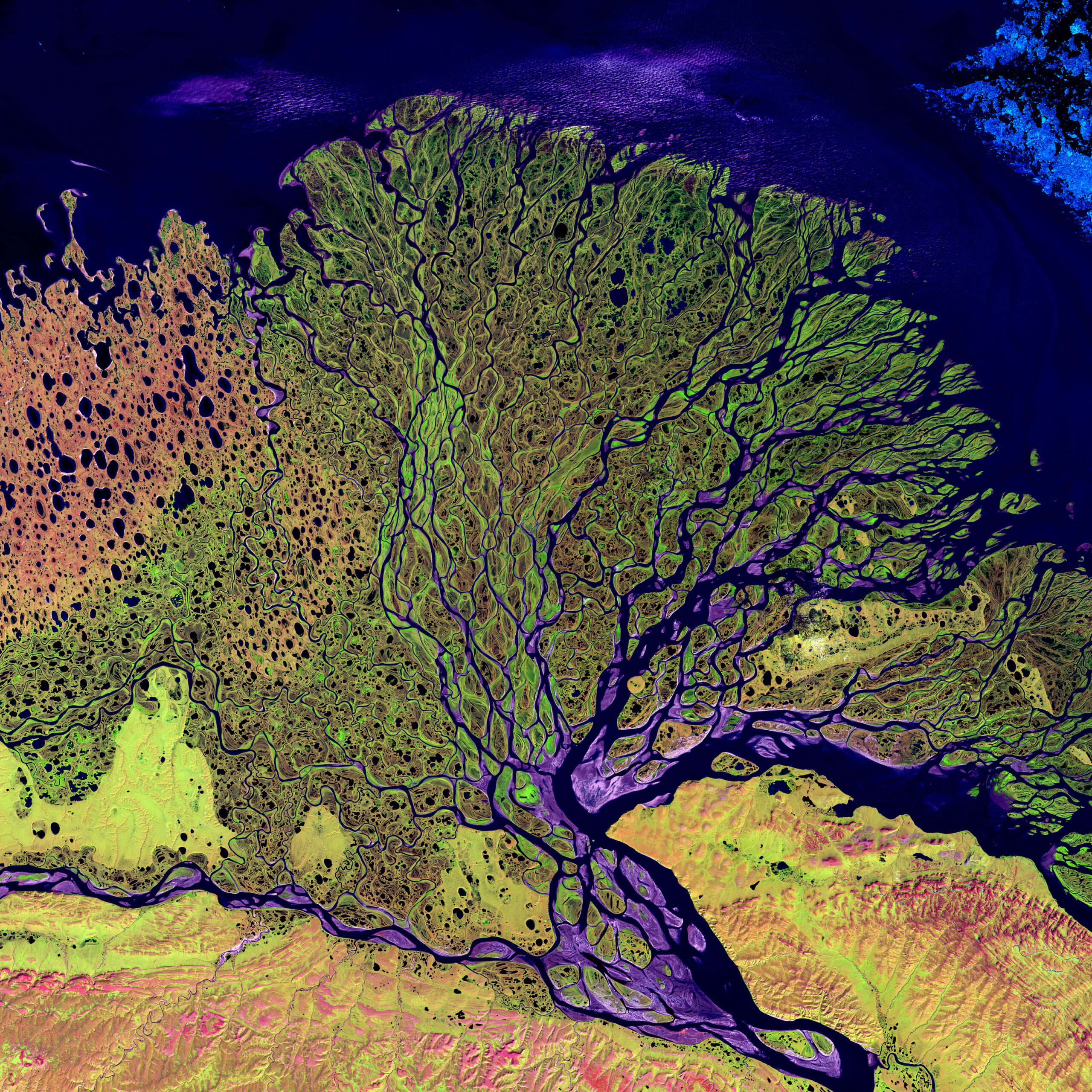
A delta channel is not a fixed pipe. It is more like a path through loose material. As sediment piles up in one channel, the riverbed can become slightly higher than nearby low ground. During a flood, water may spill over a natural levee, carve a shorter route, and begin sending more flow through a new path. Geographers call this process avulsion.
Avulsion can sound unusual, but it is one of the main reasons deltas spread out instead of growing in a single straight line forever. When a channel keeps carrying sediment to one spot, that spot may build outward until the route becomes inefficient. A flood gives the river a chance to switch course. The old channel may shrink, fill with mud, or remain as a smaller distributary, while the new channel begins building a different lobe of the delta.
This is why many deltas contain abandoned bends, old channels, and wetland ridges that no longer match the main river. The landscape keeps a memory of former river paths. From above, a delta can look like a living diagram of past floods, channel switches, and sediment deliveries.
People often try to prevent this movement because farms, roads, ports, and cities need stable ground. Levees can keep a river in place and protect communities from regular flooding. They can also reduce the natural overbank flow that spreads fresh sediment across wetlands. That tradeoff is one reason delta management is so difficult: the same structures that protect people from floods may also limit the land-building processes that help a delta keep up with water.
Waves, Tides, and Storms Push Back Against the River
A delta does not grow into empty space. At the river mouth, coastal water immediately begins reworking what the river delivers. Waves can smooth a delta shoreline and carry sand along the coast. Tides can pull water in and out through channels, widening some passages and filling others. Storms can move huge amounts of sediment in a few days, cutting new inlets, eroding marsh edges, or pushing salty water inland.
Geographers sometimes describe deltas by the force that most strongly shapes them. River-dominated deltas show the river’s sediment supply clearly, often with channels extending seaward. Wave-dominated deltas tend to have smoother shorelines because waves redistribute sediment along the coast. Tide-dominated deltas often develop broad tidal flats and branching channels shaped by daily water movement.
Most real deltas are mixtures. The Ganges-Brahmaputra-Meghna Delta, one of the world’s largest, is shaped by immense river discharge, monsoon flooding, tides, cyclones, and sediment from the Himalayas. The Mississippi River Delta has been shaped by river sediment, levees, subsidence, hurricanes, and coastal erosion. The Nile Delta carries the imprint of ancient river deposition, Mediterranean waves, dense settlement, and reduced sediment delivery since the construction of the Aswan High Dam.
The important point is that a delta’s edge is never just a line between land and water. It is a zone of constant exchange. Mud becomes marsh. Marsh becomes open water. Sandbars become islands. Channels split, close, and reopen. What looks like a stable coast on a small map may be a restless landscape at human scale.
Sinking Land Can Matter as Much as Rising Water
Deltas are especially vulnerable because they are low and built from young sediment. Fresh deposits contain water and organic matter. Over time, those layers compact. In some places, groundwater or oil and gas extraction can make the ground sink faster. This sinking is called subsidence, and it changes the risk equation for delta communities.
Sea level is often discussed as if only the ocean is moving upward. In a delta, the land itself may also be moving downward. NASA’s sea level guidance describes this as relative sea level: the height of the sea compared with the land nearby. If the ocean rises and the land sinks at the same time, people experience a larger increase in flood risk than either process alone would suggest.
Recent research has made this problem harder to ignore. A 2026 Nature study led by L. O. Ohenhen used satellite radar measurements to examine surface elevation change across 40 major river deltas. The researchers found that subsidence is widespread, and in 18 of the 40 deltas studied, the average rate of local land sinking exceeded the rate of regional sea level rise. The study also identified human drivers such as groundwater extraction, reduced sediment supply, and urban expansion as major contributors in different deltas.
That finding does not mean sea level rise is unimportant. It means delta risk has more than one moving part. A community may need to think about global ocean change, local land sinking, storm surge, river floods, and whether the river still brings enough sediment to rebuild low areas. A delta can lose ground not because one force wins, but because several pressures arrive together.
Human Choices Change the Sediment Budget
A delta survives by receiving enough sediment to balance erosion, compaction, and rising water. That balance is sometimes called a sediment budget. When a river carries more useful material than the coast removes, the delta can build or hold steady. When less material arrives, the delta may shrink, sink, or become more vulnerable to storms.
Dams, reservoirs, and river engineering can reduce the sediment that reaches a delta. A dam may be built far upstream for power, water storage, navigation, or flood control, but it can trap sand and silt that once traveled to the coast. Levees can also keep sediment inside the main channel instead of letting floodwater spread it across wetlands. In some cases, the river still carries water to the sea, but much less land-building material reaches the places that need it.
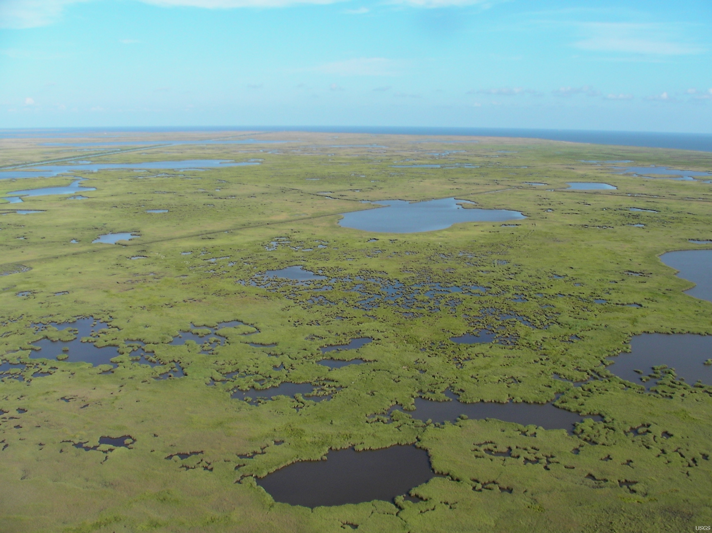
The Mississippi River Delta shows this problem clearly. U.S. Geological Survey work on coastal Louisiana has described how sediment compaction, dewatering, levees, canals, hurricanes, and sea level rise have combined in wetland loss. No single cause explains the whole pattern. The delta is changing because its natural land-building system has been altered while the coast faces stronger pressure from sinking land, storms, and high water.
Other deltas face different versions of the same issue. Some are crowded with cities and farms. Some depend on groundwater pumping that lowers the land. Some are cut by navigation channels or bordered by hard coastal defenses. Some still receive large sediment loads but face powerful tides and storms. The details vary, but the central question is similar: can the delta keep rebuilding itself fast enough?
Why Deltas Matter Far Beyond the Map
Deltas matter because people and ecosystems gather there. Their soils can be fertile. Their wetlands can support fish, birds, shellfish, and storm protection. Their ports connect inland rivers to global trade. Their flat land can make farming and settlement easier, even while that same flatness increases flood exposure.
The 2026 Nature study notes that deltas occupy a small share of Earth’s land surface but support hundreds of millions of people and include major economic centers. That concentration makes delta change a geography issue, an environmental issue, and a human planning issue at the same time. When a delta loses elevation, the effects can reach drinking water, rice fields, roads, fisheries, homes, and evacuation routes.
There is no single solution for every delta. Some places use controlled river diversions to send sediment back into wetlands. Some focus on groundwater management to slow subsidence. Some restore marsh vegetation, protect barrier islands, improve flood warnings, or move the most exposed infrastructure away from the lowest ground. Good decisions depend on knowing which forces are driving change in that particular delta.
The most useful way to understand a river delta is not as land at the end of a river, but as a balance that must be continually renewed. Rivers build. Waves and tides reshape. Storms disturb. Sediment settles. Land sinks. People redirect water and sediment for practical reasons, sometimes with long-term costs. A delta keeps changing because it is made from movement, and its future depends on whether that movement can keep building land as quickly as water and sinking ground take it away.


Add comment