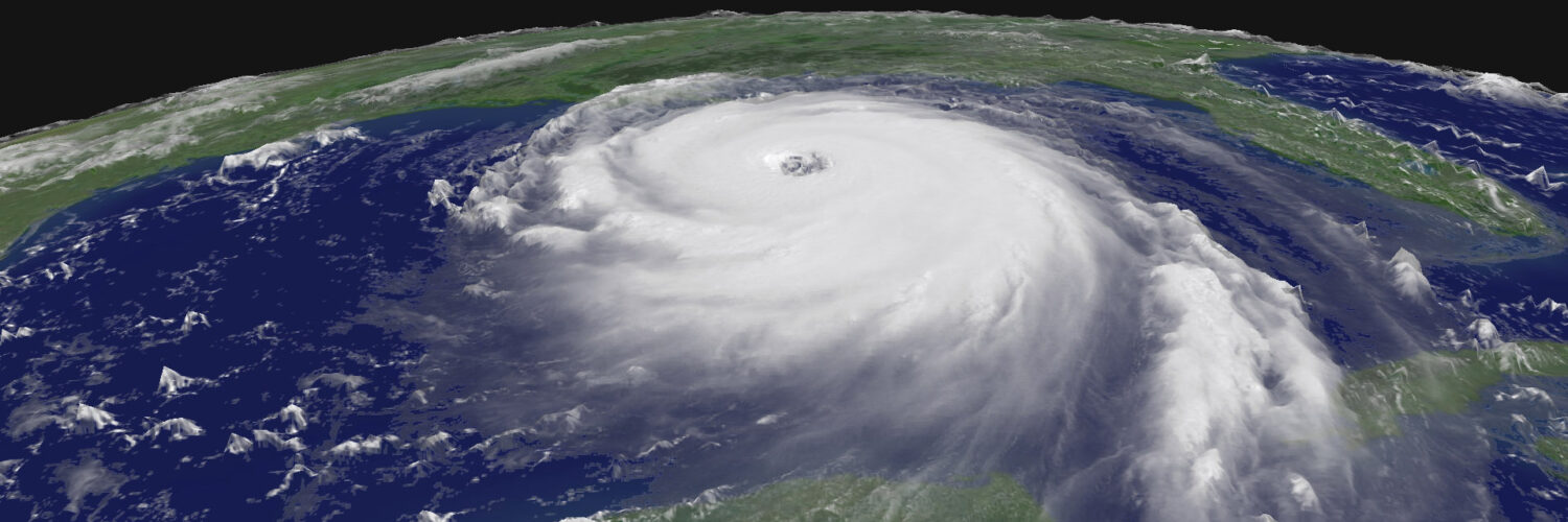
A hurricane does not always strengthen slowly. Sometimes a storm that looked manageable on one forecast cycle becomes much more dangerous by the next day. Meteorologists call this rapid intensification, and it is one of the hardest parts of hurricane forecasting because it compresses the timeline for warnings, evacuations, and preparation. The National Hurricane Center defines rapid intensification as an increase in a tropical cyclone’s maximum sustained winds of at least 30 knots in 24 hours, which is about 35 miles per hour. That may sound like a technical threshold, but in practical terms it can mean the difference between a tropical storm and a hurricane, or between a moderate hurricane and a major one.
Rapid strengthening is not random magic inside a storm. It happens when several pieces of the atmosphere and ocean line up at the same time. Warm water supplies energy, moist air keeps thunderstorms growing, low wind shear lets the storm remain upright, and a well-organized inner core helps the strongest winds tighten around the center. When those ingredients come together, a tropical cyclone can use ocean heat with remarkable speed.
The Engine Inside a Tropical Cyclone
A hurricane is often described as a heat engine, and that comparison is useful as long as it is not taken too literally. The storm draws energy from warm ocean water. Evaporation moves water vapor from the sea surface into the lower atmosphere, and rising air carries that moisture into towering thunderstorms. When water vapor condenses into cloud droplets, it releases latent heat, warming the air column and helping lower the pressure near the storm’s center.
Lower pressure allows surrounding air to rush inward. Because Earth rotates, that inward-moving air curves, building the spinning wind field that defines a tropical cyclone. If the thunderstorms remain organized around the center, the cycle can reinforce itself: lower pressure encourages stronger inflow, stronger inflow brings in more warm moist air, and more thunderstorm activity releases more heat. Rapid intensification is what happens when that feedback loop becomes unusually efficient.
Ocean temperature matters, but the surface temperature alone does not tell the whole story. A storm’s winds stir the upper ocean as it passes. If warm water is only a thin surface layer, the storm can churn cooler water upward and weaken its own fuel supply. If the warm layer extends deeper, the storm can keep feeding on heat even while it mixes the water below. That is why forecasters pay attention not only to sea surface temperature but also to ocean heat content.
Why Warm Water Is Necessary but Not Enough
Very warm ocean water is one of the clearest warning signs that a storm has access to extra energy. The Atlantic hurricane season begins on June 1 and runs through November 30 because that is when ocean and atmospheric conditions are usually most favorable in the basin. During peak season, parts of the Caribbean Sea, Gulf of Mexico, and western Atlantic can hold enough heat to support powerful storms.
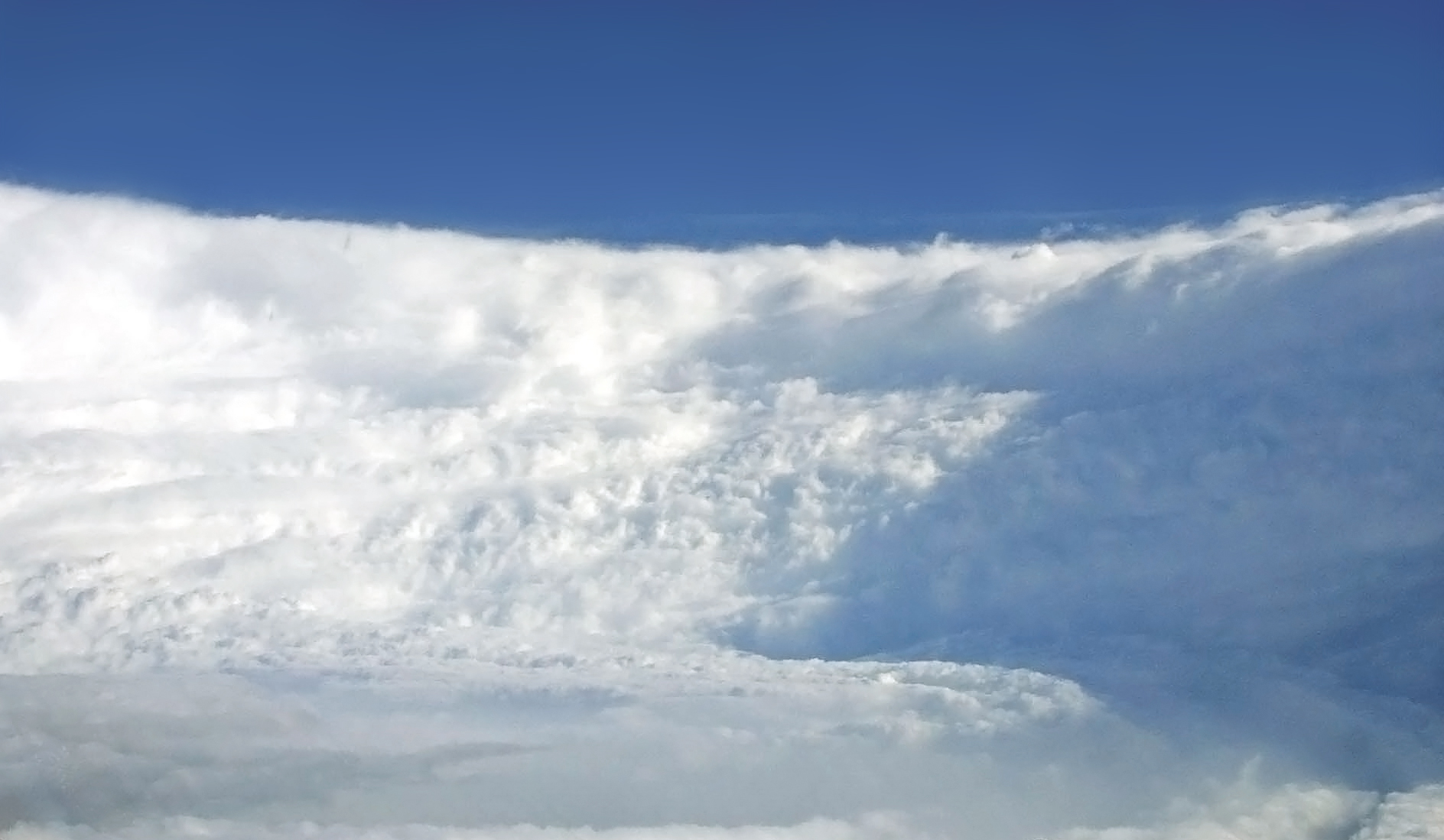
Still, warm water by itself does not guarantee rapid intensification. A tropical cyclone also needs a moist surrounding atmosphere. Dry air can be pulled into the storm and weaken thunderstorms before they can wrap around the center. Strong wind shear can tilt the storm, pushing the upper-level thunderstorms away from the low-level circulation. When that happens, the engine loses its alignment, much like a spinning top that starts to wobble.
Wind shear is especially important. It means wind speed or direction changes with height. A little shear can sometimes help thunderstorms ventilate, but too much shear tears at the storm’s structure. NOAA’s 2026 Atlantic hurricane outlook, for example, pointed to a higher likelihood of El Nino conditions, which often increase vertical wind shear over the Atlantic and can suppress storm development. That does not remove hurricane risk, but it shows why forecasters look at the atmosphere as a whole instead of treating ocean warmth as the only variable.
The strongest rapid-intensification setups usually combine warm deep water, high humidity, low wind shear, and strong upper-level outflow. Outflow is the air spreading away from the top of the storm. If air can leave efficiently above, more air can rise from below, supporting stronger thunderstorms around the center. The storm needs both intake and exhaust.
The Inner Core Can Change Fast
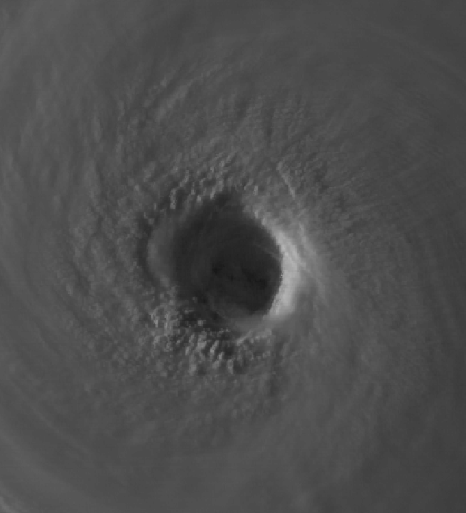
Two storms can sit over similar water and still behave differently because their inner structures are not the same. Rapid intensification often depends on what is happening near the eye and eyewall, the ring of violent thunderstorms surrounding the calmest central region. If thunderstorms wrap tightly and evenly around the center, the pressure can fall quickly and the winds can strengthen sharply.
Forecasters watch for signs that a storm is becoming more symmetric. A ragged storm with thunderstorm bursts on one side may struggle to intensify. A storm with a closed eyewall, deep thunderstorms near the center, and strong spiral rainbands may be ready to strengthen if the surrounding environment stays favorable. Satellite imagery, radar, aircraft data, ocean observations, and computer models all help build that picture.
The inner core can also reorganize in ways that are difficult to predict. Eyewall replacement cycles, for example, happen when a second eyewall forms outside the original eyewall. The inner ring may weaken while the outer one takes over, sometimes causing short-term changes in wind speed while expanding the storm’s wind field. These details matter because the highest wind speed is only one part of hurricane danger. A larger storm can push more water toward the coast even if its peak winds are not increasing every hour.
Why Forecasting Rapid Strengthening Is So Difficult
Hurricane track forecasts have improved greatly over the past several decades, but intensity forecasts remain harder. Track depends heavily on large steering patterns, such as high-pressure ridges and troughs in the atmosphere. Those features are broad enough for models to capture with increasing skill. Intensity depends on smaller details inside the storm and on rapid exchanges between ocean, air, clouds, and rainfall.
A forecast model may correctly show warm water and low shear, yet still miss exactly when the inner core will organize. A storm may also pass over a warm ocean eddy, encounter a pocket of dry air, or experience a brief change in upper-level winds. Small differences can grow quickly. That is why rapid intensification often appears in forecasts as a risk rather than a certainty: the ingredients may be present, but the storm still has to use them in the right way.
NOAA and the National Hurricane Center have invested heavily in improving hurricane intensity prediction. The Hurricane Analysis and Forecast System, often called HAFS, was developed to better represent storm structure, ocean interaction, and intensity changes. Even with better tools, forecasters still communicate uncertainty carefully because a missed rapid-intensification episode can leave coastal communities with less time to respond.
Aircraft observations are one reason forecasts can improve as a storm approaches land. Hurricane hunter aircraft can measure wind, pressure, temperature, humidity, and radar structure inside the storm. Dropsondes released from aircraft fall through the atmosphere and send back data that models cannot get from satellites alone. Those measurements help forecasters see whether a storm is actually organizing or only appears impressive from space.
Why Rapid Intensification Matters Near Land
Rapid intensification is most worrying when it happens close to a coastline. A storm that strengthens far out at sea may still be dangerous to ships and islands, but emergency managers often have more time to adjust forecasts and warnings. A storm that strengthens in the Gulf of Mexico, Caribbean, or near the southeastern United States can change the risk picture quickly for millions of people.
Wind is not the only concern. A rapidly strengthening hurricane can also produce heavier rainfall, stronger storm surge potential, and more severe coastal impacts depending on its size, speed, angle of approach, and local geography. The Saffir-Simpson scale is based on wind, so it does not fully describe water hazards. That is why official forecasts separate wind warnings, storm surge information, rainfall forecasts, and flood watches.
Rapid strengthening also affects human decision-making. People often anchor their expectations to the first forecast they hear. If a storm was described as weak or moderate yesterday, a stronger forecast today can feel surprising even when the science supports it. The safest approach is to follow updated official forecasts rather than treating an early forecast as the final story. Tropical cyclones are living weather systems, not fixed objects moving along a simple path.
The Bigger Lesson in a Changing Climate
Scientists are careful about linking any single storm to climate change, but the physics of hurricane energy is clear: warmer oceans can provide more fuel when other conditions allow storms to use it. NOAA’s Geophysical Fluid Dynamics Laboratory has explained that warmer sea surface temperatures favor hurricane development and intensification, while other factors such as upper-atmosphere warming and wind shear can complicate the outcome. The result is not that every season produces more storms, but that the strongest storms and the fastest strengthening episodes deserve close attention.
Recent research has also examined whether rapid intensification is becoming more common or more extreme in parts of the world. The details vary by basin and time period, and natural climate patterns still matter. For learners, the most important point is that hurricane risk is shaped by interacting systems: ocean heat, atmospheric steering, wind shear, moisture, storm structure, coastal geography, and human preparedness all meet in the final impact.
Rapid intensification turns that complexity into a time problem. The atmosphere and ocean may give a storm an opening, and the storm may take advantage of it faster than people expect. Understanding the process does not make hurricanes less dangerous, but it does make the warnings easier to interpret. When forecasters say a storm could strengthen quickly, they are not being vague. They are describing a real pathway by which warm water, organized thunderstorms, and a favorable atmosphere can change a storm’s future in a single day.


Add comment