
 Akshay Dinesh
A tsunami is not simply a very large version of an ordinary ocean wave. It is a series of long waves created when a large volume of water is displaced suddenly. In deep water, the waves may be low enough to pass beneath a ship almost unnoticed, yet they can cross an ocean at extraordinary speed. Near land, the same energy is compressed into shallower water, producing powerful currents, rapid flooding, and destructive surges. Understanding that sequence explains why a disturbance far offshore can become a disaster at the coast.
What Makes a Tsunami Different From an Ordinary Wave?
Wind creates most of the waves seen at a beach. It transfers energy to the ocean surface, producing waves with relatively short distances between their crests. A tsunami behaves differently because the disturbance moves a much deeper column of water. The word tsunami comes from Japanese words meaning “harbor wave,” but a tsunami is not caused by tides and should not be called a tidal wave.
Tsunami wavelengths can extend for hundreds of kilometers. In the open ocean, a wave may be less than a meter high while moving faster than a passenger jet. NOAA’s historical tsunami data explains that speed depends mainly on water depth: the deeper the water, the faster the wave can travel. As the seafloor becomes shallower near a coast, the wave slows, its wavelength shortens, and its height and currents can increase.
A tsunami also arrives as a train of waves rather than one isolated crest. The first wave is not necessarily the largest, and dangerous currents may continue for hours. At the shoreline, the event may resemble a fast-rising flood, a churning surge, or a wall of turbulent water. The familiar curling wave seen in surfing photographs is not the usual appearance.
How Tsunamis Begin
Most destructive ocean-wide tsunamis begin with large, shallow earthquakes beneath or close to the seafloor. The earthquake must move enough of the seabed vertically to lift or lower the water above it. This is why many strong earthquakes do not produce tsunamis: some are too deep, too small, or involve mainly sideways motion. Subduction zones are especially important because one tectonic plate can become locked against another and then rupture across a broad area.
The Pacific “Ring of Fire” contains many subduction zones, so it produces a large share of the world’s recorded tsunamis. The danger is not limited to the Pacific, however. The 2004 Indian Ocean tsunami began near the Sunda subduction zone west of Sumatra and spread across the basin. Tsunamis have also occurred in the Mediterranean, Atlantic, Caribbean, and in lakes and enclosed bays.
Earthquakes are not the only cause. A landslide can force water outward when rock falls into a bay or when sediment collapses underwater. A volcanic explosion, caldera collapse, or collapsing volcanic flank can do the same. Sudden changes in air pressure can sometimes produce smaller tsunami-like waves called meteotsunamis. Asteroid impacts could generate tsunamis as well, although UNESCO’s Intergovernmental Oceanographic Commission notes that no asteroid-generated tsunami has been recorded in recent history.
Why the Coast Changes the Wave
The approach to shore is called shoaling. As part of a tsunami enters shallower water, friction with the seabed slows it. Waves arriving behind it are still moving faster in deeper water, so the distance between crests contracts and water builds upward. The result is not determined by the earthquake alone. Seafloor shape, coastal slope, reefs, islands, bays, river mouths, and the direction of arrival all influence what happens at a particular place.
Narrow bays and harbors can concentrate water and intensify currents. Low-lying coastal plains allow flooding to travel farther inland, while rivers and streams can carry a surge beyond the open shoreline. A headland may offer little protection because long tsunami waves can bend around coastal features. Two communities only a short distance apart can therefore experience very different water heights and damage.
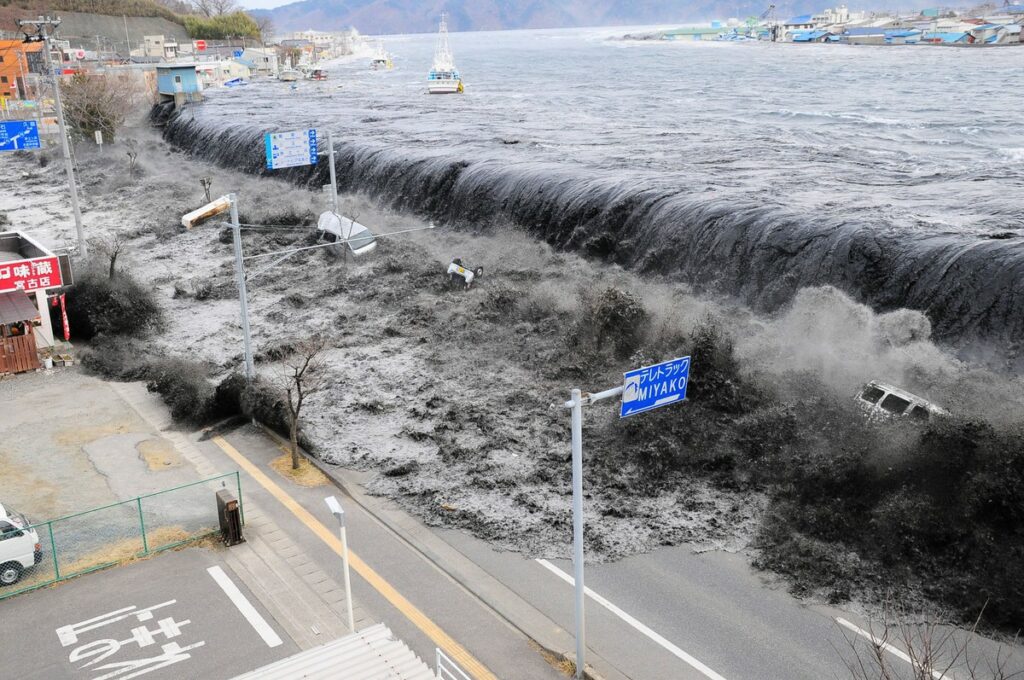
The highest point reached by tsunami water above a reference sea level is called runup. Runup is not the same as the height of a neat breaking wave. It may mark the upper reach of rushing water on a hillside or inside a narrow inlet. Flooding, erosion, strong currents, and debris carried by the water usually cause more destruction than a single wave impact.
What Major Events Reveal
The 2004 Indian Ocean tsunami
On December 26, 2004, a great earthquake off northern Sumatra displaced the seafloor along a long section of the Sunda megathrust. The tsunami crossed the Indian Ocean and struck coastlines from Indonesia and Thailand to Sri Lanka, India, and East Africa. NOAA’s National Centers for Environmental Information records more than 227,000 people killed or missing and more than one million displaced. The disaster exposed major gaps in public awareness and regional warning coverage, leading to a much stronger Indian Ocean warning and mitigation system.
The 2011 Tohoku tsunami
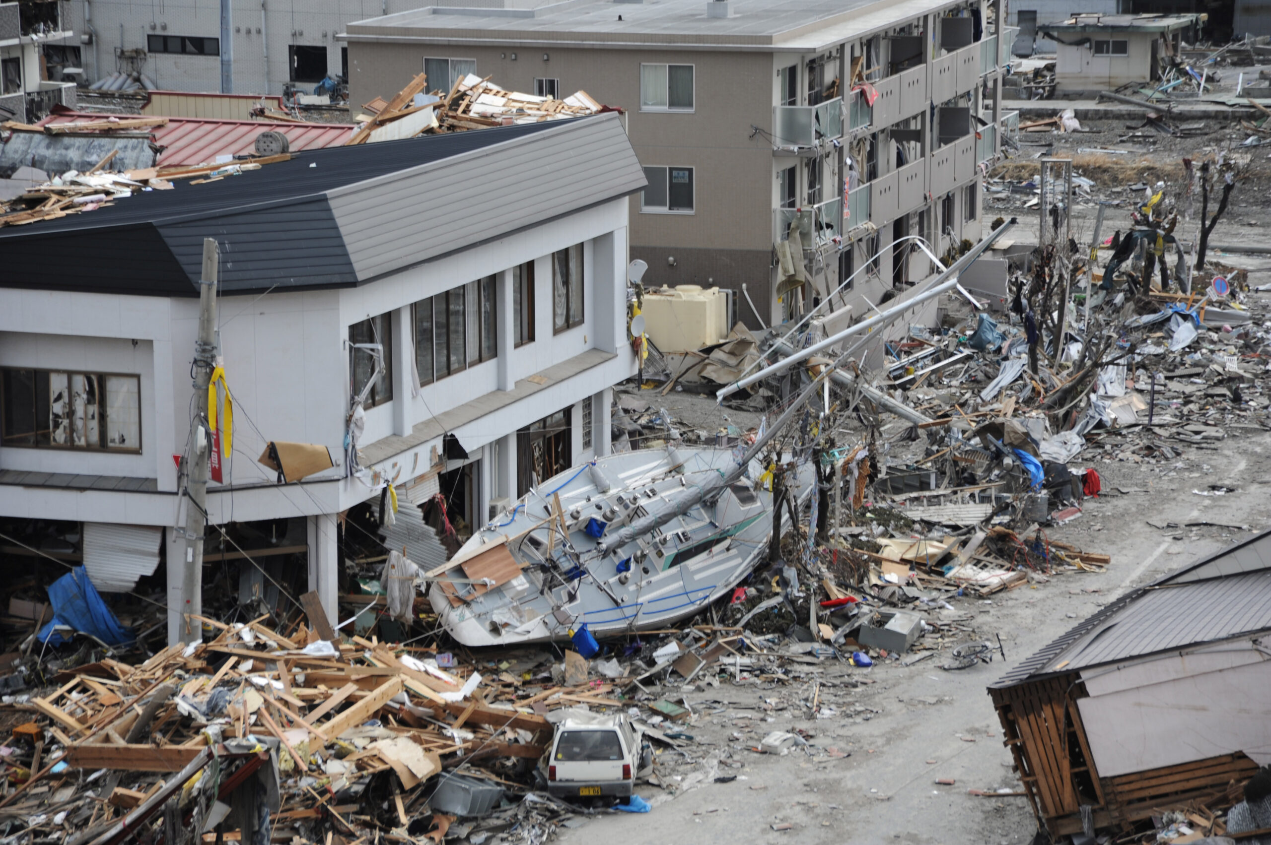
On March 11, 2011, a magnitude 9.0 earthquake off northeastern Japan generated a tsunami that overtopped defenses and flooded wide areas of the Tohoku coast. The water destroyed buildings and transport networks and contributed to the Fukushima Daiichi nuclear disaster by disabling power and cooling systems. Japan had extensive monitoring, seawalls, and evacuation planning, yet the event showed that structural defenses can be exceeded. Evacuation routes, public drills, vertical evacuation buildings, and clear risk maps remain essential alongside engineered barriers.
The 1958 Lituya Bay event
Lituya Bay in Alaska demonstrates how a local landslide can create an extreme runup without producing an equally large ocean-wide tsunami. A magnitude 7.9 earthquake triggered a rock avalanche at the head of the narrow bay. The U.S. Geological Survey reports that water ran up 524 meters on the opposite slope, stripping trees from the mountainside, while a roughly 30-meter wave moved through the bay. The extraordinary 524-meter measurement describes runup beside the impact zone, not a 524-meter wave traveling across the open ocean.
Warning Signs, Damage, and Safer Decisions
Tsunami damage comes from more than water depth. Fast currents can undermine foundations, sweep away vehicles, batter structures with debris, damage ports, and tear apart utilities. Salt water can contaminate wells and farmland. Roads, communications, power, health services, and water systems may fail at the same time, and returning water can be as dangerous as the incoming surge.
Warning centers combine earthquake measurements, coastal water-level gauges, and deep-ocean sensors to estimate whether a tsunami was generated and where it may travel. Forecasts improve as observations arrive, but a nearby tsunami can reach shore before an official alert. Natural warning signs therefore matter. UNESCO-IOC and NOAA emphasize three signals: strong or unusually long ground shaking, a sudden rise or fall of the sea, and a loud roar from the ocean.
If any of those signs occur near the coast, move inland or to higher ground immediately and follow local evacuation routes. Do not go to the shore to watch, and do not wait for a siren when the source may be nearby. Stay out of beaches, harbors, river mouths, and other low-lying coastal areas until officials give the all-clear, because later waves may be larger than the first. In places without nearby high ground, local plans may direct people to a designated vertical evacuation structure.
Communities reduce risk through several layers of protection: hazard maps, warning systems, evacuation signs, drills, land-use planning, resilient buildings, and public education. Seawalls can reduce some impacts, but no wall can guarantee safety against every event. The most reliable approach combines good science with plans people have practiced before an emergency begins.
Living With a Rare but Serious Hazard
Tsunamis are uncommon at any one coastline, but their reach and speed make preparation worthwhile. The chain begins with sudden displacement, continues as long waves cross deep water, and changes sharply as those waves meet the coast. Local geography then determines where water rises, accelerates, and travels inland. Knowing the natural warning signs turns that science into a practical decision: when the ground shakes strongly or the sea behaves strangely, leave the coast quickly and remain away until authorities say it is safe.