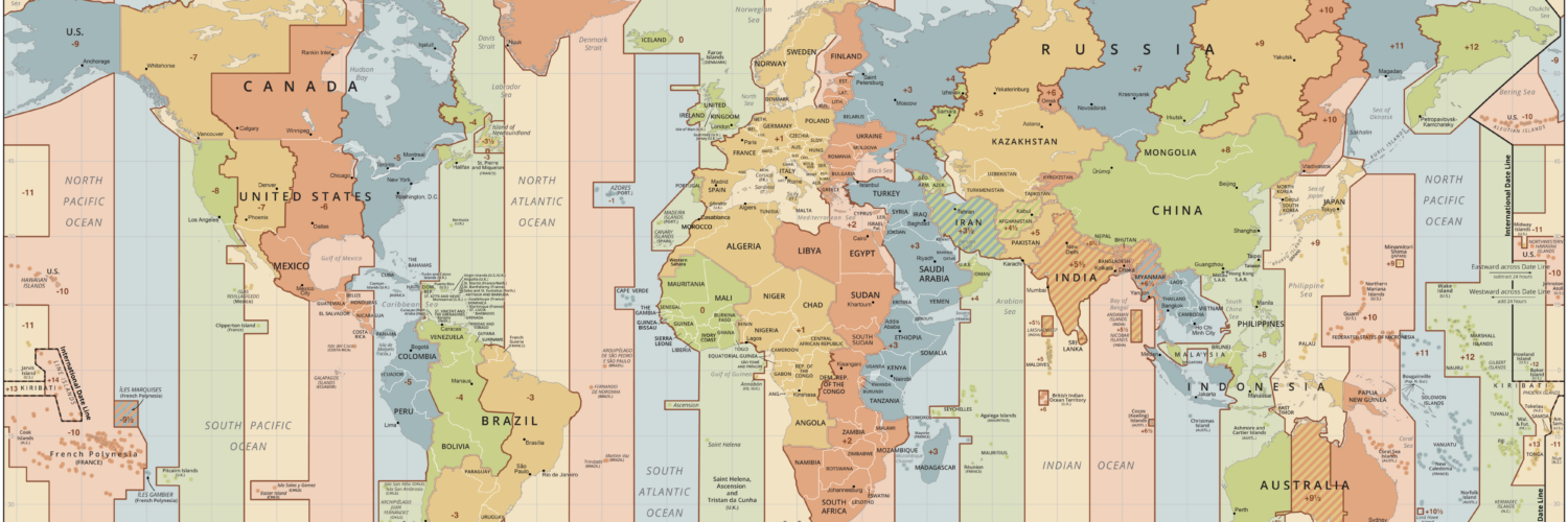
On a simple classroom diagram, time zones look as if they should be clean vertical slices running from pole to pole. Earth turns once every 24 hours, longitude divides the globe into degrees, and 360 divided by 24 gives a neat 15 degrees per hour. That idea is useful, but the real map quickly gets messier. Time zone borders curve around countries, jump over islands, follow state lines, split regions, and sometimes ignore longitude almost completely.
The reason is not that the system failed. It is that clock time has to work for human life. A time zone is partly about astronomy, but it is also about trains, schools, businesses, borders, politics, energy use, travel, and shared daily schedules. The clock on a wall is a compromise between where the sun is in the sky and what a community needs the day to feel like.

The longitude idea is simple, but local life is not
The basic geography starts with rotation. Earth turns eastward, so places farther east see sunrise and noon earlier than places farther west. Before standard time, many towns used local solar time. Noon roughly meant the moment when the sun was highest in the sky. That worked well enough when travel was slow and most people lived by local routines.
Railroads and telegraphs changed the problem. A train schedule cannot easily work if every town sets its clock a few minutes differently from the next one. In the United States, railroads adopted broad standard-time zones in 1883, and the federal Standard Time Act followed in 1918. The U.S. Department of Transportation still has authority over many official time-zone boundary questions, which is why the legal map is not just a scientific diagram. It is a working public system.
The 15-degree rule remains a helpful starting point. Since Earth rotates 360 degrees in about 24 hours, each hour corresponds to about 15 degrees of longitude. A perfectly mathematical world could divide the globe that way. Real countries do not line up that neatly. Cities, provinces, rivers, deserts, mountain ranges, trade regions, and national borders all pull the lines away from a clean grid.
Countries usually want shared clocks more than perfect solar time
The biggest reason time zones bend is political geography. A country may prefer one shared clock so government offices, banks, schools, television schedules, and national transportation systems stay coordinated. China is the clearest example. The country spans a wide range of longitudes, but it officially uses one standard time, China Standard Time, across the mainland. That makes national coordination simpler, even though solar noon arrives much later in the far west than it does near the east coast.
Other places make the opposite choice. The United States, Canada, Australia, Russia, and several other large countries use multiple time zones because a single clock would make local days feel too distorted. If sunrise routinely came near lunchtime in one region, or sunset arrived too early in another, people would feel the mismatch every day. Multiple zones allow large countries to keep clocks closer to local daylight patterns while still grouping areas into broad, predictable regions.
Small countries face a different calculation. Many choose the same time as their neighbors because trade and commuting matter more than exact longitude. A border town may care less about solar noon than about whether schools, offices, ports, and markets open at compatible times on both sides of a boundary. That is why time zones often follow national borders instead of meridians.
Coasts, islands, and borders make the map jagged
Time zone maps look especially irregular around coastlines and island groups. Islands may choose a time zone that helps them connect with a capital city, a major trading partner, a nearby region, or a national identity. The International Date Line has some of the most dramatic bends because island countries may decide that sharing a calendar date with important neighbors matters more than staying close to a straight 180-degree line.
Even within countries, boundaries often follow familiar administrative lines. The U.S. Bureau of Transportation Statistics notes that official U.S. time-zone delineations can follow state or county lines, rivers, and other geographic features as well as longitude. That makes the time-zone border easier for people to understand and enforce. It is simpler to say a county observes Central Time than to ask residents to follow an invisible line crossing farms, roads, or neighborhoods.
Transportation also matters. Airports, bus routes, delivery networks, rail lines, and shipping schedules all depend on predictable timekeeping. A region may be placed in the same time zone as its main economic center even if longitude suggests another choice. The map bends because people move, trade, and communicate through networks that do not always run north and south.
UTC gives the world a reference point
If local time zones are full of compromises, global coordination needs a steady reference. That reference is Coordinated Universal Time, or UTC. NIST and the U.S. Naval Observatory display official U.S. time using UTC as the underlying standard, and UTC is used across aviation, computing, science, navigation, broadcasting, and international scheduling.
UTC does not erase local time. Instead, it gives every local time an offset. Eastern Standard Time is UTC-5, Central Standard Time is UTC-6, and so on. During daylight saving time, many places shift their offset by one hour. That is why a city can be described both by its local clock and by its relationship to UTC.
The Greenwich Prime Meridian helped create the shared reference system behind modern timekeeping. The 1884 International Meridian Conference selected Greenwich as the common zero point for longitude and helped support a world in which navigation and time reckoning could use the same frame of reference. The conference did not magically create every modern time zone, but it helped anchor the global language of longitude and time.
Daylight saving rules add another layer
Standard time is only part of the story. Many places also use daylight saving time, shifting clocks forward for part of the year. That seasonal choice changes the relationship between local time and UTC without moving the place on the map. A city may be UTC-5 in winter and UTC-4 in summer, depending on its rules.
These rules are not universal. Some places use daylight saving time, some do not, and some have changed their rules repeatedly. Arizona, for example, generally stays on Mountain Standard Time, while the Navajo Nation observes daylight saving time. That creates a patchwork that cannot be explained by longitude alone. It reflects law, local preference, climate, history, and practical coordination.
This is one reason computers rely on detailed time-zone databases rather than simple formulas. The IANA Time Zone Database records local time histories, UTC offsets, and daylight-saving rules for representative locations around the world. It has to be updated when governments change boundaries or clock rules. A calendar app that schedules a meeting across countries is quietly depending on years of political and historical timekeeping data.
A time zone is a human map of daylight
The most important thing to remember is that time zones are not merely measurements. They are agreements. Longitude explains why different places experience noon at different moments, but communities decide how to turn that fact into clock time. The result is a map that looks imperfect only if we expect it to be pure geometry.
In practice, the bending lines make sense. A time-zone border may follow a country because people share a government. It may follow a state or county because laws and schedules are easier to apply that way. It may bend around islands because a nation wants to share a date with its neighbors. It may ignore the nearest meridian because trade, travel, or daily life points in another direction.

That is why the time-zone map is both scientific and social. It begins with Earth turning under the sun, but it ends with people trying to live, work, travel, and communicate together. The crooked borders are not mistakes. They are the visible edges of a global compromise between the sky and the clock.


Add comment