The ground under our feet feels solid because human life is brief and rock usually moves slowly. From Earth’s point of view, though, the surface is restless. Continents drift, ocean floors spread, mountains rise, and faults store energy until they suddenly slip. Plate tectonics is the idea that ties those changes together: the outer shell of Earth is broken into large moving pieces, and the places where those pieces meet are where much of the planet’s drama becomes visible.
That movement is not fast in ordinary human terms. The U.S. Geological Survey compares plate motion to the growth of fingernails, though different plates move at different speeds and in different directions. A few centimeters a year sounds tiny, but over thousands, millions, and tens of millions of years, that pace is enough to open oceans, close seas, lift mountain belts, and rearrange maps. The slow motion matters because it is steady, powerful, and almost always building stress somewhere.
Earth’s Surface Is Broken Into Moving Plates
Plate tectonics begins with the lithosphere, the stiff outer layer that includes Earth’s crust and the uppermost mantle. This shell is not one unbroken skin. It is divided into major and smaller tectonic plates that sit above hotter, weaker rock below. The plates include both continental crust, which is generally thicker and less dense, and oceanic crust, which is usually thinner, denser, and younger.
The plates move because Earth is still losing internal heat. Hotter material inside the planet rises, cooler material sinks, and gravity helps pull dense oceanic plates downward where they begin to dive back into the mantle. Scientists still study the exact balance of forces, but the result is clear from GPS measurements, ocean-floor maps, earthquake patterns, and volcanic chains: the plates are not fixed. They are part of a planet that keeps recycling and reshaping its outer surface.
One reason plate tectonics is such a useful idea is that it explains why certain features line up across the globe. Earthquakes do not happen randomly. Most volcanoes are not scattered randomly either. Mountain ranges, deep ocean trenches, mid-ocean ridges, and island arcs often trace the edges of plates. Once those edges are mapped, many seemingly separate facts begin to fit into one larger pattern.
Three Boundary Types Create Different Landscapes
The clearest action happens at plate boundaries. NOAA Ocean Exploration describes three main kinds: divergent boundaries, convergent boundaries, and transform boundaries. Each one is defined by motion. Plates can move apart, move together, or slide past each other. The direction of movement helps determine whether the landscape forms a ridge, a trench, a mountain belt, a volcanic arc, or a long fault zone.
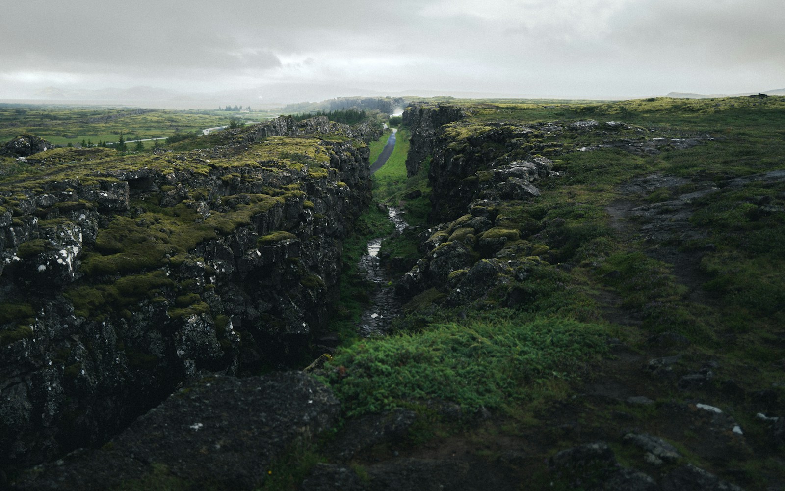
At divergent boundaries, plates pull away from each other. Magma rises into the gap, cools, and creates new crust. This process builds mid-ocean ridges, such as the Mid-Atlantic Ridge, where new seafloor forms as plates separate. In a few places, divergent motion is visible on land. Iceland sits on the Mid-Atlantic Ridge, which is why rift valleys, volcanic activity, and geothermal features are part of its landscape.
At convergent boundaries, plates move toward each other. If an oceanic plate meets a continental plate, the denser oceanic plate usually sinks beneath the lighter continental plate in a process called subduction. That sinking plate can create a deep trench offshore, earthquakes along the boundary, and volcanoes inland where melting helps feed magma. If two continental plates collide, neither plate easily sinks deep into the mantle, so the crust crumples and thickens instead. That kind of collision helps build large mountain ranges.
At transform boundaries, plates slide past each other horizontally. Crust is not mainly created or destroyed there, but stress can build as rough edges lock together. When the locked section breaks loose, the stored energy is released as an earthquake. The San Andreas Fault system in California is a well-known example of transform motion between the Pacific Plate and the North American Plate.
Why Mountains and Trenches Mark Collision Zones
Some of Earth’s tallest and deepest features grow from collisions. The Himalayas formed because the Indian Plate collided with the Eurasian Plate, squeezing and lifting crust over geologic time. This is not like two cars crashing and stopping. The plates continue to push, and the mountain belt continues to change through uplift, erosion, landslides, and earthquakes. A mountain range is less a finished monument than an active result of pressure.
Subduction zones create a different kind of collision landscape. Where a dense oceanic plate bends downward, the seafloor can form a deep trench. The Mariana Trench, the deepest known ocean trench, sits in a subduction setting in the western Pacific. Trenches are not just low places on a map; they are surface clues to a much larger process in which old oceanic lithosphere is being pulled back into Earth.
These collision zones help explain why some coasts are steep, volcanic, and earthquake-prone while others are quieter. Along active margins, such as parts of the Pacific coast of the Americas, oceanic plates interact directly with continental edges or nearby plate systems. Along passive margins, such as much of the eastern coast of North America, the nearest plate boundary is far away in the Atlantic Ocean. The coast still changes through erosion, sea level, storms, and sediment, but it is not sitting on the same kind of active plate edge.
Volcanoes Follow the Heat and the Cracks
Volcanoes are often linked to plate boundaries because boundaries create pathways and melting conditions for magma. At divergent boundaries, plates separate and pressure drops on hot mantle material below. That pressure drop allows some rock to melt, feeding volcanic activity along ridges and rifts. The lava that erupts may build new ocean crust or, in a place like Iceland, add fresh volcanic rock to land.
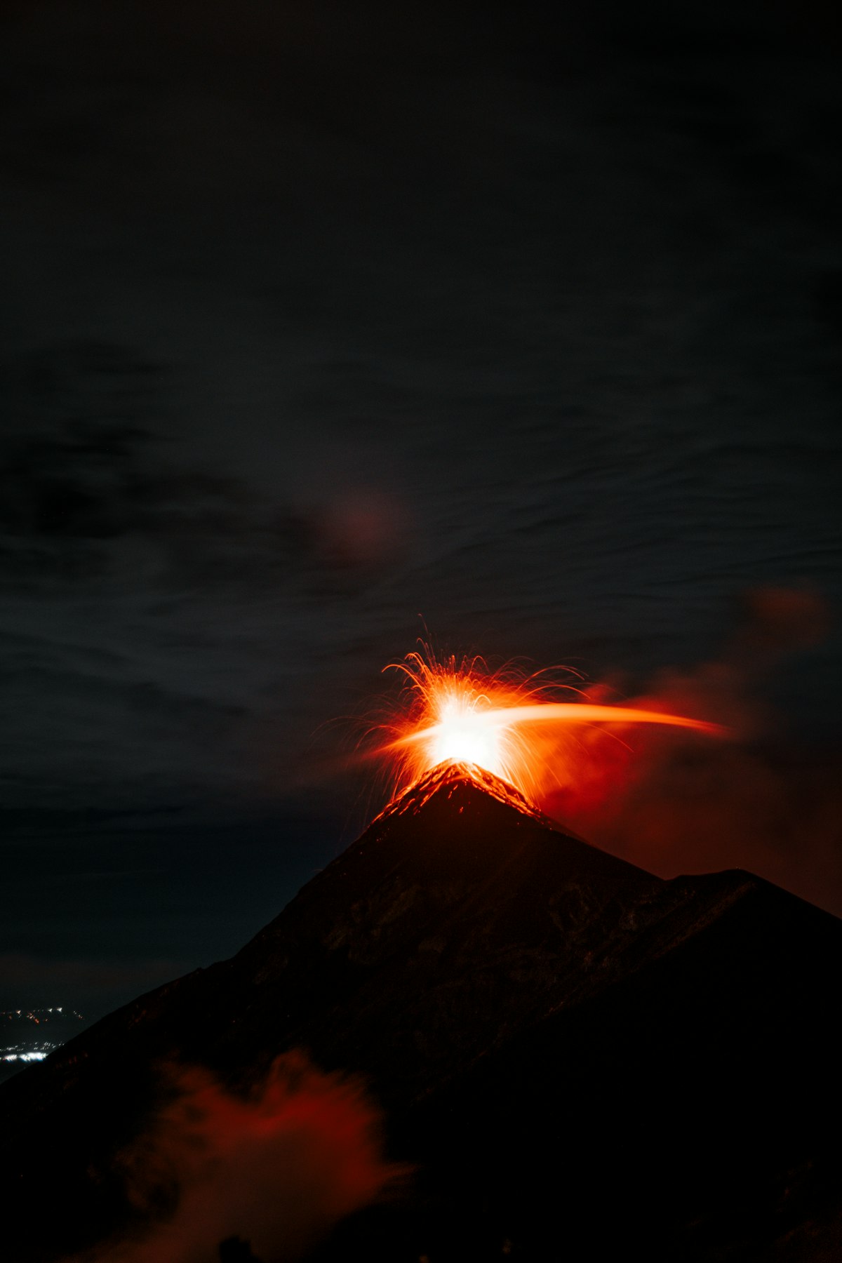
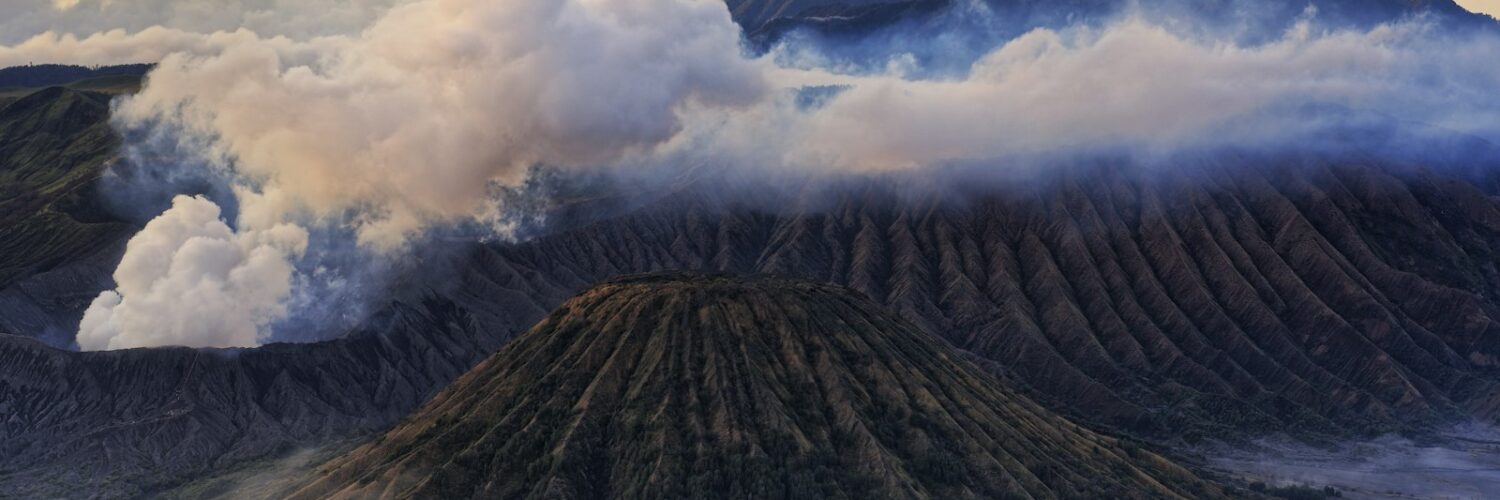
At subduction zones, the process is different. As an oceanic plate sinks, water and other fluids are released from minerals in the descending slab. Those fluids lower the melting point of rock in the mantle above the slab, helping magma form. That magma can rise through the crust and feed volcanoes. This is one reason the Pacific Ocean is ringed by many volcanoes, a pattern often called the Ring of Fire.
Not every volcano sits neatly on a plate boundary. Hot spots, such as the one associated with the Hawaiian Islands, can form volcanic chains within a plate. Even there, plate motion matters: as a plate moves over a long-lived source of hot material, a chain of volcanoes can record the plate’s path. The youngest volcanic activity appears near the active hot spot, while older islands and seamounts trail away from it.
Earthquakes Reveal Where Stress Is Stored
Earthquakes happen when rock breaks or slips along a fault after stress builds beyond what the fault can hold. Plate boundaries are natural places for that stress to accumulate. Plates may be moving steadily overall, but their edges are rough. They can stick for years, decades, or centuries before suddenly jumping. The motion that was delayed then happens in seconds, sending seismic waves through the ground.
Different boundaries produce different earthquake patterns. Transform faults often create shallow earthquakes as plates slide sideways. Subduction zones can produce very large earthquakes because broad areas of one plate may lock against another before slipping. Divergent boundaries also produce earthquakes, usually shallower and often smaller, as crust stretches, cracks, and adjusts around rising magma and new seafloor.

The key point is that earthquakes are not signs that Earth is behaving strangely. They are part of how the crust responds to long-term movement. A fault may seem quiet for a long time, but quiet does not always mean inactive. It may mean stress is building too slowly for people to notice until the fault releases it.
Why Plate Tectonics Matters Beyond Maps
Plate tectonics helps explain many hazards, but it is not only a disaster topic. It is also a framework for reading landscapes. A mountain range can show where crust has been squeezed. A rift valley can show where crust has been pulled apart. A chain of volcanoes can mark subduction or the path of a moving plate over a hot spot. A deep trench can reveal where old seafloor is sinking back into the mantle.
The idea also connects geology to everyday decisions. Engineers, planners, and emergency managers use knowledge of faults, volcanoes, unstable slopes, and coastal subduction zones when they think about building codes, warning systems, evacuation planning, and infrastructure. Plate tectonics cannot say exactly when a specific earthquake will happen, but it can show where the long-term risk is higher and why certain regions need special attention.
For learners, the most useful habit is to look for motion behind the scenery. A landscape may appear still, but its shape often records forces that have been working for immense stretches of time. Plate tectonics turns mountains, islands, trenches, earthquakes, and volcanoes into parts of the same story: Earth is solid enough to stand on, but active enough to keep remaking itself.


Add comment