
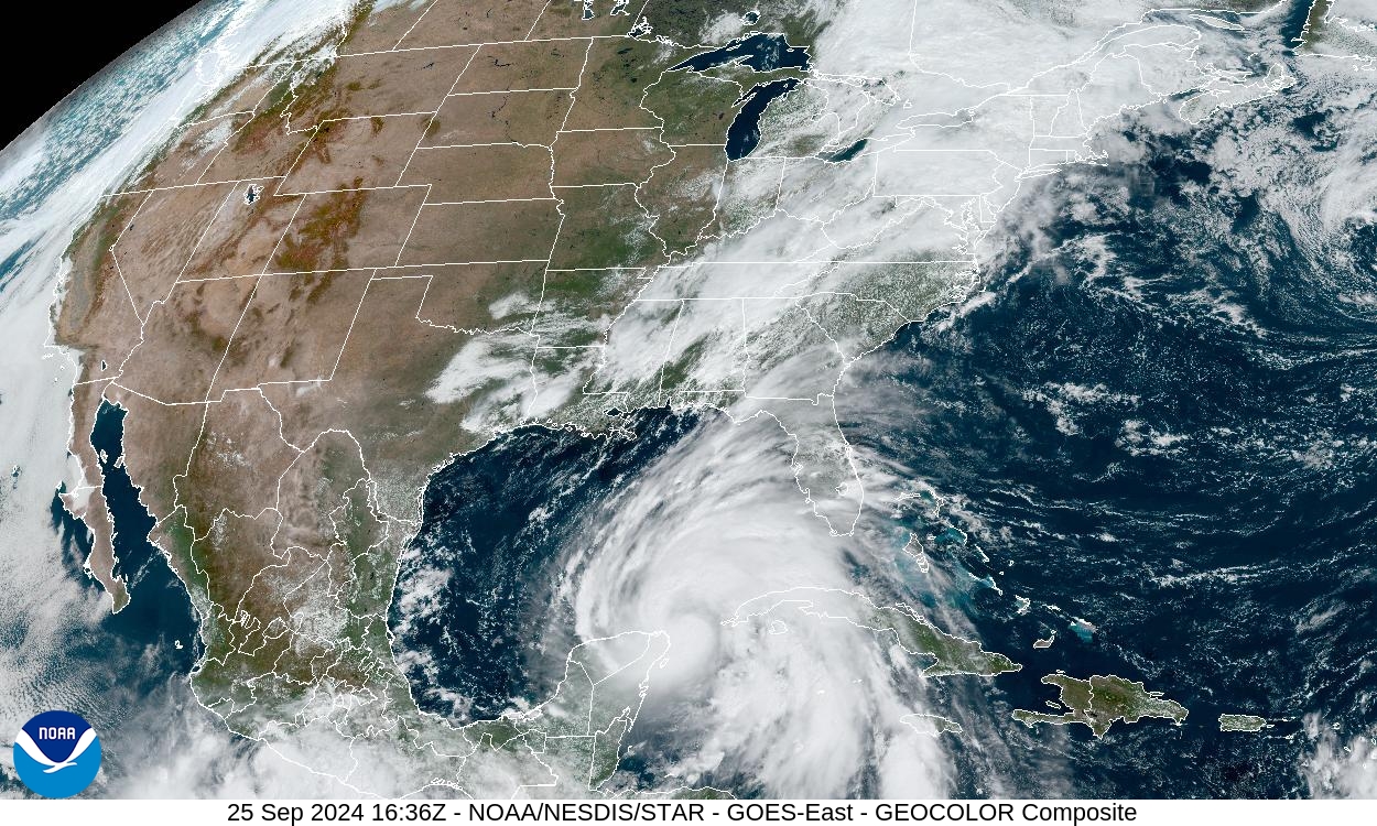
Most hurricane forecasts follow one storm at a time: where it is now, where it may go next, and how strong it may become. The Fujiwhara effect adds a stranger possibility. When two rotating tropical cyclones come close enough, their winds and pressure fields can begin to tug on each other, making the storms move around a shared center instead of behaving like fully separate systems.
The effect is uncommon, but it is not a weather myth. The National Hurricane Center defines it as the tendency of two nearby tropical cyclones to rotate cyclonically about each other. The National Weather Service describes cases in which one storm may orbit another, merge with it, absorb it, or swing away on a changed path. For anyone trying to read a forecast map, the main lesson is simple: a storm’s track is shaped not only by steering winds around it, but sometimes by another storm nearby.
What the Fujiwhara Effect Means
The Fujiwhara effect is named after Japanese meteorologist Sakuhei Fujiwhara, who studied the motion of rotating vortices in the early twentieth century. In weather, a vortex is a rotating system, and a tropical cyclone is one of the largest and most organized vortices on Earth. A hurricane, typhoon, or tropical storm spins because air flows inward toward low pressure and is turned by Earth’s rotation.
When two tropical cyclones are far apart, each one usually follows the larger steering pattern around it. That pattern may include ridges of high pressure, troughs in the jet stream, trade winds, or weaknesses in the atmosphere that let a storm curve north. When two storms move close enough, their own circulations become part of each other’s steering environment. Each storm begins to feel the other as a moving area of low pressure and rotating wind.
The result can look like a slow dance on satellite imagery. The storms may rotate around a point between them, with the smaller or weaker system often making the more obvious loop. If one storm is much stronger, the weaker one may be drawn around it and pulled apart. If the storms are more similar in strength and size, they may orbit for a while, merge, or separate after their tracks have shifted.
Why Two Storms Can Change Each Other’s Tracks
A hurricane does not steer itself in the way a car does. It is carried by the winds around it, especially through a deep layer of the atmosphere. Forecasters often talk about a storm being guided by a ridge, blocked by high pressure, or pulled north by a trough. In a Fujiwhara setup, the neighboring storm becomes another steering influence.
Think of each cyclone as a broad rotating circulation, not just a dot on a map. The winds around one storm can push on the outer circulation of the other. Because both systems are rotating, the interaction is not a straight pull from one center to the other. Instead, the pair can begin rotating around a shared point, called a common center. The exact motion depends on distance, size, strength, forward speed, and the surrounding steering pattern.
This is why the Fujiwhara effect can make forecast tracks look uncertain or unusual. A small change in one storm’s speed or strength may change how strongly it interacts with the other. If one system weakens into a disorganized low, the interaction may fade. If both remain compact and close, the rotation around the common center may become easier to see. The effect can shift a track by enough to matter, even when it does not create one giant storm.
Satellite loops are often the best way to recognize the pattern. On a still map, two storms may simply look close together. In motion, their cloud shields and centers may reveal whether they are rotating around each other, stretching apart, or being pulled into a merger.
What Can Happen When Storms Interact
There is no single Fujiwhara outcome. One possibility is a temporary orbit. The storms rotate around each other for a period, then separate as the larger atmosphere takes over again. This can leave both systems on tracks that differ from the simpler paths they might have taken alone.
A second possibility is absorption. If one cyclone is stronger, larger, or better organized, the weaker system may be pulled into its circulation. The weaker storm can lose its identity as dry air, wind shear, or the stronger storm’s circulation disrupts it. This does not always mean the surviving storm becomes dramatically stronger. Sometimes the merger injects messy air and energy into the larger system rather than neatly feeding it.
A third possibility is a merger between storms of more comparable strength. The National Weather Service points to Hurricanes Hilary and Irwin in the eastern Pacific in 2017 as an example in which two hurricanes interacted and merged over the ocean. These cases are visually striking because satellite imagery can show two organized circulations drawing together, but they are also scientifically complicated. Merging storms can reorganize, weaken, or change structure depending on ocean heat, wind shear, moisture, and the arrangement of their inner cores.
Sometimes the most important outcome is not merger at all, but track change. One storm may pull another farther west, slow it down, or help it curve away. That matters because a forecast track is not just a line on a map. It affects when watches and warnings may be issued, which coastal areas prepare, and where rain, wind, surf, and surge hazards may become more likely.
Why the Effect Is Hard to Forecast
Forecast models already have to solve a difficult problem: represent the atmosphere, ocean, and storm structure well enough to project future motion. The Fujiwhara effect adds another layer because the model must handle two compact, rotating systems and their surrounding environment at the same time. If the model places one storm slightly too far north, too weak, or too fast, the projected interaction can change.
Distance is especially important. Two storms that appear close on a basin-wide map may still be too far apart for a strong interaction. If they move closer, the outer wind fields may begin to overlap more meaningfully. The size of each storm matters too. A broad tropical cyclone can interact across a larger area than a tiny compact one, even if their centers are not extremely close.
Intensity also matters, but not in the simple way people sometimes expect. A stronger storm is not automatically the only one that controls the interaction. The surrounding steering pattern may still dominate both systems, especially if a ridge or trough is strong. A weaker storm may also be shallow, meaning it is steered by lower-level winds rather than the deeper layer that moves a hurricane. That vertical structure can change how the two systems respond to each other.
This is one reason forecasters look beyond a single model run. They compare satellite trends, aircraft data when available, ensembles, and official forecast reasoning. NOAA’s 2026 Atlantic hurricane outlook also notes that seasonal outlooks are not landfall forecasts. A season can be below normal overall and still produce a storm that matters, while a rare interaction can still become relevant if two systems happen to form close enough.

How to Read Forecasts When Two Storms Are Nearby
When two tropical systems appear on the same map, the first step is to avoid assuming that they will merge. Many storms never get close enough or organized enough for a strong Fujiwhara interaction. Some are separated by dry air, hostile wind shear, land, or steering currents that pull them apart before the effect becomes important.
The second step is to watch the official forecast discussion, not just the cone or a social media map. Forecast discussions often explain whether nearby systems are expected to interact, whether model guidance is struggling, and which environmental features are steering the storms. A colorful model image may show an eye-catching loop, but the official reasoning tells readers how much confidence forecasters actually have.
It also helps to separate track from hazards. The Fujiwhara effect is mostly about motion, but people experience storms through wind, rain, flooding, surf, and surge. A storm that curves away can still create dangerous waves. A weaker storm absorbed by a larger one may still contribute moisture. A track that shifts offshore may reduce one risk while increasing another for a different coastline.
The phrase can sound dramatic, but the best use of the Fujiwhara effect is practical. It reminds us that tropical cyclones are not isolated symbols on a map. They are moving, rotating systems embedded in a larger atmosphere, and sometimes they are close enough to become part of each other’s story. That is what makes hurricane forecasting difficult, fascinating, and worth reading with patience.


Add comment