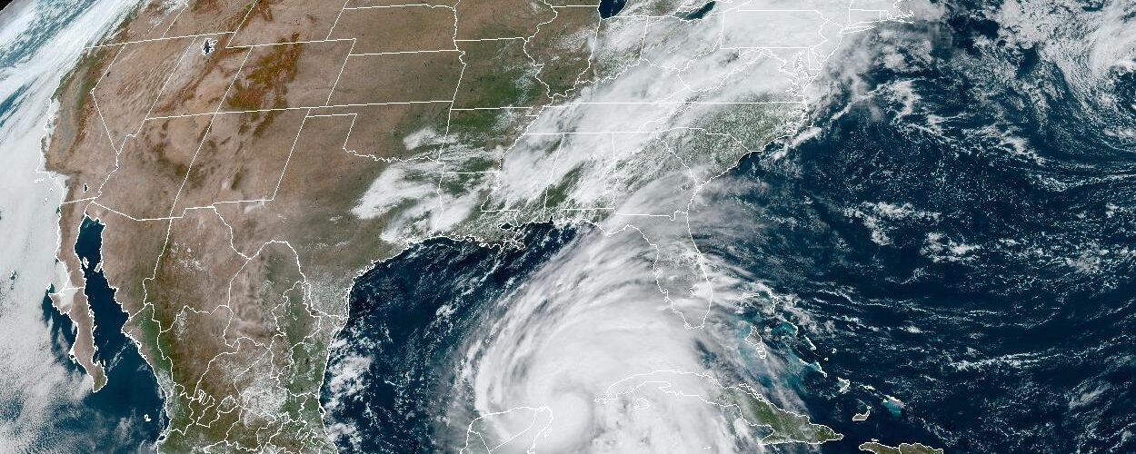
On a weather map, the Gulf of Mexico can look like a warm bowl of water waiting under the path of tropical storms. That picture is partly right, but it is incomplete. Hurricanes do not simply check whether the surface feels warm and then decide how strong to become. They respond to a deeper supply of heat, the structure of the atmosphere above them, and the way ocean currents move warm and cool water around beneath the clouds.
One of the most important ocean features in the Gulf is the Loop Current, a ribbon of warm water that enters from the Caribbean, bends northward into the Gulf of Mexico, then turns east and exits near Florida. During some seasons it reaches far into the Gulf. At other times it stays more compact or sheds warm eddies that drift away like spinning pools of heat. For hurricane forecasters, that shape matters because the current can change how much energy a storm can draw from the ocean before it reaches land.
What the Loop Current Is
The Loop Current begins with warm Caribbean water flowing through the Yucatan Channel, the passage between Mexico’s Yucatan Peninsula and Cuba. From there, the current pushes into the Gulf of Mexico, curves eastward, and leaves through the Florida Straits. Once it exits, it becomes part of the Florida Current and later helps feed the Gulf Stream along the Atlantic coast.
Its path is not fixed like a road on a map. Sometimes the current forms a tight arc near the southern Gulf. Sometimes it stretches northward, creating a long loop that reaches closer to the central Gulf. When the loop becomes extended, it can pinch off a large warm-core eddy. That eddy may drift westward or northwestward, carrying deep warm water with it even after it separates from the main current.
That moving shape makes the Loop Current different from a simple patch of warm surface water. It is not just warm at the top. It can carry warmth downward through a deeper layer of the ocean, which gives storms a larger energy reservoir to work with. NASA and ocean scientists often describe this using tropical cyclone heat potential, a measure that looks beyond the surface and asks how much warm water is stored below.
Why Deep Warm Water Matters
A hurricane acts like a heat engine. Warm ocean water evaporates, adding water vapor to the air. When that vapor rises and condenses inside thunderstorms near the storm’s center, it releases heat, lowers pressure, and helps the winds tighten around the eye. NOAA’s Atlantic Oceanographic and Meteorological Laboratory explains that tropical cyclones need warm ocean water at the surface and enough warmth below the surface to keep feeding the storm.
The depth is the key. A storm’s winds churn the sea as it passes. If the warm layer is shallow, that churning can pull cooler water up from below. The sea surface cools, evaporation weakens, and the storm may lose part of its fuel supply. If the warm layer is deep, mixing does not cool the surface as much. The hurricane can keep drawing heat even while its own winds are stirring the ocean.
The Loop Current and its warm eddies are important because they can create exactly that kind of deep warm layer. A storm crossing ordinary warm surface water may strengthen, but a storm crossing deep ocean heat may have a better chance of intensifying rapidly, if the atmosphere also cooperates. Low wind shear, moist air, and a well-organized inner core still matter. The ocean is not the only ingredient, but it can be the ingredient that prevents a storm from running out of fuel.
How the Current Has Shown Up in Real Storms
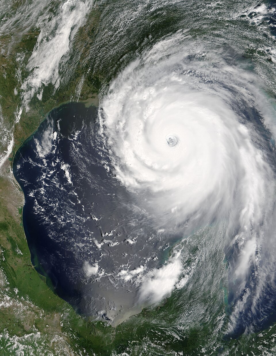
The Loop Current became part of public hurricane discussion after several destructive Gulf storms intensified over deep warm water. NASA’s ocean-surface topography work has pointed to Hurricanes Katrina and Rita in 2005 as clear examples. Both storms strengthened to Category 5 while passing over the Loop Current or a warm ring, then weakened later after moving away from the deepest heat.
That pattern does not mean the Loop Current “causes” a hurricane. A tropical storm must already exist, and the atmosphere must allow it to organize. But the current can help explain why some Gulf storms find extra energy at a dangerous moment. If a storm is already well built, deep warm water can make the difference between steady strengthening and a sharper jump in intensity.
Recent research has also shown that the current’s influence is not always as simple as “more Loop Current, stronger storm.” A 2025 University of South Florida study on Hurricane Ian described how conditions on the West Florida Shelf helped keep subsurface waters unusually warm before Ian’s 2022 landfall. In that case, researchers found that the Loop Current did not reach a region near the Dry Tortugas where it can help trigger upwelling of cooler water. Without that cooling process, warm shelf waters persisted through summer, giving Ian more heat to draw from as it approached Florida.
That finding is useful because it reminds readers that ocean currents can feed storms in more than one way. Sometimes a current directly carries deep warm water under a hurricane. Sometimes its position changes whether nearby shelf waters cool down or stay warm. In both cases, forecasters need more than a surface temperature map to understand the danger.
How Scientists Track Ocean Heat
Forecasters watch the Loop Current with satellites, buoys, floats, ocean models, and measurements from research programs. Satellites can estimate sea surface height, which helps reveal warm-core features because warm water expands and can make the ocean surface sit slightly higher. Other instruments measure temperature and salinity through the water column, showing whether heat is shallow or deep.
Sea surface temperature is still useful, but it can be misleading by itself. Two parts of the Gulf may have similar surface temperatures while holding very different amounts of heat below. One area may cool quickly when storm winds mix the water. Another may stay warm because the heat extends far enough downward. Tropical cyclone heat potential helps forecasters see that difference.
This is one reason intensity forecasting is harder than track forecasting. A storm’s path can often be predicted with improving confidence several days ahead because large atmospheric steering patterns are visible. Intensity depends on smaller, fast-changing details: eyewall replacement cycles, dry air, wind shear, thunderstorm bursts, ocean mixing, and the heat content under the storm. The Loop Current is only one piece, but it is a piece that can matter greatly in the Gulf.
Why It Still Matters in a Quieter Season
NOAA’s 2026 Atlantic outlook called for a higher chance of a below-normal season, largely because a developing El Nino pattern was expected to increase wind shear over parts of the Atlantic. That kind of seasonal outlook is useful, but it does not promise safety for any single coastline. A quieter season can still produce one damaging storm, and a storm that forms close to the Gulf Coast may leave less time for preparation.
The Loop Current is part of that risk because it affects what happens after a storm already exists. A season may have fewer named storms overall, yet one storm can still cross deep Gulf heat under favorable atmospheric conditions. If that happens near land, rapid intensification becomes especially concerning because communities may have to make decisions while the forecast is changing quickly.
This is also why hurricane categories, while familiar, do not tell the whole story. Stronger winds are dangerous, but storm surge, rainfall, inland flooding, and tornadoes can cause major harm even when a storm is not at the highest category. The Loop Current mainly concerns intensity, but the practical lesson is broader: ocean heat can change the forecast, and people near the coast need to follow official updates rather than relying on early assumptions.
The Bigger Lesson Hidden Under the Water
The Loop Current is a good example of how geography and physics meet inside weather. A current that begins in the Caribbean can shape risk along the Gulf Coast. A warm eddy that looks invisible from shore can help a storm hold energy. A small shift in where the current flows can change whether shelf waters cool or stay unusually warm.
For learners, the most important idea is not that every Gulf hurricane will explode in strength over the Loop Current. Many do not. The better lesson is that hurricanes respond to layered conditions. Surface warmth, deep ocean heat, wind shear, moisture, storm structure, and timing all work together. When several of those pieces line up, a storm can change faster than people expect.
That is why scientists keep improving ocean observations in the Gulf of Mexico. The better they can measure heat below the surface, the better forecasters can judge whether a storm is likely to weaken, hold steady, or intensify. The Loop Current may be hidden under waves and clouds, but during hurricane season it can become one of the most important features on the map.


Add comment