
 Akshay Dinesh
Near the equator, on one of New Guinea’s highest mountain ridges, pale fragments of ice still cling to the rock. Yet the most important change is not simply that the ice has become smaller. The remaining patches near Puncak Jaya are now so thin, broken apart, and starved of lasting snow that they no longer move like active glaciers. A glacier can survive only by gaining snow and slowly flowing under its own weight; when both processes fail, what remains is better understood as stagnant, relict ice.
That threshold makes Puncak Jaya a particularly clear example of how a glacier ends. New Landsat imagery released by NASA Earth Observatory in November 2026 shows scattered remnants where connected ice covered several ridges in 1988. The images capture a physical transition that has unfolded for generations: Indonesia still has high-mountain ice, but the functional life of its last glaciers is effectively over.
A rare glacier system beside a warm ocean
Puncak Jaya rises to 4,884 meters, or 16,024 feet, in the Sudirman Range of Indonesian Papua. Its position is remarkable. The mountain lies only about four degrees south of the equator and beside the western Pacific warm pool, the planet’s largest region of persistently warm ocean water. At sea level, this is an intensely tropical environment. Ice could remain year-round only because the mountain reaches into cold, high air.
Tropical glaciers are not simply any glaciers in a warm country. Glaciologists generally use the term for ice within the astronomical tropics that is also influenced by the movement of the Intertropical Convergence Zone and experiences relatively little seasonal change in temperature. Most tropical glacier ice is in the Andes. Smaller remnants survive in East Africa, while Puncak Jaya held the last such ice in the western Pacific warm pool.
The setting makes the glaciers unusually sensitive. In a mid-latitude mountain range, a cold winter may build a deep seasonal snowpack that feeds the ice through summer. Near Puncak Jaya, the difference between snowfall and rain can depend on a small shift in the freezing level. When the freezing level rises above the summit area, precipitation that might have protected and replenished the glacier falls as rain instead.
What the satellite record reveals
Historical maps, expedition photographs, and modern satellite measurements all tell the same broad story. A 2025 study led by David Ibel reconstructed glacier outlines back to about 1850 and found that more than 99 percent of the former area had disappeared by 2024. The study measured just 0.165 square kilometers of ice in 2024, less than one percent of the estimated mid-nineteenth-century extent. It also found that the remaining area had fallen by about 65 percent since 2018.
A separate 2026 analysis led by Francine Hematang used four decades of Landsat imagery. That team estimated that the wider Puncak Jaya and Puncak Idenburg glacier area declined from 7.46 square kilometers in 1980 to 0.19 square kilometers in 2024, a loss of about 97 percent. Different studies can produce slightly different totals because they use different dates, image resolutions, boundaries, and uncertainty methods. The disagreement is small beside the unmistakable scale of the retreat.
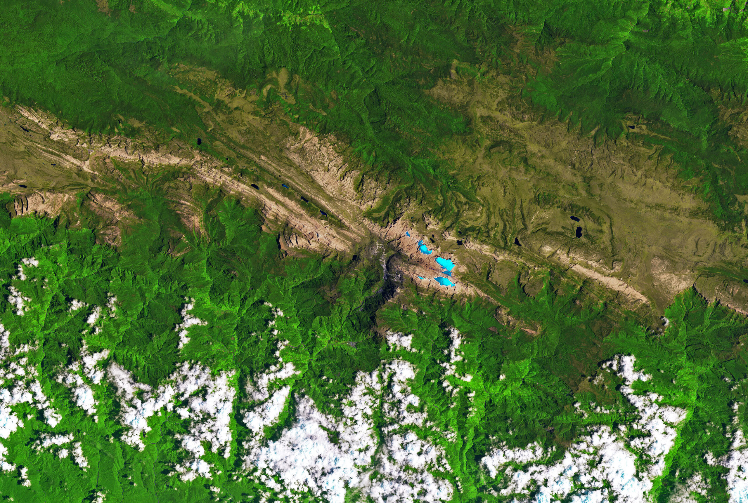
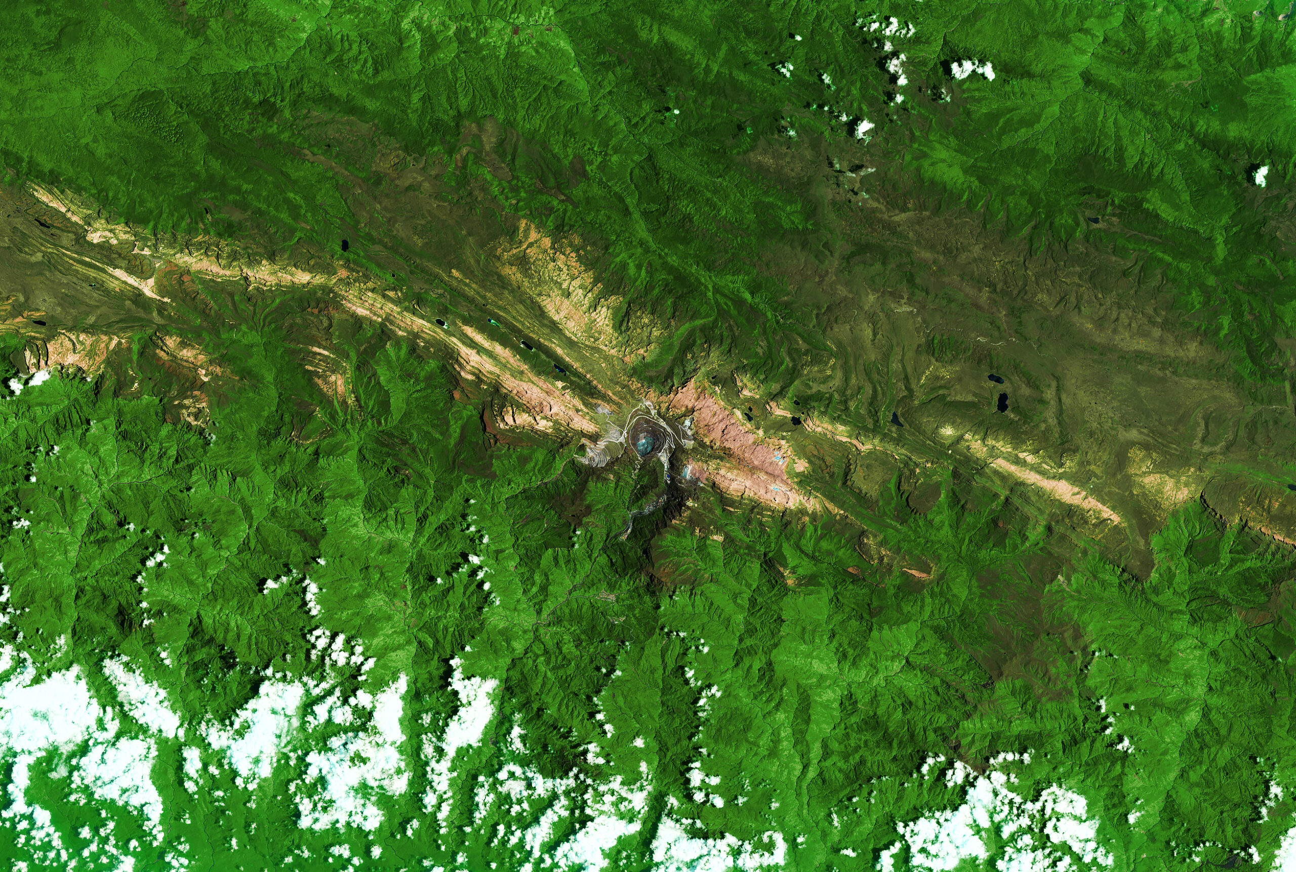
NASA’s new comparison makes the recent change easy to see. In 1988, about 4.31 square kilometers of glacier ice covered several ridges in the scene. By September 2025, satellite and aerial observations indicated that roughly 0.09 square kilometers remained, about two percent of the 1988 area. An aerial survey planned for December 2026 should refine the latest estimate, so the precise amount of surviving ice is still provisional.
Thickness measurements reveal another part of the loss. At a monitoring site on East Northwall Firn, the ice was about 32 meters thick in 2010 and only four meters thick in 2023, according to climate scientist Donaldi Permana of Indonesia’s Agency for Meteorology, Climatology, and Geophysics. By November 2024, the ice at that site had disappeared. A glacier can shrink across a map and thin vertically at the same time; area alone does not show how little volume may be left.
When a patch of ice stops being a glacier
A glacier is not defined by whiteness, permanence, or size alone. It is a body of ice formed on land from accumulated snow that deforms and flows under gravity. The motion may be too slow to notice without careful measurements, but it is essential. The weight of overlying ice causes deeper ice to deform, while the glacier may also slide over its bed.
That motion depends on a continuing mass balance. In an accumulation zone, snowfall adds more material than melting, evaporation, and other losses remove. Lower on the glacier, an ablation zone loses more than it gains. A glacier can retreat even while ice inside it continues to flow downhill; its front moves backward when melting removes ice faster than flow replaces it.
Puncak Jaya’s remnants have crossed a more fundamental boundary. They are too small and thin to generate meaningful flow, and snow no longer persists on the surrounding bare rock long enough to rebuild them. Researchers therefore describe the fragments as stagnant or relict ice. The distinction explains how ice can remain after a glacier has functionally disappeared.
Fragmentation hastens the transition. When one connected ice body breaks into several pieces, more of its perimeter is exposed to warm air, rain, and heat from nearby rock. Dark bedrock absorbs more sunlight than fresh snow and can warm the edges of the ice. Each split reduces the body’s ability to sustain the thickness and continuity that glacier flow requires.
Why warming and El Niño hit this ice so hard
Long-term atmospheric warming sets the direction of change. The 2025 study reported that temperatures at glacier altitude rose by about 1 degree Celsius between 1972 and 2000. By the late 1990s, average daily temperatures roughly 300 meters below the glaciers had almost no chance of remaining below freezing. At the highest ice, freezing conditions increasingly occurred only for a few nighttime or early-morning hours.
El Niño can add a sharp pulse to that background warming. During an El Niño event, changing ocean and atmospheric circulation can raise temperatures around Puncak Jaya and lift the altitude at which air is cold enough for snow. More rain and less snow means the glacier loses both new material and a reflective shield. Bare or dirty ice absorbs more solar energy than fresh snow, accelerating melt.
The 2015-2016 El Niño showed how dramatic that pulse can be. A 2019 study led by Permana found that the ice thinned about five times faster than its recent average, losing roughly 5.3 meters in a single year. NASA reports that the 2023-2024 El Niño brought another period of rapid thinning, on the order of two to four meters per year. Individual El Niño events did not create the century-long retreat, but they pushed an already vulnerable system closer to collapse.
The slowing of mapped area loss in the most recent years should not be mistaken for recovery. Lower, more exposed sections have already vanished, leaving small pieces in the highest and most sheltered positions. When little ice remains, the number of square meters lost each year can fall even as the system approaches disappearance. It is the geometry of a dwindling remnant, not a reversal of the climate trend.
What the last ice can still teach us
Puncak Jaya’s glaciers have been difficult to study directly. The terrain is steep and remote, access is restricted, and persistent cloud can obscure satellite views. Historical photographs, cairns left by expeditions, field measurements, and several generations of satellite sensors have therefore become parts of one long record. Landsat is especially useful because its archive allows researchers to compare the same landscape across decades.
False-color imagery helps separate ice from its surroundings. In NASA’s comparison, ice appears light blue, vegetation green, exposed rock brown, and clouds white. Scientists do not simply count colored pixels. They check image resolution, shadows, temporary snow, debris, cloud cover, and the alignment of older maps before drawing glacier boundaries. Recent studies have also used higher-resolution PlanetScope and Pléiades images to trace remnants that are now smaller than a medium-resolution sensor can map confidently.
The record matters beyond one mountain. Tropical glaciers occupy a narrow band between conditions cold enough for ice and conditions warm enough to erase it. Their response can reveal changes in freezing height, precipitation type, cloudiness, and upper-air temperature. The details are local, but the direction agrees with widespread glacier loss documented around the world.
The final date cannot be known exactly. Peer-reviewed studies have projected that the main ice areas could disappear around 2030, while Indonesian monitoring has suggested an earlier loss is possible. Weather, fresh snowfall, topographic shade, and the definition used for a measurable remnant will affect the answer. The larger conclusion no longer depends on that date: isolated ice may persist in protected crevices, but without accumulation and flow, Puncak Jaya’s active glaciers have already reached their end.