Akshay Dinesh
When four astronauts flew around the Moon aboard Orion in April 2026, they did more than test a spacecraft. They became a mobile science team, choosing what to photograph, describing subtle colors and textures, marking sudden flashes, and talking through what they saw. NASA has now released more than 800 gigabytes of that material, including over 11,000 full-resolution images and videos, 8.5 hours of recorded observations, and crew annotations. The collection shows why a human observer can still add something distinctive to a world already mapped by precise robotic instruments.
The value does not come from human eyesight replacing cameras or orbital sensors. It comes from combining evidence. A photograph records detail; a map fixes that detail to a location; a spoken comment preserves what caught an observer’s attention in the moment. Put together, those pieces create context that any one of them would lack. That makes the Artemis II release both a record of the Moon and a test of how people may conduct science during future deep-space missions.
A test flight that also became a science mission
Artemis II carried NASA astronauts Reid Wiseman, Victor Glover, and Christina Koch and Canadian Space Agency astronaut Jeremy Hansen around the Moon from April 1 to April 10, 2026. It was the first crewed flight of Orion and the first time people had traveled beyond low Earth orbit since Apollo 17 in 1972. The spacecraft did not enter lunar orbit or land. Instead, its looping path used the Moon’s gravity to bend Orion back toward Earth while the crew tested the systems needed for later missions.
During the April 6 flyby, the astronauts spent about seven hours rotating through observation duties at Orion’s windows. At closest approach, they were roughly 4,067 miles, or 6,545 kilometers, above the lunar surface. That is too high for a person to inspect individual rocks, but close enough to see large craters, lava plains, mountain rings, surface fractures, and changes in color and brightness across broad regions.
The crew had prepared for this work long before launch. Classroom study, simulations, camera practice, and field geology in Moon-like terrain taught them how to describe landforms consistently and how to distinguish an interesting observation from a trick of light. Scientists in a dedicated evaluation room at mission control could compare the crew’s reports with existing maps and redirect attention when an observation deserved a closer look. The arrangement turned a spacecraft test into a rehearsal for scientific teamwork across hundreds of thousands of miles.
What a trained observer adds to a camera
A camera captures whatever falls within its frame, but it does not decide on its own which fleeting detail is worth discussing. The Artemis II crew could scan a wide scene, notice something unexpected, change lenses or framing, and describe why the feature seemed unusual. Their comments preserved judgments made before researchers on Earth had time to study the images.
Color offers a useful example. The Moon often looks uniformly gray in photographs, yet small color differences can point to changes in minerals, volcanic glass, or space weathering. The astronauts noted brown and greenish tones in some areas. Those impressions are not chemical measurements, and window glass, lighting, camera settings, and human color perception all have to be considered. Even so, the observations tell researchers where to compare calibrated images and orbital measurements more closely.
The same principle applies to movement. While the crew watched the dark Moon, several astronauts reported tiny, brief pinpricks of light and marked their approximate locations on a tablet image. The preliminary report identifies five likely impact flashes caused by rocky fragments striking the surface. A still camera might record a flash, but simultaneous descriptions from several witnesses help establish when it happened, where they were looking, and whether more than one observer saw the same event.
Lighting turned the flyby into a rare observing window
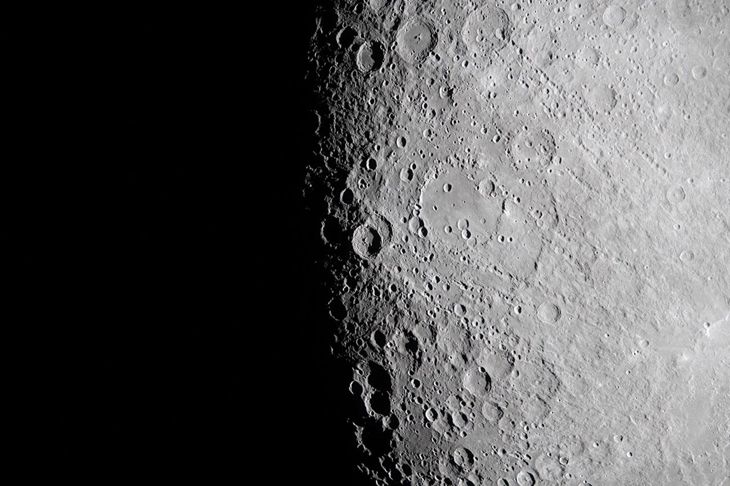
The most revealing views came near the lunar terminator, the moving boundary between day and night. There, sunlight strikes the ground at a shallow angle. Crater rims, ridges, and mountains cast long shadows, making relief easier to see than it is under overhead light. Because the Moon has no thick atmosphere to scatter sunlight, the change from bright ground to darkness is especially sharp.
Those conditions matter beyond the beauty of the photographs. Near the Moon’s south pole, where future crews are expected to work, the Sun stays low on the horizon and shadows can hide terrain and equipment. Observing the terminator gave the crew practice interpreting a landscape under similarly severe lighting. It also let researchers compare what astronauts noticed with topographic maps made by instruments such as the Lunar Reconnaissance Orbiter’s laser altimeter.
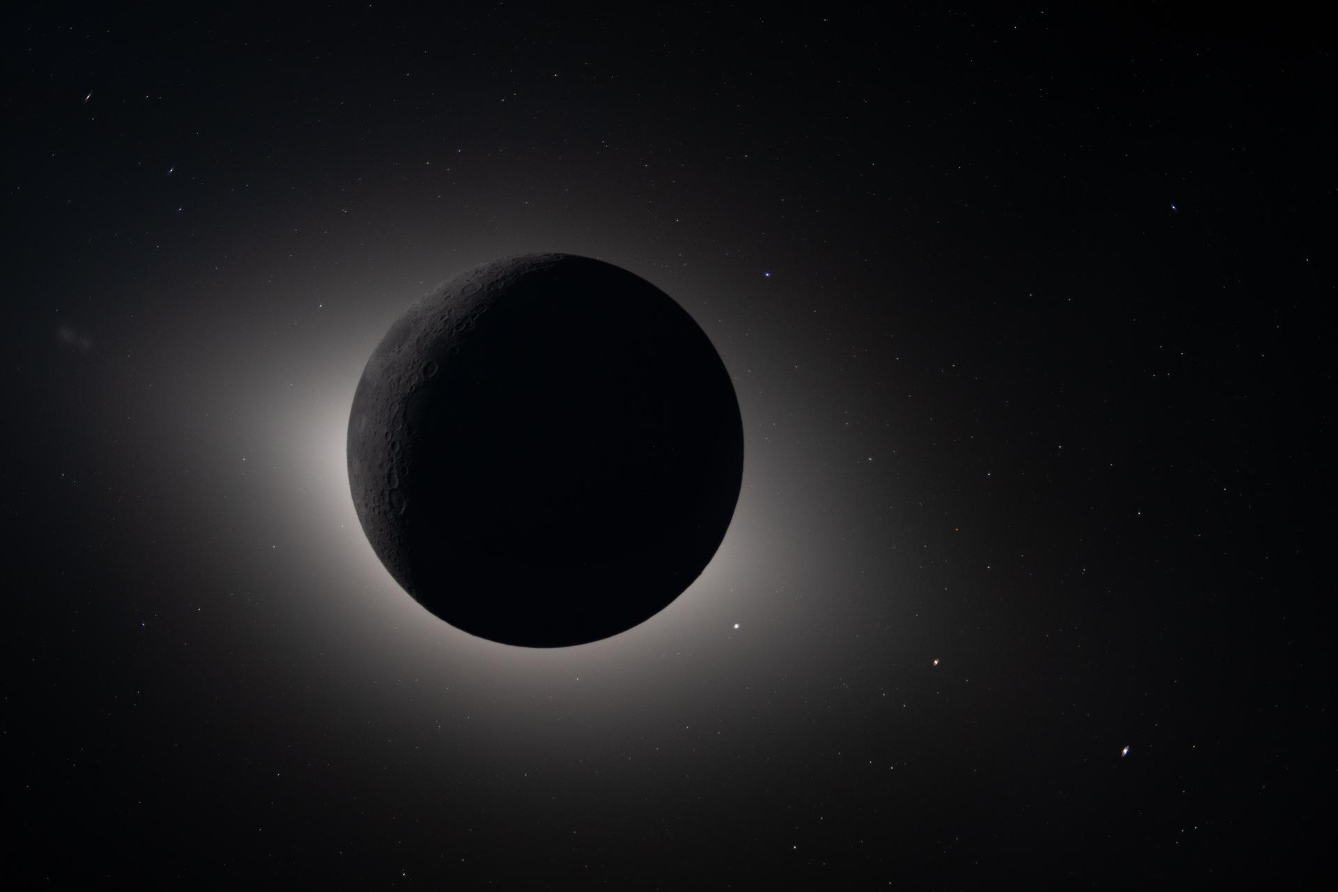
The spacecraft’s path also placed the Moon between Orion and the Sun. From the crew’s viewpoint, the lunar disk covered the Sun for nearly 54 minutes, far longer than totality during an eclipse seen from a narrow path on Earth. With the bright solar surface hidden, the astronauts could examine faint light around the Moon, watch structures in the Sun’s outer atmosphere, and see stars and planets that would normally be washed out. NASA’s report treats some of that faint glow cautiously because it may combine the solar corona with zodiacal light reflected from interplanetary dust. The uncertainty is useful: it marks a question for later analysis rather than turning an impression into a premature answer.
Robotic maps give human observations an address
A spoken observation such as “the surface looks rougher here” has little scientific value if no one can determine where “here” was. Artemis II researchers therefore matched the timing and direction of the crew’s photographs to established lunar maps. Once an image is tied to coordinates, it can be compared with elevation, surface temperature, brightness, slope, and rock-abundance data gathered by orbiters.
NASA’s comparison of the Orientale basin shows the method clearly. Orientale is an enormous impact structure surrounded by concentric mountain rings on the Moon’s western edge as seen from Earth. Crew photographs reveal how the basin looked under a particular angle of sunlight. Lunar Reconnaissance Orbiter data then adds layers showing elevation, roughness, estimated rock abundance, and reflectivity. The human image supplies immediate visual context, while the instruments turn that view into measurements that can be checked and compared.
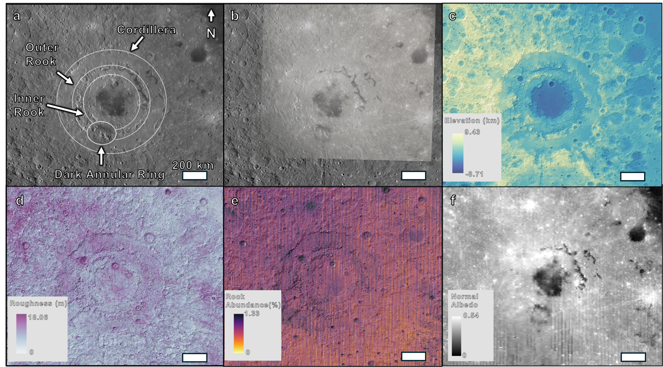
This layered approach also guards against error. A color shift may come from a mineral difference, but it may also come from glare or camera processing. A shadow may reveal a ridge, or it may hide the feature’s true shape. Checking observations against independent datasets makes it possible to separate a promising clue from an optical effect. Human attention helps select questions; calibrated instruments help test them.
A rehearsal for science on the lunar surface
NASA deposited the Artemis II collection in its Planetary Data System, where researchers can revisit the original files rather than rely only on selected publicity images. The release includes photographs, video, audio, annotations, a preliminary science report, an operations report, and a user guide. Keeping the pieces together matters because a photograph becomes more informative when researchers can hear what the photographer was describing and see how the observation was located on a map.
The mission also tested the less visible parts of field science: how much training astronauts need, how observers divide limited window time, how mission control handles questions, and how data should be labeled for people who were not present. On a future landing, those decisions will be harder. Crews may have to choose among rock samples, describe a site before disturbing it, and adjust a plan when time, power, communications, or safety constraints tighten.
Artemis II did not return lunar rocks or make a single discovery that settles a major debate about the Moon. Its contribution is more foundational. It showed that astronauts can produce a coherent scientific record while operating a new spacecraft in deep space, and that their observations become far stronger when they are connected to robotic measurements. The 800-gigabyte archive is therefore more than a collection of striking views. It is a working example of how exploration becomes evidence.