 Akshay Dinesh
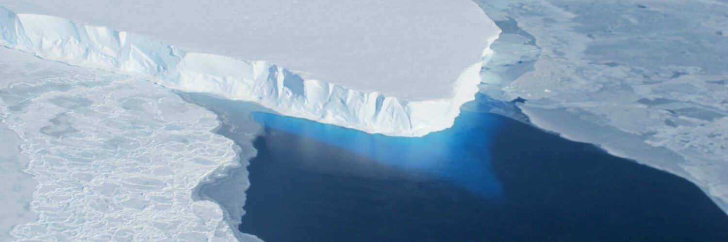
Thwaites Glacier meets the Amundsen Sea at one of the most consequential boundaries on Earth. Ice flowing from West Antarctica rests on bedrock inland, then lifts free of the seafloor and continues outward as a floating shelf. For years, many computer models represented that transition as a neat line. Satellite observations now show a messier reality: tides can push seawater several kilometers beneath ice that had been treated as firmly grounded.
That hidden reach of seawater matters because it brings ocean heat into direct contact with the glacier’s underside. A 2026 study in Nature Communications, led by Mattia Poinelli with researchers from the University of California, Irvine, NASA’s Jet Propulsion Laboratory, Dartmouth College, and other institutions, built this process into an ice-sheet model. The revised model reproduced nearly three decades of observed retreat more successfully and produced higher sea-level estimates for 2100 than comparable models that treat the transition as a sharp boundary. The result is not a countdown to sudden collapse. It is a clearer picture of a process that earlier projections may have simplified too much.
Why Thwaites draws so much attention
Thwaites is enormous, covering an area comparable to Florida or Great Britain. More important than its surface area is its setting. Much of the West Antarctic Ice Sheet rests on bedrock below sea level, and the bed generally deepens farther inland. That geometry can make retreat difficult to stop: once the glacier’s edge moves off a ridge into deeper water, thicker ice is exposed at the boundary, allowing more ice to flow toward the ocean.
The glacier is already losing mass and helping raise global sea level. The International Thwaites Glacier Collaboration reports that Thwaites contains enough ice to raise the global average sea level by about 65 centimeters if it were eventually lost in full. That figure describes the glacier’s total long-term sea-level equivalent, not a prediction for this century. A complete collapse is not expected within the next few decades, and scientists remain uncertain about how fast the glacier will change.
Thwaites also helps restrain neighboring parts of the ice sheet. Its floating ice does not directly raise sea level when it melts, because it already displaces seawater, but an ice shelf acts like a brake on the grounded ice behind it. Thinning, fracturing, or unpinning that floating extension can let inland ice flow faster. This is why researchers care about the mechanics at the place where grounded and floating ice meet, even though that place is hidden beneath hundreds of meters of ice.
A grounding zone is not a fixed line
Picture a board lying partly on a beach and partly over the water. The point where it stops resting on sand may seem fixed, but waves can lift and lower it, letting water reach beneath the section that looked supported. The glacier’s transition is vastly larger and more complicated, yet the comparison captures the central idea. A tide can flex the ice and move the point of contact back and forth.
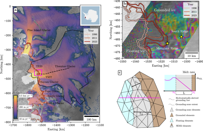
Scientists traditionally call the boundary the grounding line. In many models, ice on one side is grounded and ice on the other is floating, with the change occurring across a narrow mathematical edge. High-resolution radar observations from the ICEYE satellite constellation revealed that Thwaites behaves more like a grounding zone. Pressurized seawater can intrude several kilometers inland beneath the ice during tidal cycles, temporarily lifting sections away from the bed.
The water involved is modified Circumpolar Deep Water, which is warm relative to the freezing point at that depth. Even water only modestly above the local freezing temperature can melt large amounts of ice when it repeatedly reaches the glacier’s base. The intrusion also moves ocean-driven melting inland of the conventional flotation boundary, attacking areas that models may otherwise treat as protected by contact with the bed.
This does not mean seawater forms one permanent underground river. The observations suggest a shifting, tide-sensitive region in which water advances, retreats, and flushes beneath the ice. Its width, the melt rate, the shape of the seafloor, and the friction between ice and bed all influence what happens next. Turning that changing region into a usable model is the difficult part.
How the new model was tested against the past
A model earns confidence by doing more than producing a dramatic future number. It should first recreate changes that have already been measured. Poinelli and colleagues initialized the Ice-sheet and Sea-level System Model to represent Thwaites in the mid-1990s, then ran it forward to 2023. They compared the simulations with three independent observational records: ice-flow speed, ice thickness, and the position of the grounding boundary.
The western, fastest-flowing trunk of Thwaites has retreated about 25 kilometers since 1996, according to the study. Its present boundary is partly stabilized by Mouginot Ridge, a rise in the seafloor roughly 950 meters below sea level. Models need to reproduce not only that retreat but also the glacier’s thinning and acceleration. Matching just one measurement could hide a wrong explanation for the others.
Simulations with actively melting grounding zones two to five kilometers wide were best able to reproduce all three observed changes together. NASA’s Jet Propulsion Laboratory summarized the improvement by reporting that a model including the zone matched the historical satellite record four times more closely than versions without it. In the paper’s statistical analysis, simulations lacking a grounding zone were four times less likely to reproduce the historical trend.
The match was not perfect. The model initially overestimated retreat in the eastern ice shelf sector and required an adjustment within the uncertainty of existing seafloor maps. It also does not yet include every possible effect, such as reduced friction when seawater lubricates the bed. Those limitations are valuable to state plainly. The study strengthens the case for modeling grounding-zone melt, but it does not remove every uncertainty beneath a glacier that is extraordinarily hard to observe.
What the sea-level projections do and do not say
After calibrating the model against the past, the researchers extended it to 2100. They held climate forcing at the average conditions experienced from 1996 to 2023. This controlled baseline isolates the effect of grounding-zone processes rather than attempting to predict every future change in ocean temperature. The authors describe it as a lower-bound forcing scenario, but that phrase should not be confused with a guaranteed minimum sea-level outcome; it is a particular modeling experiment with defined assumptions.
When the simulation omitted a grounding zone, Thwaites contributed an estimated 8.3 millimeters to global mean sea level by 2100, with an uncertainty of about 3 millimeters. A narrow zone raised the estimate to roughly 14.3 millimeters. With a zone centered around three kilometers, the estimate reached 19.4 millimeters, about 130 percent above the comparison-model mean. Some simulations with longer zones produced up to 30 millimeters, or 3 centimeters, with an uncertainty of about 6 millimeters.
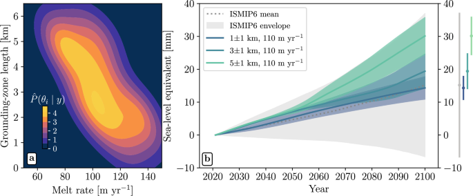
Three centimeters averaged across the world’s oceans may sound small beside the glacier’s 65-centimeter total potential. The two values answer different questions. The larger number imagines the eventual loss of the whole glacier; the new study estimates one glacier’s contribution through 2100 under a controlled set of assumptions. Global sea level also reflects thermal expansion, mountain glaciers, Greenland, other parts of Antarctica, and changes in water stored on land.
Small changes in average sea level can still have large local consequences. A higher baseline allows storm surge and high tides to reach farther inland, increases the frequency of threshold-crossing floods, and can worsen saltwater intrusion. The rise will not be identical everywhere because gravity, ocean circulation, land movement, and the redistribution of ice mass shape regional sea levels. The practical question for coastal planning is not whether Thwaites alone produces a catastrophe, but how its contribution adds to every other source.
Better forecasts begin at a hidden boundary
The study changes neither the existence of uncertainty nor the basic reason Thwaites is retreating. Warm ocean water is melting the glacier from below, and the seafloor beneath it creates routes toward deeper inland ice. What changes is the model’s description of the place where those forces meet. A boundary that moves with the tides and admits seawater inland behaves differently from a permanent line.
Future observations can test the result more sharply. Satellites can keep tracking speed and grounding-zone movement, while radar, autonomous underwater vehicles, and field instruments can improve maps of the bed and measurements of ocean heat. Researchers can also add grounding-zone physics to other ice-sheet models to see whether independent systems produce similar results. Agreement across observations, methods, and models matters more than any single projection.
Calling Thwaites the “Doomsday Glacier” can make the science sound like a switch waiting to flip. The evidence points instead to an immense system changing over decades and centuries, with rates that depend on hidden terrain, ocean circulation, ice mechanics, and future warming. That slower story is not comforting, but it is more useful. Understanding a few kilometers of moving water beneath the ice can sharpen decisions made thousands of kilometers away, along coastlines where every added centimeter changes the odds.