 Akshay Dinesh
A volcano does not have to send lava into a town to become dangerous. In many places, the larger threat is a rushing mixture of water, ash, rock, soil, and broken debris that moves downhill through river valleys. That flow is called a lahar, and it can behave less like an ordinary flood than a moving mass of wet concrete.
Lahars matter because they connect geology with geography. A steep volcanic cone, a glacier, a snowfield, a crater lake, a rainy season, or a river channel can all help shape where the danger goes. People living many miles from a crater may still be in a lahar path if their town sits on a valley floor that drains the volcano.
What makes a lahar different from a normal flood
A normal flood is mostly water, even when it carries mud, branches, or sediment. A lahar is a debris flow tied to volcanic material. It may begin during an eruption, when hot rock and ash melt snow or ice, or when heavy rain mixes with loose volcanic ash. It can also begin without a fresh eruption if part of a weakened volcano collapses into a drainage and mixes with water.
That mixture changes how the flow moves. Water gives it mobility, while ash, sand, boulders, trees, and building fragments give it weight and grinding power. The National Park Service describes lahars as flows that can travel down valleys at speeds of 45 to 50 miles per hour or more on steep slopes. Some are watery and spread like muddy floodwater; others are thick enough to carry large boulders and push against bridges, houses, and roads with tremendous force.
The word itself comes from Indonesia, where volcanic landscapes and heavy tropical rainfall make mudflows a familiar hazard. The idea is global. Lahars have affected communities near volcanoes in the Andes, the Cascades, Japan, the Philippines, Indonesia, and New Zealand. They are not rare curiosities. They are one of the main ways volcanoes can harm places downstream.
Why valleys can carry danger far from the volcano
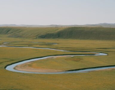
Volcanoes often sit above networks of streams and rivers. Those channels are efficient downhill routes, which is useful for water and dangerous for debris. Once a lahar enters a valley, the valley walls can guide it forward, keeping the flow concentrated instead of letting it spread out harmlessly across open ground.
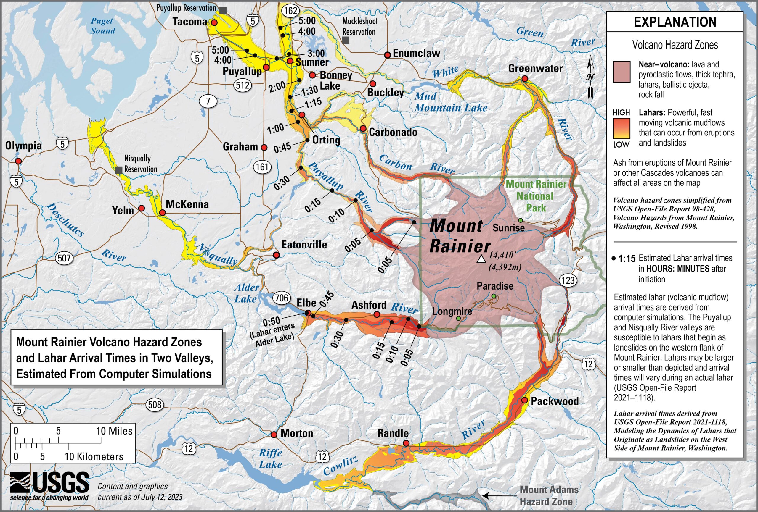
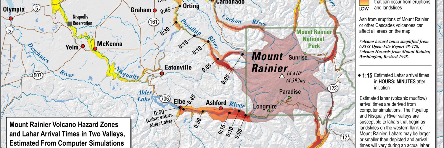
This is why lahar maps often look like branching fingers reaching away from a volcano. The highest risk does not form a neat circle around the crater. It follows drainage basins, river bends, lowlands, and old deposits left by earlier flows. A neighborhood closer to the volcano but on high ground may be safer than a town farther away on a valley floor.
Mount Rainier in Washington shows why this matters. The U.S. Geological Survey has found evidence for at least nine large lahars from Mount Rainier in the last 5,600 years that reached into the Puget Lowlands. Modern communities, highways, bridges, ports, and pipelines now occupy some of the same lowland corridors. The volcano is not only a mountain in a national park; it is also the headwaters for valleys where many people live and travel.
One especially important detail is that lahars do not always require a dramatic eruption. USGS scientists note that Mount Rainier’s Electron Mudflow, around 1500 A.D., appears to have started as a large landslide rather than an eruptive event. Hydrothermally altered rock inside a volcano can become weaker over time, almost like solid rock slowly being changed into clay-rich material. If enough of that material fails, gravity and water can do the rest.
How ash, ice, rain, and rock become one moving mass
Several ingredients can start a lahar, but the recipe usually includes loose volcanic material, water, and a slope steep enough to build momentum. During an eruption, pyroclastic flows or hot ash can melt snow and glacier ice very quickly. Rain can fall onto fresh ash deposits and turn them into unstable slurry. A crater lake can breach. A landslide can collapse into a river channel. Each path begins differently, but the result is a flow that gathers more material as it moves.
The flow also changes along the way. A lahar may start thick and boulder-rich near a volcano, then become more watery downstream, or it may pick up sediment, trees, vehicles, and pieces of structures as it travels. Its front can arrive as a churning wall of debris, followed by pulses of mud and water. This pulsing behavior makes the hazard hard to judge by eye. A lull does not always mean the flow is finished.
The 1985 disaster at Nevado del Ruiz in Colombia remains one of the clearest warnings about how deadly lahars can be. After an eruption melted ice and snow on the volcano, mudflows raced down multiple valleys. The Smithsonian Global Volcanism Program reports that the flow into Armero killed an estimated 21,000 of the town’s 25,000 residents. The tragedy is remembered not only because of the eruption, but because hazard maps and warnings existed yet did not lead to a timely evacuation.
That history is one reason scientists stress communication as much as geology. A hazard map is not useful if people do not understand it, trust it, or know what to do when a warning arrives. The science can show where a lahar is likely to go, but communities still need drills, routes, signs, sirens, alerts, and plain language.
How scientists map and monitor lahar risk
Lahar hazard maps begin with the shape of the land. Scientists study old deposits, river valleys, volcanic slopes, landslide scars, glaciers, and areas of weakened rock. They also use computer models to estimate how a flow of a certain size could move through a drainage. The maps are not promises about exactly where a future flow will stop. They are planning tools that show which areas deserve special attention.
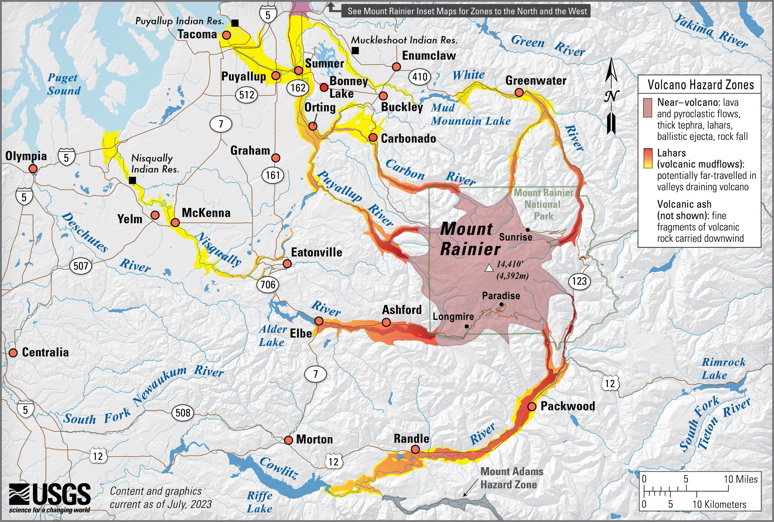
At Mount Rainier, USGS modeling has estimated that a large lahar beginning on the volcano’s west side could reach some residential areas inside the park in about five minutes and some residential areas outside the park in 15 to 60 minutes. Those numbers explain why waiting to see the flow is not a practical strategy in many valleys. By the time a lahar is visible nearby, the safest time to move may already be passing.
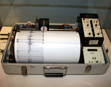
Monitoring systems try to gain time. The Mount Rainier lahar detection network uses instruments such as tripwires, seismometers, infrasound sensors, cameras, and other field equipment to detect signs that a lahar is moving down a drainage. Older acoustic flow monitors measured ground vibrations from passing flows. Newer systems send real-time signals and aim to detect flows earlier, estimate location, and support faster warnings.
Recent regional drills show how this science becomes community practice. East Pierce communities in Washington scheduled a 2026 full-scale lahar evacuation exercise involving more than 50 facilities, with students, schools, local governments, and emergency managers practicing how to move away from mapped hazard areas. Drills like that are not about panic. They are about making the route to high ground familiar before anyone has to think under pressure.
Warnings still have to reach people in the right places. That can involve emergency alerts, sirens, radio, television, local officials, schools, and public safety agencies. In some areas, natural warning signs also matter: strong ground rumbling, a roar like a train or jet, or a sudden muddy surge in a river channel. For people in mapped lahar zones, the basic geographic lesson is simple: low valley floors are the places to leave, and high ground is the direction to know before an emergency.
Why lahar awareness is really about reading the landscape
Lahars are powerful because they turn familiar landforms into pathways. A river valley that normally carries snowmelt, rainwater, fish, roads, trails, and towns can also carry volcanic debris. A beautiful mountain view can hide a drainage network that matters more than distance from the summit. A flat, convenient place to build may be flat precisely because past flows spread sediment there.
That does not mean every volcanic valley is doomed or that people should treat volcanoes only with fear. It means the landscape has a memory. Old deposits, valley shapes, river routes, and hazard maps are ways of reading that memory before the next event. The more clearly people understand the pattern, the less a lahar has to arrive as a surprise.
Good lahar education also avoids a common mistake: imagining volcano hazards as only spectacular eruptions. Lava is dramatic, but it usually moves slowly enough for people to get away. Lahars can be quieter at first, faster in valleys, and dangerous long after ash has fallen or long after an eruption seems distant. They show that volcanic risk is not just about what comes out of a crater. It is about where water and loose rock can go once gravity takes over.
Seen that way, a lahar map is more than a warning document. It is a geography lesson written across slopes, rivers, towns, and time. It shows how mountains shape lowlands, how past events leave clues, and how science can turn those clues into decisions that give people a better chance to move before the valley fills with mud.