
Look at a county road map in much of the Midwest or West and a pattern quickly appears: straight roads, square fields, section lines, and towns that seem to sit inside a giant checkerboard. That pattern was not an accident of geography. It grew from a decision made by the Confederation Congress on May 20, 1785, when the young United States tried to solve one of its biggest problems with measurement, maps, and land sales.
The Land Ordinance of 1785 did not create a state government, write a constitution, or settle the political status of western territories. Its job was more practical and, in some ways, more quietly powerful. It told surveyors how to divide federal land in the Northwest Territory so it could be described, sold, taxed, and eventually settled with fewer boundary fights. The result was a rectangular survey system that helped shape the physical layout of large parts of the country.
A Young Government With Land but Little Money
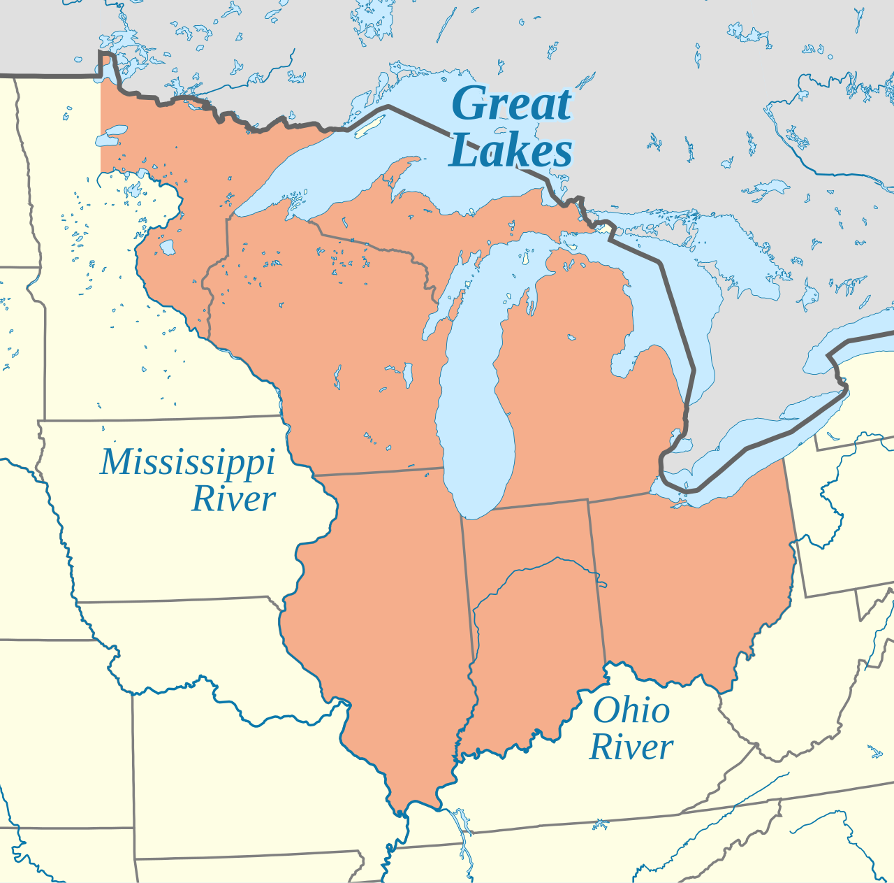
After the American Revolution, the national government under the Articles of Confederation was short on cash and weak in several important ways. Congress could request money from the states, but it could not collect taxes directly in the way the later Constitution allowed. At the same time, the United States claimed large western lands north of the Ohio River and east of the Mississippi River. Those lands were politically valuable, but they could not easily support the government unless they were surveyed and sold in an orderly way.
The U.S. House history office describes the ordinance as a plan for transferring ownership of land in the Northwest Territory from the federal government to states and individual landowners. That phrase sounds plain, but it points to a major challenge. Before land could be sold fairly, people had to know where one tract ended and another began. Vague claims, overlapping grants, rivers that shifted course, and hand-drawn local descriptions could all lead to conflict. A survey grid promised something cleaner: numbered parcels that could be recorded and compared on a map.
Land sales also offered a way to raise revenue. Instead of relying only on state payments, the Confederation government could sell surveyed public land and use the income to help pay debts. The system was not equally accessible to everyone, since the size and price of parcels often favored speculators and buyers with capital. Still, the ordinance gave the government a concrete method for turning western land claims into surveyed property.
Townships, Sections, and the Logic of the Grid
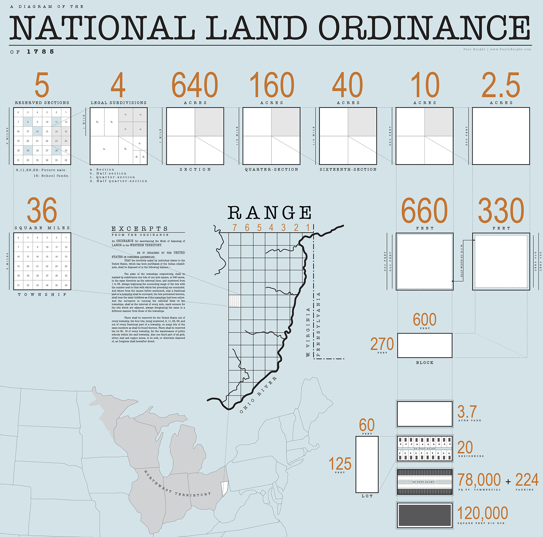
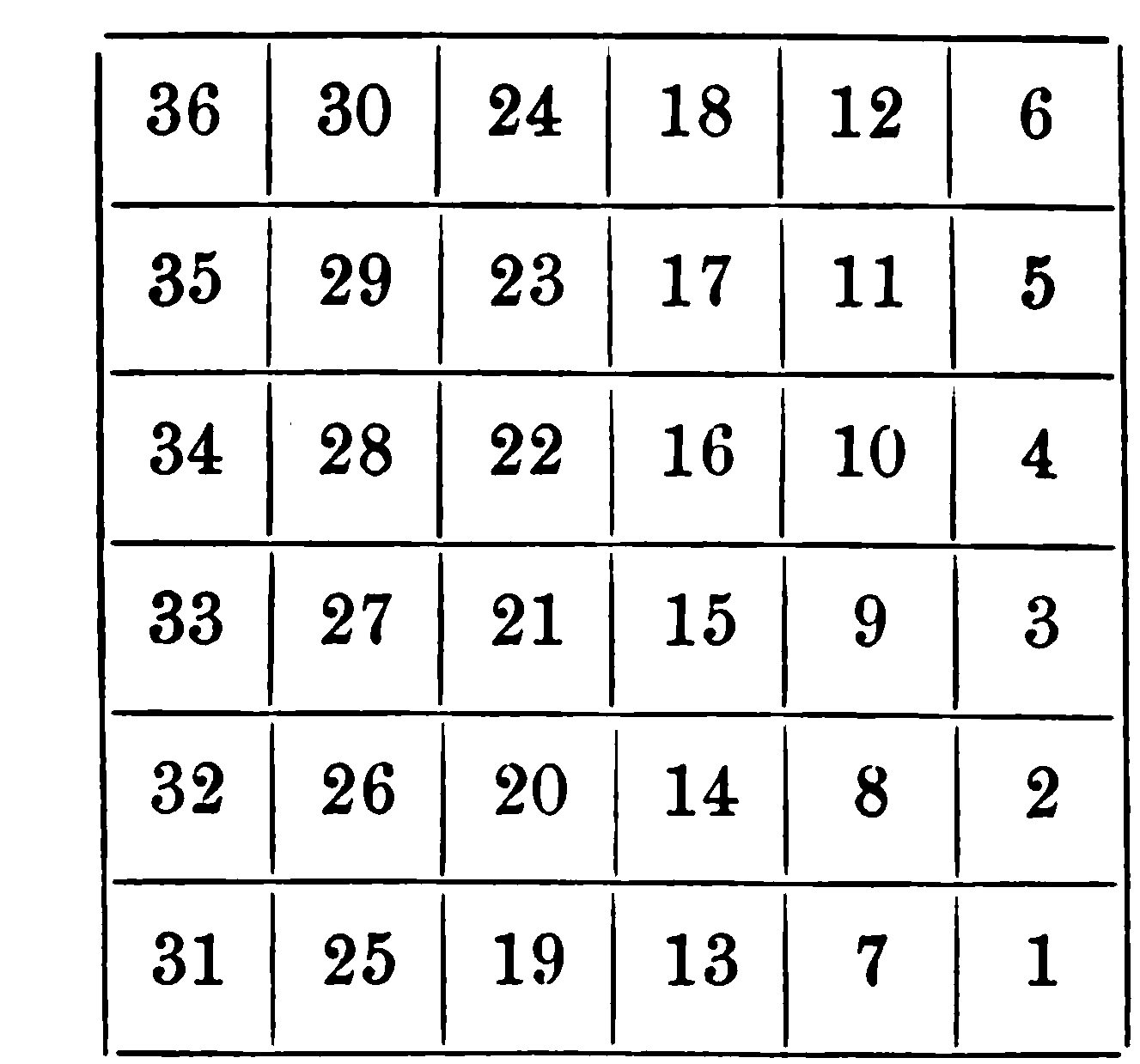
The heart of the ordinance was its geometry. Surveyors were to divide land into townships six miles square. Each township contained 36 square miles, and each square mile became a section of 640 acres. A section could then be subdivided into smaller parcels. In a world before digital maps, GPS, or easy long-distance recordkeeping, this system made land descriptions portable. A buyer, official, or surveyor could refer to a range, township, and section rather than relying only on local landmarks.
The grid did not remove all confusion. Real landscapes contain rivers, hills, wetlands, older claims, Indigenous homelands, and human communities that do not fit neatly inside squares. Survey lines could be delayed, corrected, or adjusted. But the basic idea was influential because it created a repeatable language for land. Once the government accepted that language, it could spread across new public lands with relatively consistent rules.
This is why the Land Ordinance belongs in both history and geography. It was a political decision, but it left a visible geographic pattern. Roads often followed section lines because those lines marked property boundaries. Farms were bought, sold, inherited, and divided according to surveyed parcels. County maps, land deeds, and rural addresses grew around the same rectangular logic. The grid became a kind of quiet infrastructure: easy to overlook because it was built into the map itself.
Section 16 and the Idea of School Lands
One of the ordinance’s most lasting ideas was the reservation of section 16 in each township for public schools. The language was simple: lot number 16 was to be reserved for the maintenance of public schools within the township. The plan did not create modern public education by itself, and different states handled school lands in different ways. Some lands were sold to raise funds; others were leased or managed over time. Even so, the principle mattered.
The new government was saying that education should be built into settlement planning, not treated only as an afterthought. The choice of a numbered section also shows how practical the ordinance was. Rather than promising a vague future commitment, it tied school support to a specific piece of land in every township. In a country where public revenue was uncertain and local institutions were still forming, land became a tool for funding civic life.
That idea was not perfect in practice. The benefits of school lands depended on local management, land value, state policy, and who was included in public education. The ordinance also sat inside a broader expansion process that displaced Native nations and ignored their sovereignty. A clear grid on a federal map did not mean the land was empty, unused, or uncontested. Understanding the ordinance requires holding both facts together: it created an orderly land system for the United States, and it helped advance expansion into places where other peoples already lived.
How It Connected to the Northwest Ordinance
The Land Ordinance of 1785 is often paired with the Northwest Ordinance of 1787, but they answered different questions. The 1785 law asked: how should public land be measured and sold? The 1787 ordinance asked: how should the Northwest Territory be governed, and how could new states eventually enter the Union? One handled the survey and sale of land. The other set up territorial government, civil rights protections, and a path toward statehood.
Together, the two ordinances show one of the stronger achievements of the Confederation period. The Articles of Confederation government struggled with taxation, trade, and enforcement, but it did create a framework for western land policy. That framework helped the United States imagine expansion as a repeatable process: survey the land, sell parcels, organize territories, and eventually admit states. The process looked orderly on paper, even when the lived reality was far more contested.
The connection also helps explain why the ordinance still appears in lessons about the early republic. It was not just a land-sales rule. It linked revenue, settlement, schools, state formation, and national power. A government that could not yet tax effectively still found a way to use land policy to shape its future.
Why the Grid Still Matters
The Bureau of Land Management notes that modern cadastral surveys, which define and reestablish boundaries of public lands, trace their origin to the Land Ordinance of 1785. That does not mean every American property line comes from the ordinance. Older colonies, Spanish and French land grants, metes-and-bounds descriptions, railroads, Indigenous treaties, natural boundaries, and later legal changes all complicate the map. But across much of the public-land states, the rectangular survey system became the basic frame.
Its effects show up in ordinary places. A rural road may run exactly one mile before meeting another. A farm may occupy a quarter section. A township line may shape a school district, a county record, or a local boundary. Even people who never study the ordinance can live inside its geometry. That is why the Land Ordinance of 1785 is more than a date to memorize. It is a reminder that laws can become landscapes.
The ordinance also raises bigger questions about how societies turn space into property. A grid can make land easier to sell, govern, and tax. It can reduce some disputes while creating or hiding others. It can support schools and local institutions while also speeding expansion into contested territory. The same straight lines that made maps legible to federal officials could cut across older relationships to land that did not fit the surveyor’s square.
Seen that way, the Land Ordinance of 1785 was both practical and transformative. It gave the young United States a method for measuring its western claims, selling public land, reserving school sections, and organizing growth. Its legacy is visible whenever a map turns into a checkerboard of roads and fields. The grid was a tool of government, but it became part of daily life.


Add comment