
Some ancient cities are not truly lost. They are covered, disguised, or folded into the landscape so well that a person can walk nearby without realizing what is under the trees. In tropical forests, old roads, terraces, reservoirs, platforms, and house foundations may sit beneath roots and leaves for centuries. From the ground, the evidence can look like nothing more than a low rise, a line of stones, or a patch of uneven soil. From above, with the right tool, a whole city plan can begin to appear.
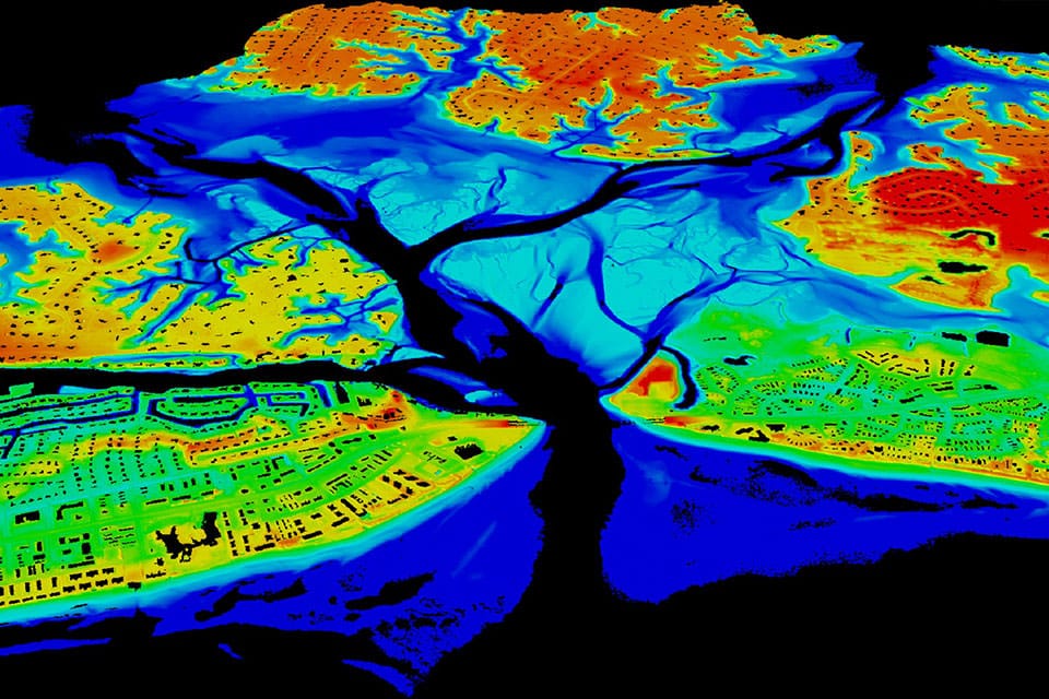
That tool is LiDAR, short for Light Detection and Ranging. It does not replace careful field archaeology, but it changes where archaeologists can look and what questions they can ask. By sending laser pulses from an aircraft and measuring how long the light takes to bounce back, LiDAR can create a detailed model of the ground. When researchers filter out the vegetation in the data, buried patterns become easier to see: plazas, canals, walls, causeways, platforms, and the faint outlines of neighborhoods that once held daily life.
How a Laser Turns Forest Into a Map
LiDAR works by timing light. A sensor sends out rapid pulses of laser light, and each pulse travels until it hits something: a leaf, a branch, a wall, the ground, or another surface. The sensor records the returning light and pairs it with GPS and motion data from the aircraft. After millions or billions of measurements, the result is a dense collection of elevation points often called a point cloud.
NOAA describes LiDAR as a remote-sensing method that uses pulsed laser light to measure distances to Earth’s surface and create precise three-dimensional information about land and features on it. The same basic idea helps map shorelines, flood risk, forests, buildings, and riverbeds. In archaeology, the important trick is that some laser pulses pass through small gaps in the canopy and reach the ground. Those ground returns allow researchers to model the terrain beneath vegetation.
The raw data does not magically label a pyramid or road. Archaeologists and mapping specialists process the point cloud, remove much of the tree cover, and turn the measurements into shaded maps, slope models, and elevation images. A low platform may stand out as a geometric shape. A road may appear as a raised line. A reservoir may show as a basin with constructed edges. The patterns are still interpretations, but they give researchers a much stronger starting point than walking blindly through dense forest.
Why Hidden Cities Stay Hidden for So Long
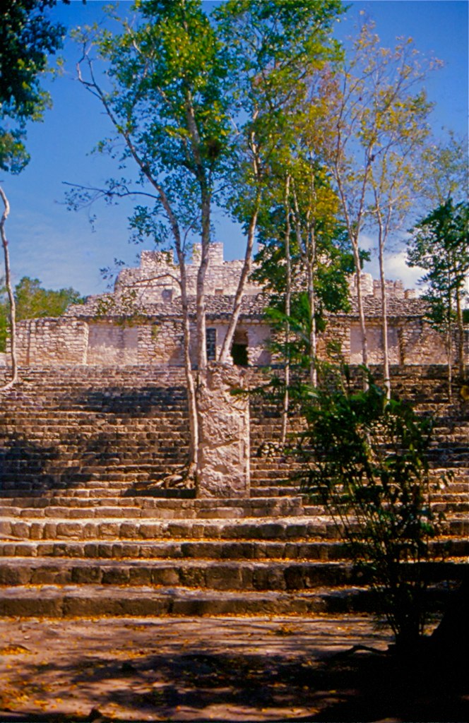
Many ancient urban landscapes were built with local materials that weather into the environment. Stone buildings collapse, wooden roofs vanish, plaster erodes, and soil slowly gathers over floors and walls. In humid regions, forest growth can cover a site quickly. Tree roots split masonry, vines hang over stairways, and fallen leaves soften sharp edges into natural-looking mounds.
Traditional survey work is slow because it depends on human movement through difficult terrain. Archaeologists may need to clear narrow paths, measure features by hand, and decide whether a small rise is natural or cultural. That work remains essential because artifacts, construction details, soil layers, and dates usually require close inspection. But without a broad map, researchers may miss how separate features connect. A causeway, field system, or neighborhood pattern can be too large to understand from one trench or one hilltop.
LiDAR helps by changing the scale of observation. Instead of seeing one ruin at a time, researchers can see the relationships among many features across a wide area. That matters because cities are not only temples and palaces. They are also roads, water systems, farms, homes, workshops, defensive walls, and ordinary spaces where people cooked, traded, repaired tools, and raised families.
The Maya Lowlands Show Why LiDAR Matters
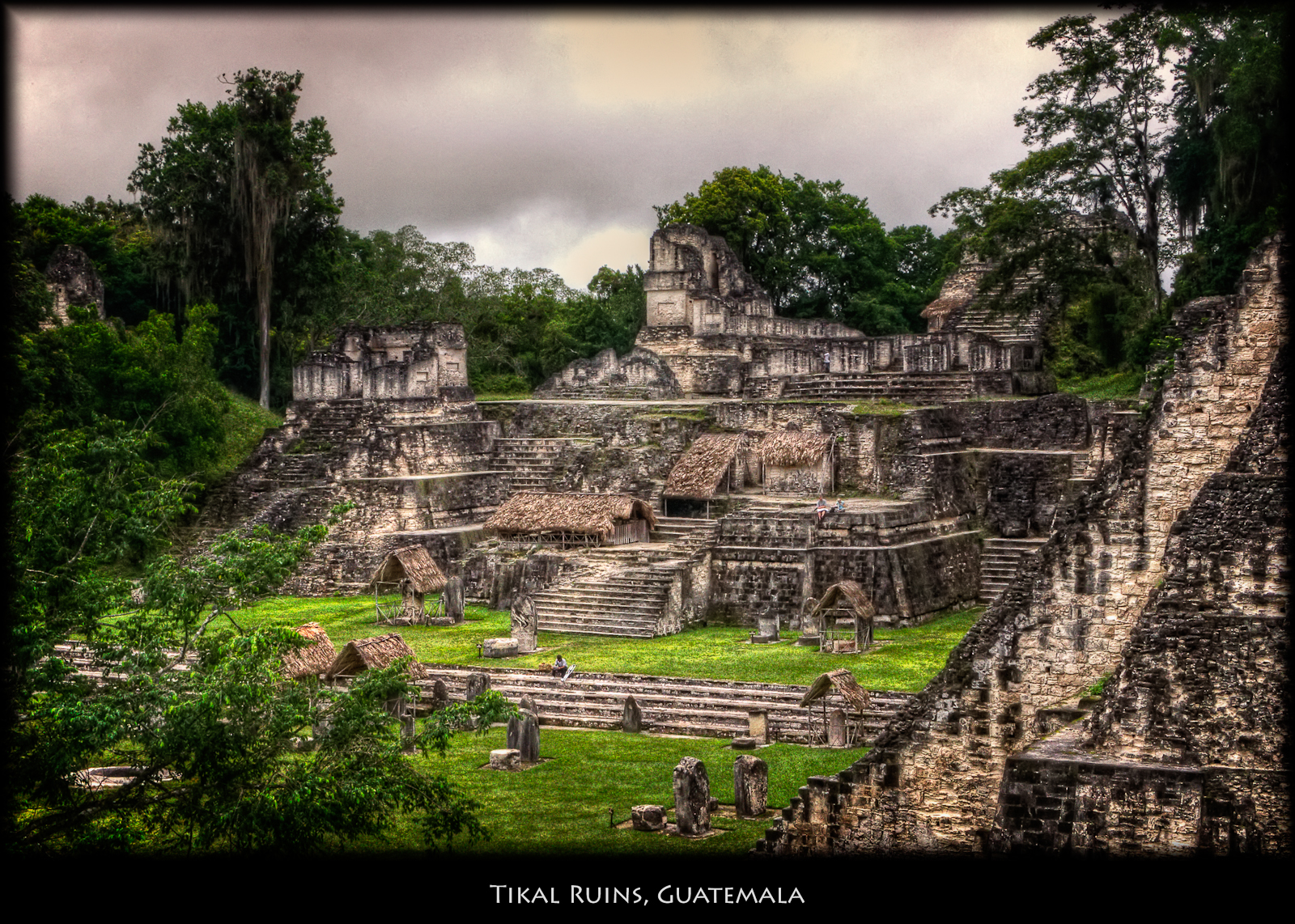
The ancient Maya world has become one of the clearest examples of LiDAR’s power. For many years, dense forest made it hard to understand how large and connected some Maya landscapes were. Famous ceremonial centers were known, but the spaces between them were harder to map. LiDAR surveys have helped reveal that many areas were filled with settlement, infrastructure, and modified land rather than empty jungle between isolated cities.
A 2024 study in Antiquity examined an environmental LiDAR dataset from Campeche, Mexico. The data had not originally been collected for archaeology; it came from work connected to environmental mapping. When researchers analyzed it for ancient remains, they found previously unrecorded urbanism and dense settlement across the central Maya Lowlands. One of the most striking results was the identification of Valeriana, a large Maya city hidden in the landscape.
Reports on the discovery described Valeriana as a city with temple pyramids, enclosed plazas, a ballcourt, a reservoir, causeways, and two major centers connected by settlement. That combination matters. A pyramid may be dramatic, but a reservoir and causeways reveal planning, labor, water management, and movement. The city was not simply a pile of impressive monuments. It was part of a living urban system shaped by politics, farming, ceremony, trade, and the practical problem of sustaining people in a seasonal environment.
What LiDAR Can Show and What It Cannot
LiDAR is powerful because it can reveal shape, height, and pattern. It can suggest where walls once stood, where roads ran, where water collected, and where houses may have clustered. It can also show how people changed land at a regional scale, including terraces, canals, reservoirs, and field boundaries. These features help historians and archaeologists ask better questions about population, food production, transportation, and political organization.
But LiDAR does not answer every question by itself. It cannot usually tell exactly when a structure was built, who lived there, what language they spoke, what rituals they practiced, or why a city declined. A geometric mound in the data may be promising, but it still needs field checking. Archaeologists must compare the map with pottery, soil layers, inscriptions, building styles, carbon dates, and other evidence.
That limitation is not a weakness. It is how good evidence works. LiDAR gives researchers a sharper map of possibilities, and fieldwork tests those possibilities. A responsible interpretation keeps both parts together: the wide aerial view and the close human work of excavation, documentation, and comparison.
Why the Discovery Changes the Questions
One of the most valuable effects of LiDAR is that it shifts attention from single monuments to whole landscapes. Older popular images of ancient cities often focus on a temple rising above the trees. LiDAR encourages a different view: the temple sits inside a network. Around it may be reservoirs, agricultural terraces, smaller platforms, pathways, walls, markets, and houses. That wider view makes ancient people less abstract and more real.
It also challenges simple assumptions about what counts as a city. Modern readers may imagine cities as dense blocks of streets and buildings, but ancient urban life could take different forms. Some cities were compact and crowded. Others spread across a large area with fields, gardens, reservoirs, and ceremonial centers woven together. The Maya Lowlands show that urbanism does not always look like a modern downtown. It can be green, spread out, engineered, and still deeply organized.
The Valeriana discovery is especially useful because it came from data gathered for another purpose. That means future discoveries may already be sitting in environmental, forestry, or mapping archives. A researcher with a new question can return to old data and see a landscape differently. In that sense, archaeology is not only about digging deeper into the ground. Sometimes it is about looking more carefully at information that already exists.
A Clearer View of the Human Past
LiDAR does not make archaeology effortless, and it does not turn history into a finished map. What it does is widen the field of vision. It helps researchers find patterns too large, too faint, or too hidden to recognize from the ground alone. It shows that forests can cover cities without erasing them, and that ordinary features such as roads, reservoirs, and house platforms can be as historically important as famous monuments.
For learners, the lesson is bigger than one technology. The past is not fixed only by what people have already found. It changes as tools improve, as questions sharpen, and as researchers connect evidence in new ways. LiDAR reveals hidden ancient cities because laser pulses can pass through leaves, but the deeper discovery is human: old landscapes still hold stories of planning, labor, adaptation, and community. Seeing those stories clearly takes both technology and careful historical judgment.


Add comment