Route 66 is turning 100 in 2026, which makes it easy to treat the road as a collection of neon signs, diners, souvenir shields, and road-trip nostalgia. Those images are part of its story, but they are not the whole story. Route 66 matters because it shows how a transportation route can change the geography of a country: where people stop, where businesses grow, which towns become visible, and which places are left behind when traffic moves somewhere else.
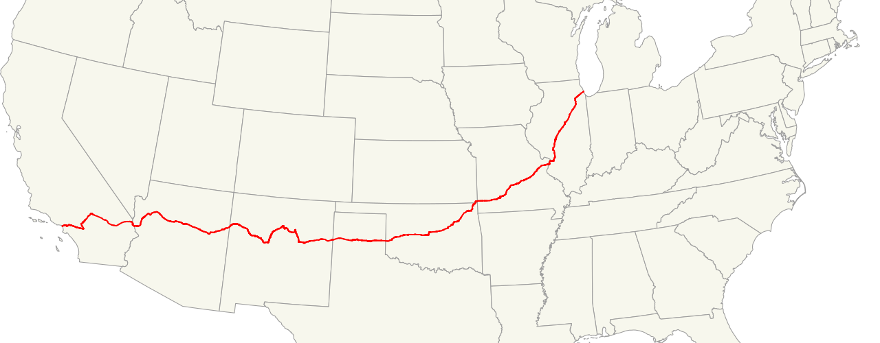
The old highway ran roughly 2,400 miles from Chicago toward Southern California, crossing Illinois, Missouri, Kansas, Oklahoma, Texas, New Mexico, Arizona, and California. The National Park Service describes it as more than a roadbed, calling attention to the way its multiple alignments connect the past and the present. That is the useful way to study Route 66. It was a line on a map, but it was also a corridor of farms, mining towns, Plains communities, desert settlements, service stations, motels, military movement, migration, and later preservation. A road can look simple from above; on the ground, it rearranges daily life.
A Road That Linked Regions, Not Just Cities
Route 66 began in 1926, when the Bureau of Public Roads launched the first federal highway system. Like many early numbered highways, it was not created by carving one brand-new path across the continent. It joined existing local, state, and national roads into a route that drivers could recognize and follow. That distinction matters. Geography is often about connections, and Route 66 made older local routes behave like one long national corridor.
The route was diagonal across much of the middle of the country. Instead of simply running straight east-west along one latitude, it pulled together Chicago, St. Louis, the Ozarks, Oklahoma towns, the Texas Panhandle, New Mexico and Arizona highlands, the Mojave Desert, and the Los Angeles region. That diagonal shape helped farmers, truckers, migrants, tourists, and military traffic move between regions that did not all share the same economy or landscape. The route crossed prairie, woodland, ranch land, mesa country, desert, and coastal urban space. Each landscape changed what travelers needed and what towns could sell.

By the late 1930s, Route 66 had become fully paved, according to the National Park Service account of its early years. That was not just a technical improvement. Pavement changed reliability. A route that could be driven in more weather conditions was more useful for trucking, family travel, and long-distance planning. Once people could count on the road, towns along it could count on more through-traffic, and that traffic became part of the local economy.
Why Towns Grew Around the Flow of Travelers
A highway does not only connect places that already matter. It can make new places matter by putting them in the path of movement. Route 66 gave many small communities a stream of potential customers who needed fuel, repairs, meals, lodging, maps, restrooms, and directions. A town that might have been quiet on a railroad timetable or a county map could become important to a driver who needed the next safe stop before nightfall.
This is why the geography of Route 66 is also the geography of roadside business. Motels, gas stations, cafes, garages, trading posts, and signs developed along the right-of-way because travelers created predictable demand. Some businesses were practical. Others learned to catch the eye with unusual architecture, bright paint, or large signs visible from the road. That was not random decoration. It was a response to a specific spatial problem: when customers are moving past you at speed, location and visibility become survival tools.
The road also helped towns imagine themselves as part of something larger. A community along Route 66 could advertise not only its own services but its place in a national journey. That changed local identity. Towns were no longer only near a county line, a farm region, or a railroad stop; they were on the Mother Road. For travelers, that made the next town feel like one chapter in a longer route. For local businesses, it made the highway itself part of the brand.
Migration Made the Road More Than a Travel Route
Route 66 became famous during the Great Depression partly because it carried migrants west, especially people leaving drought and economic hardship in the Plains. John Steinbeck’s 1939 novel The Grapes of Wrath helped fix the phrase Mother Road in public memory, but the real geography was more complicated than a single stream of families driving to California. The National Park Service notes that the road also supported work-relief projects, highway improvement, local commerce, and communities that stayed in place while hardship moved around them.
That complexity is important. A migration route is not only about people who leave. It is also about the towns that sell supplies, the repair shops that keep vehicles moving, the relief work that improves roads, and the destination regions that absorb new workers. Route 66 connected rural struggle to urban opportunity, but it also exposed unequal access to mobility. Not every family could leave. Not every traveler was treated equally on the road. Not every town benefited in the same way.
Studying Route 66 through geography helps avoid a simple romantic version of the story. The road was a path of hope for many people, but it was also shaped by poverty, segregation, land use, federal spending, and local business competition. A highway can offer movement while still reflecting the social limits of its time. That is one reason Route 66 remains useful to study: it turns a familiar symbol into a map of choices, pressures, and uneven opportunity.
The Interstate Era Changed the Map Again
Route 66 did not disappear because people stopped traveling. It lost its main transportation role because a different road system changed the rules. After the Federal-Aid Highway Act of 1956, high-speed interstate highways gradually replaced older two-lane corridors for long-distance travel. The National Park Service identifies I-55, I-44, I-40, I-15, and I-10 as major interstates that replaced U.S. 66 over several decades. In 1985, U.S. 66 was officially decommissioned as a federal highway.
That shift shows one of geography’s sharpest lessons: a change in route can change a town’s future. When traffic is redirected to a faster road, the old main street may lose customers almost immediately. A bypass can be efficient for drivers and damaging for businesses built around slower travel. Some communities adapted by becoming historic destinations. Others declined. A map that looks cleaner from a transportation-planning point of view can be painful from a local economic point of view.
The interstate system also changed how travelers experienced distance. Route 66 encouraged stopping because drivers passed directly through towns. Interstates are designed to reduce interruptions. They move traffic around places as much as through them. That makes travel faster, but it can make the surrounding geography feel less visible. Route 66’s survival as a historic route is partly a response to that loss. People still seek it out because it makes the journey feel connected to specific places again.
Why the Centennial Is a Geography Moment
The 2026 centennial is not only a birthday for a famous highway. It is a chance to ask what should be preserved when a route is no longer needed in the same practical way. The National Park Service Route 66 Corridor Preservation Program supports preservation planning, research, education, and cost-share grants for significant historic resources along the route. That work treats Route 66 as a cultural landscape, not just a strip of pavement.
A cultural landscape includes buildings, signs, road segments, bridges, towns, memories, and the relationships among them. Preserving one motel sign or one gas station can matter, but the larger story depends on understanding why those places appeared where they did. Route 66 teaches that geography is layered. A modern traveler may see a restored sign; underneath it is a history of federal road policy, local entrepreneurship, migration, advertising, automobile ownership, tourism, and bypassed communities.
That layered story is what gives the centennial real educational value. Route 66 is not important only because it is old or photogenic. It is important because it reveals how movement shapes settlement and how settlement shapes memory. Roads decide which places become convenient, which businesses become visible, and which communities have to reinvent themselves when the traffic moves.
At 100, Route 66 is no longer the main way to cross the country. That may be exactly why it is worth studying. Its old alignments show how geography can remain readable after a transportation system changes. The road’s signs, maps, towns, and preserved landmarks remind us that infrastructure is never just concrete and asphalt. It is a set of decisions about connection, speed, opportunity, and what a country chooses to remember.


Add comment